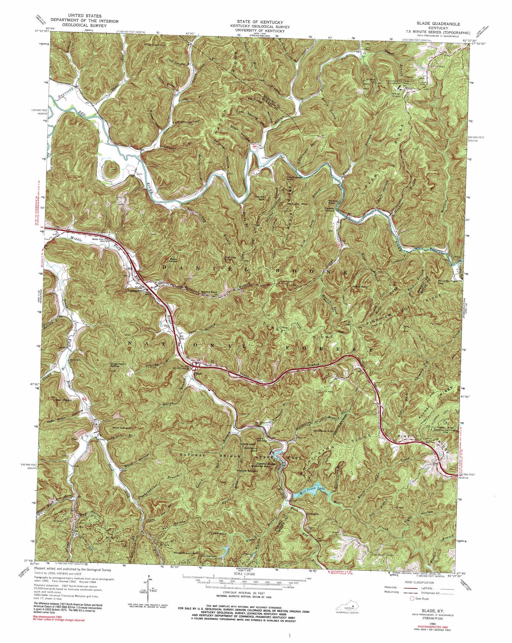
Slade Topo Map Kentucky
To zoom in, hover over the map of Slade
USGS Topo Quad 37083g6 - 1:24,000 scale
| Topo Map Name: | Slade |
| USGS Topo Quad ID: | 37083g6 |
| Print Size: | ca. 21 1/4" wide x 27" high |
| Southeast Coordinates: | 37.75° N latitude / 83.625° W longitude |
| Map Center Coordinates: | 37.8125° N latitude / 83.6875° W longitude |
| U.S. State: | KY |
| Filename: | o37083g6.jpg |
| Download Map JPG Image: | Slade topo map 1:24,000 scale |
| Map Type: | Topographic |
| Topo Series: | 7.5´ |
| Map Scale: | 1:24,000 |
| Source of Map Images: | United States Geological Survey (USGS) |
| Alternate Map Versions: |
Slade KY 1952, updated 1954 Download PDF Buy paper map Slade KY 1966, updated 1968 Download PDF Buy paper map Slade KY 1966, updated 1991 Download PDF Buy paper map Slade KY 2011 Download PDF Buy paper map Slade KY 2013 Download PDF Buy paper map Slade KY 2016 Download PDF Buy paper map |
| FStopo: | US Forest Service topo Slade is available: Download FStopo PDF Download FStopo TIF |
1:24,000 Topo Quads surrounding Slade
Mount Sterling |
Preston |
Olympia |
Salt Lick |
Bangor |
Levee |
Means |
Frenchburg |
Scranton |
Ezel |
Clay City |
Stanton |
Slade |
Pomeroyton |
Hazel Green |
Irvine |
Cobhill |
Zachariah |
Campton |
Landsaw |
Leighton |
Heidelberg |
Beattyville |
Tallega |
Jackson |
> Back to 37083e1 at 1:100,000 scale
> Back to 37082a1 at 1:250,000 scale
> Back to U.S. Topo Maps home
Slade topo map: Gazetteer
Slade: Arches
Double Arch elevation 354m 1161′Grays Arch elevation 308m 1010′
Henson Cave Arch elevation 237m 777′
Hidden Arch elevation 357m 1171′
Nada Arches elevation 361m 1184′
Natural Bridge elevation 390m 1279′
Owls Window elevation 368m 1207′
Ravens Window elevation 323m 1059′
Sand Gap Arch elevation 384m 1259′
Short Creek Arch elevation 317m 1040′
Slade Twin Arches elevation 272m 892′
South Fork Twin Arches elevation 357m 1171′
Star Gap Arch elevation 402m 1318′
Whites Branch Arch elevation 375m 1230′
Whittleton Arch elevation 364m 1194′
Slade: Bridges
The Silver Bridge elevation 217m 711′Slade: Cliffs
Lovers Leap elevation 399m 1309′Slade: Crossings
Slade Interchange elevation 219m 718′Slade: Gaps
Pinch-Em Tight Gap elevation 325m 1066′The Narrows elevation 355m 1164′
Slade: Islands
Hoedown Island elevation 232m 761′Slade: Oilfields
Big Sinking Oil Field elevation 290m 951′Slade: Parks
Junior Williamson Rest Area elevation 216m 708′Natural Bridge State Park elevation 284m 931′
Slade: Pillars
Balanced Rock elevation 399m 1309′Battleship Rock elevation 371m 1217′
Haystack Rock elevation 381m 1250′
Ravens Rock elevation 343m 1125′
Slade: Populated Places
Crow elevation 336m 1102′Fortner elevation 209m 685′
Glencairn elevation 240m 787′
Old Lombard elevation 207m 679′
Slade elevation 225m 738′
South Fork elevation 262m 859′
Spaas Creek elevation 224m 734′
Slade: Post Offices
Bragg Post Office (historical) elevation 208m 682′Clida Post Office (historical) elevation 208m 682′
Glencairn Post Office (historical) elevation 244m 800′
Haystack Post Office (historical) elevation 212m 695′
Haystack Post Office (historical) elevation 215m 705′
Nada Lombard Post Office elevation 210m 688′
Natural Bridge Post Office (historical) elevation 265m 869′
See Post Office (historical) elevation 216m 708′
Slade Post Office elevation 222m 728′
Spaas Creek Post Office (historical) elevation 219m 718′
Slade: Reservoirs
Mill Creek Lake elevation 251m 823′Slade: Ridges
Auxier Ridge elevation 372m 1220′Hatton Ridge elevation 341m 1118′
Koomer Ridge elevation 372m 1220′
Pinch-Em Tight Ridge elevation 290m 951′
Pine Ridge elevation 378m 1240′
Rush Ridge elevation 347m 1138′
Tarr Ridge elevation 377m 1236′
Tunnel Ridge elevation 376m 1233′
Whittleton Ridge elevation 395m 1295′
Slade: Streams
Auxier Branch elevation 202m 662′Barker Branch elevation 237m 777′
Big Cordual Branch elevation 232m 761′
Black John Creek elevation 253m 830′
Blackinghouse Branch elevation 231m 757′
Boling Branch elevation 215m 705′
Cave Branch elevation 213m 698′
Chimney Top Creek elevation 209m 685′
Clear Branch elevation 216m 708′
Cold Spring Branch elevation 228m 748′
Doe Branch elevation 280m 918′
Double Cave Branch elevation 251m 823′
Dunkan Branch elevation 212m 695′
Dunwoody Branch elevation 201m 659′
East Fork Indian Creek elevation 210m 688′
Edward Branch elevation 206m 675′
Fish Trap Branch elevation 206m 675′
Gladie Branch elevation 215m 705′
Granny Townsend Branch elevation 225m 738′
Graveyard Branch elevation 224m 734′
Grays Branch elevation 210m 688′
Gum Branch elevation 225m 738′
Halsey Branch elevation 204m 669′
Indian Creek elevation 207m 679′
Judy Ann Branch elevation 216m 708′
Kelley Branch elevation 215m 705′
King Branch elevation 222m 728′
Koomer Branch elevation 291m 954′
Landsome Branch elevation 211m 692′
Long Field Branch elevation 219m 718′
Lower Hood Branch elevation 221m 725′
Martin Fork elevation 242m 793′
Mill Creek elevation 236m 774′
Moreland Branch elevation 216m 708′
Morton Branch elevation 207m 679′
Powder Mill Branch elevation 212m 695′
Powell Branch elevation 219m 718′
Prince Branch elevation 212m 695′
Rock and Tildy Branch elevation 218m 715′
Rocky Branch elevation 212m 695′
Rush Branch elevation 209m 685′
Sand Cave Branch elevation 244m 800′
Sand Lick Fork elevation 214m 702′
Schoolhouse Branch elevation 206m 675′
Short Creek elevation 201m 659′
Spaas Creek elevation 201m 659′
Star Gap Branch elevation 203m 666′
Stump Cave Branch elevation 230m 754′
Timothy Branch elevation 211m 692′
Townsend Branch elevation 262m 859′
Upper Hood Branch elevation 226m 741′
Whites Branch elevation 235m 770′
Whittleton Branch elevation 226m 741′
Wolfpen Creek elevation 212m 695′
Slade: Summits
Courthouse Rock elevation 352m 1154′Dunkan Branch Hill elevation 215m 705′
See Rocks elevation 386m 1266′
Slade Hill elevation 355m 1164′
Slade: Trails
Amphitheater Trail elevation 388m 1272′Auxier Branch Trail elevation 254m 833′
Auxier Ridge Trail elevation 367m 1204′
Buck Trail elevation 270m 885′
Courthouse Rock Trail elevation 306m 1003′
Double Arch Trail elevation 306m 1003′
Grays Arch Trail elevation 375m 1230′
Graysarch Trail elevation 387m 1269′
Koomer Ridge Trail elevation 344m 1128′
Pinch-Em Tight Trail elevation 375m 1230′
Rough Trail elevation 322m 1056′
Rush Ridge Trail elevation 348m 1141′
Silvermine Arch Trail elevation 375m 1230′
Whittleton Branch Trail elevation 297m 974′
Slade: Tunnels
Nada Tunnel elevation 386m 1266′Slade: Valleys
Amburgy Hollow elevation 209m 685′Bear Hollow elevation 249m 816′
Beasley Hollow elevation 251m 823′
Bowen Hollow elevation 210m 688′
Boyd Hollow elevation 223m 731′
Cold Spring Hollow elevation 215m 705′
Dark Hollow elevation 213m 698′
DeHart Hollow elevation 220m 721′
John Knox Hollow elevation 212m 695′
Pot Hollow elevation 244m 800′
Railroad Hollow elevation 206m 675′
Shed Hollow elevation 213m 698′
Tight Hollow elevation 272m 892′
Tom Chrisp Hollow elevation 220m 721′
Slade digital topo map on disk
Buy this Slade topo map showing relief, roads, GPS coordinates and other geographical features, as a high-resolution digital map file on DVD:
Western Virginia & Southern West Virginia
Buy digital topo maps: Western Virginia & Southern West Virginia