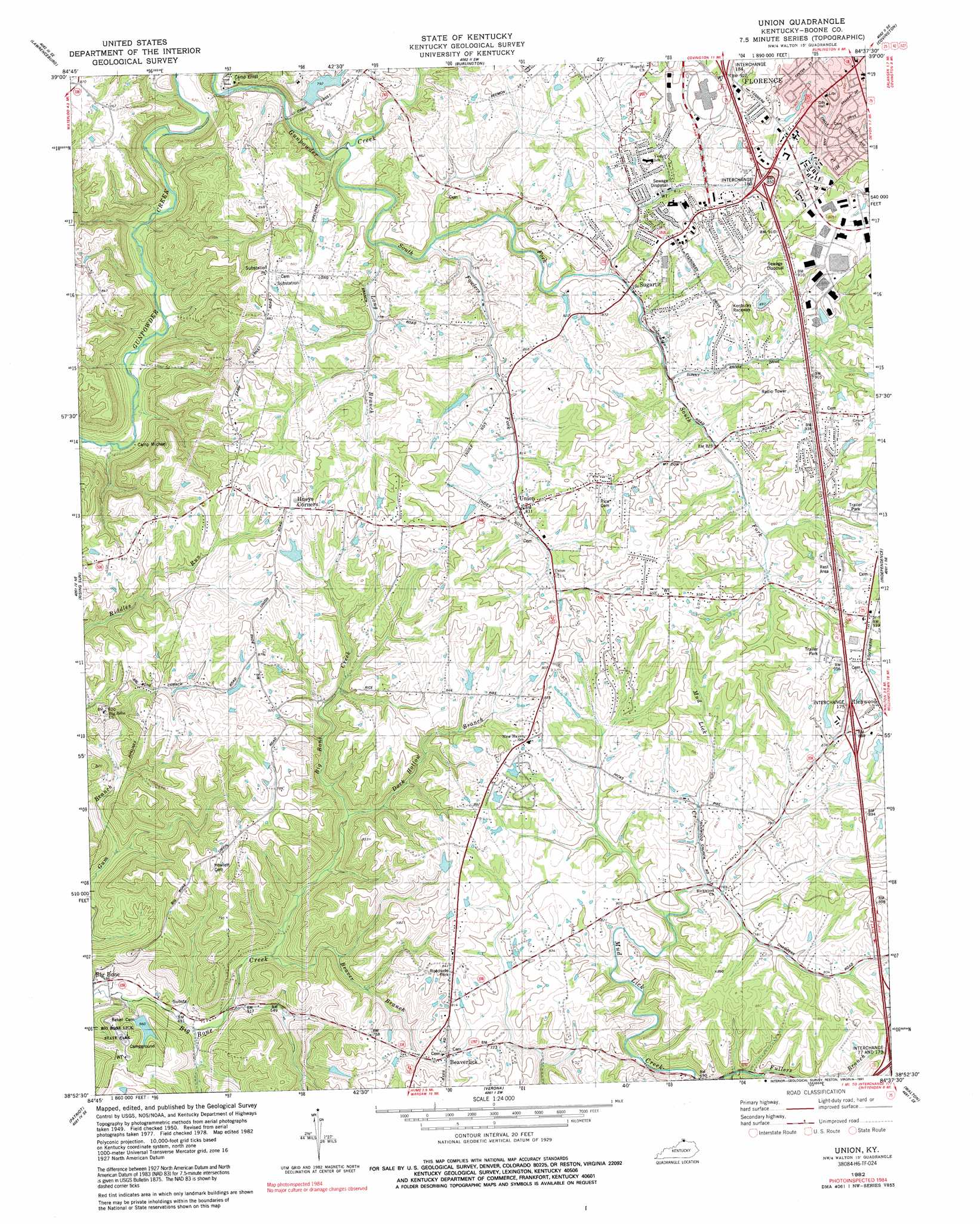
Union Topo Map Kentucky
To zoom in, hover over the map of Union
USGS Topo Quad 38084h6 - 1:24,000 scale
| Topo Map Name: | Union |
| USGS Topo Quad ID: | 38084h6 |
| Print Size: | ca. 21 1/4" wide x 27" high |
| Southeast Coordinates: | 38.875° N latitude / 84.625° W longitude |
| Map Center Coordinates: | 38.9375° N latitude / 84.6875° W longitude |
| U.S. State: | KY |
| Filename: | o38084h6.jpg |
| Download Map JPG Image: | Union topo map 1:24,000 scale |
| Map Type: | Topographic |
| Topo Series: | 7.5´ |
| Map Scale: | 1:24,000 |
| Source of Map Images: | United States Geological Survey (USGS) |
| Alternate Map Versions: |
Union KY 1950, updated 1952 Download PDF Buy paper map Union KY 1955, updated 1956 Download PDF Buy paper map Union KY 1961, updated 1962 Download PDF Buy paper map Union KY 1961, updated 1970 Download PDF Buy paper map Union KY 1982, updated 1982 Download PDF Buy paper map Union KY 1982, updated 1991 Download PDF Buy paper map Union KY 2010 Download PDF Buy paper map Union KY 2013 Download PDF Buy paper map Union KY 2016 Download PDF Buy paper map |
1:24,000 Topo Quads surrounding Union
Guilford |
Hooven |
Addyston |
Cincinnati West |
Cincinnati East |
Aurora |
Lawrenceburg |
Burlington |
Covington |
Newport |
Aberdeen |
Rising Sun |
Union |
Independence |
Alexandria |
Florence |
Patriot |
Verona |
Walton |
De Mossville |
Sanders |
Glencoe |
Elliston |
Williamstown |
Goforth |
> Back to 38084e1 at 1:100,000 scale
> Back to 38084a1 at 1:250,000 scale
> Back to U.S. Topo Maps home
Union topo map: Gazetteer
Union: Airports
Estes Airport elevation 263m 862′Union: Crossings
Interchange 173 elevation 269m 882′Interchange 175 elevation 268m 879′
Interchange 180 elevation 265m 869′
Interchange 77 elevation 269m 882′
Union: Parks
Lincoln Woods Park elevation 258m 846′South Fork Park elevation 245m 803′
Union: Populated Places
Beaverlick elevation 229m 751′Florence elevation 282m 925′
Hueys Corners elevation 280m 918′
Oakbrook elevation 265m 869′
Sugartit elevation 241m 790′
Union elevation 255m 836′
Union: Post Offices
Beaverlick Post Office (historical) elevation 223m 731′Gunpowder Post Office (historical) elevation 243m 797′
Hathaway Post Office (historical) elevation 269m 882′
Richwood Post Office (historical) elevation 283m 928′
Union: Streams
Beaver Branch elevation 157m 515′Dark Hollow Branch elevation 187m 613′
Fowlers Fork elevation 231m 757′
Fullers Branch elevation 213m 698′
Long Branch elevation 225m 738′
Snyder Branch elevation 208m 682′
South Fork Gunpowder Creek elevation 214m 702′
Union digital topo map on disk
Buy this Union topo map showing relief, roads, GPS coordinates and other geographical features, as a high-resolution digital map file on DVD: