Lawrenceburg Topo Map Kentucky
To zoom in, hover over the map of Lawrenceburg
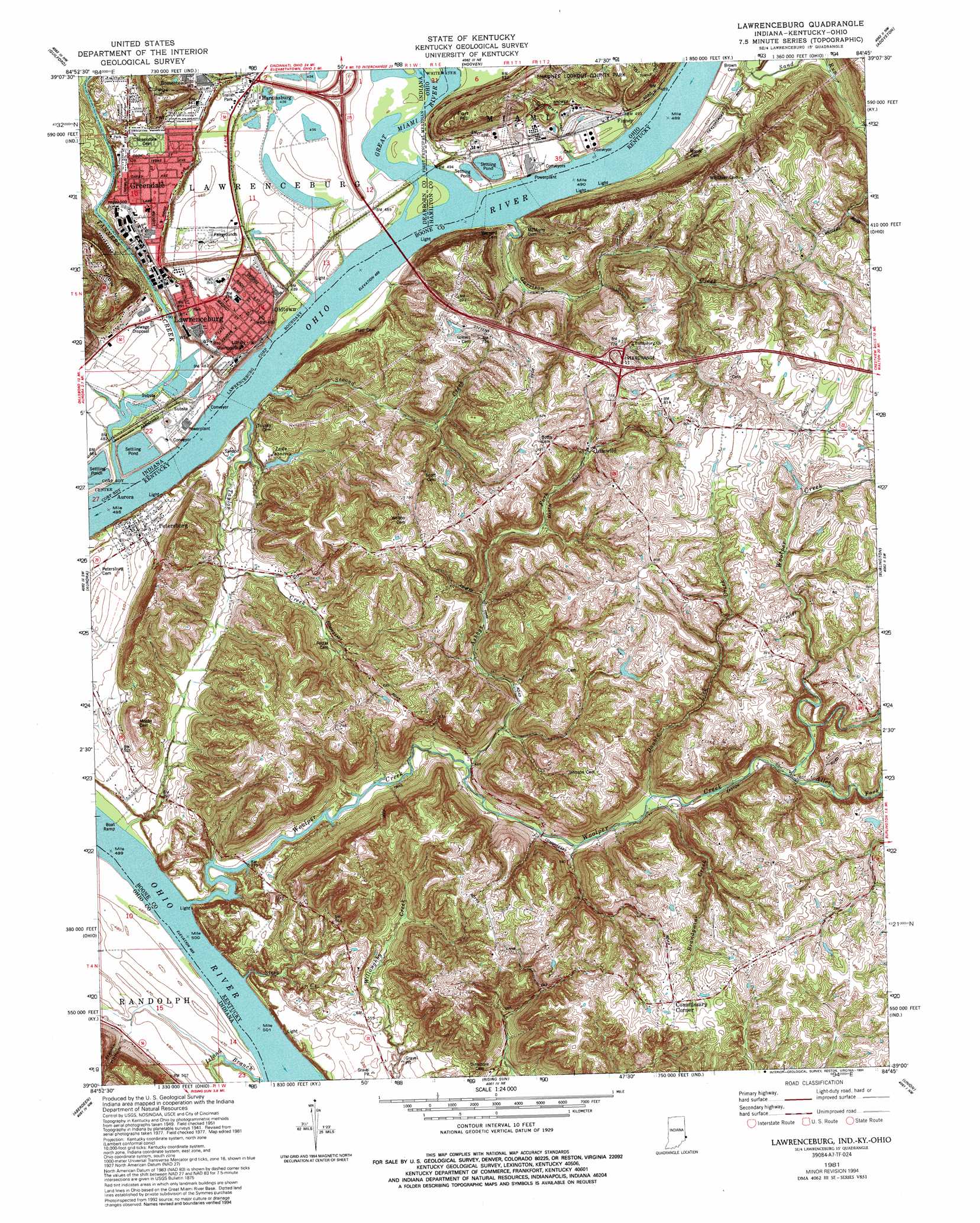
USGS Topo Quad 39084a7 - 1:24,000 scale
| Topo Map Name: | Lawrenceburg |
| USGS Topo Quad ID: | 39084a7 |
| Print Size: | ca. 21 1/4" wide x 27" high |
| Southeast Coordinates: | 39° N latitude / 84.75° W longitude |
| Map Center Coordinates: | 39.0625° N latitude / 84.8125° W longitude |
| U.S. States: | KY, IN, OH |
| Filename: | o39084a7.jpg |
| Download Map JPG Image: | Lawrenceburg topo map 1:24,000 scale |
| Map Type: | Topographic |
| Topo Series: | 7.5´ |
| Map Scale: | 1:24,000 |
| Source of Map Images: | United States Geological Survey (USGS) |
| Alternate Map Versions: |
Lawrenceburg IN 1943 Download PDF Buy paper map Lawrenceburg IN 1981, updated 1982 Download PDF Buy paper map Lawrenceburg IN 1981, updated 1991 Download PDF Buy paper map Lawrenceburg IN 1981, updated 1994 Download PDF Buy paper map Lawrenceburg IN 2010 Download PDF Buy paper map Lawrenceburg IN 2013 Download PDF Buy paper map Lawrenceburg IN 2016 Download PDF Buy paper map |
1:24,000 Topo Quads surrounding Lawrenceburg
Spades |
Cedar Grove |
Harrison |
Shandon |
Greenhills |
Sunman |
Guilford |
Hooven |
Addyston |
Cincinnati West |
Dillsboro |
Aurora |
Lawrenceburg |
Burlington |
Covington |
Bear Branch |
Aberdeen |
Rising Sun |
Union |
Independence |
Vevay North |
Florence |
Patriot |
Verona |
Walton |
> Back to 39084a1 at 1:100,000 scale
> Back to 39084a1 at 1:250,000 scale
> Back to U.S. Topo Maps home
Lawrenceburg topo map: Gazetteer
Lawrenceburg: Airports
Riverview Airport elevation 140m 459′Lawrenceburg: Crossings
Lawrenceburg Ferry (historical) elevation 146m 479′Lawrenceburg: Lakes
Lake Jeanclia elevation 150m 492′Old Channel Lake elevation 139m 456′
Lawrenceburg: Parks
Miami River Public Access Site elevation 139m 456′Lawrenceburg: Populated Places
Commissary Corner elevation 257m 843′Finney elevation 150m 492′
Greendale elevation 161m 528′
Hardinsburg elevation 148m 485′
Homestead elevation 162m 531′
Idlewild elevation 202m 662′
Lawrenceburg elevation 146m 479′
Oldtown elevation 145m 475′
Petersburg elevation 156m 511′
Lawrenceburg: Post Offices
Idlewild Post Office (historical) elevation 200m 656′Touseytown Post Office (historical) elevation 140m 459′
Lawrenceburg: Streams
Allen Fork elevation 184m 603′Ashbys Fork elevation 147m 482′
Brandywine Creek elevation 164m 538′
Dark Hollow Run elevation 139m 456′
Double Lick Creek elevation 164m 538′
Doublelick Run elevation 140m 459′
Garrison Creek elevation 141m 462′
Great Miami River elevation 137m 449′
Island Branch elevation 140m 459′
Peaks Branch elevation 137m 449′
Second Creek elevation 140m 459′
Steep Creek elevation 139m 456′
Tanners Creek elevation 140m 459′
Taylor Creek elevation 140m 459′
Whitewater River elevation 138m 452′
Woolper Creek elevation 139m 456′
Lawrenceburg: Summits
Fort Hill elevation 226m 741′Ludlow Hill elevation 237m 777′
Lawrenceburg: Valleys
Dark Hollow elevation 141m 462′French Hollow elevation 151m 495′
Lawrenceburg digital topo map on disk
Buy this Lawrenceburg topo map showing relief, roads, GPS coordinates and other geographical features, as a high-resolution digital map file on DVD:
Northern Illinois, Northern Indiana & Southwestern Michigan
Buy digital topo maps: Northern Illinois, Northern Indiana & Southwestern Michigan