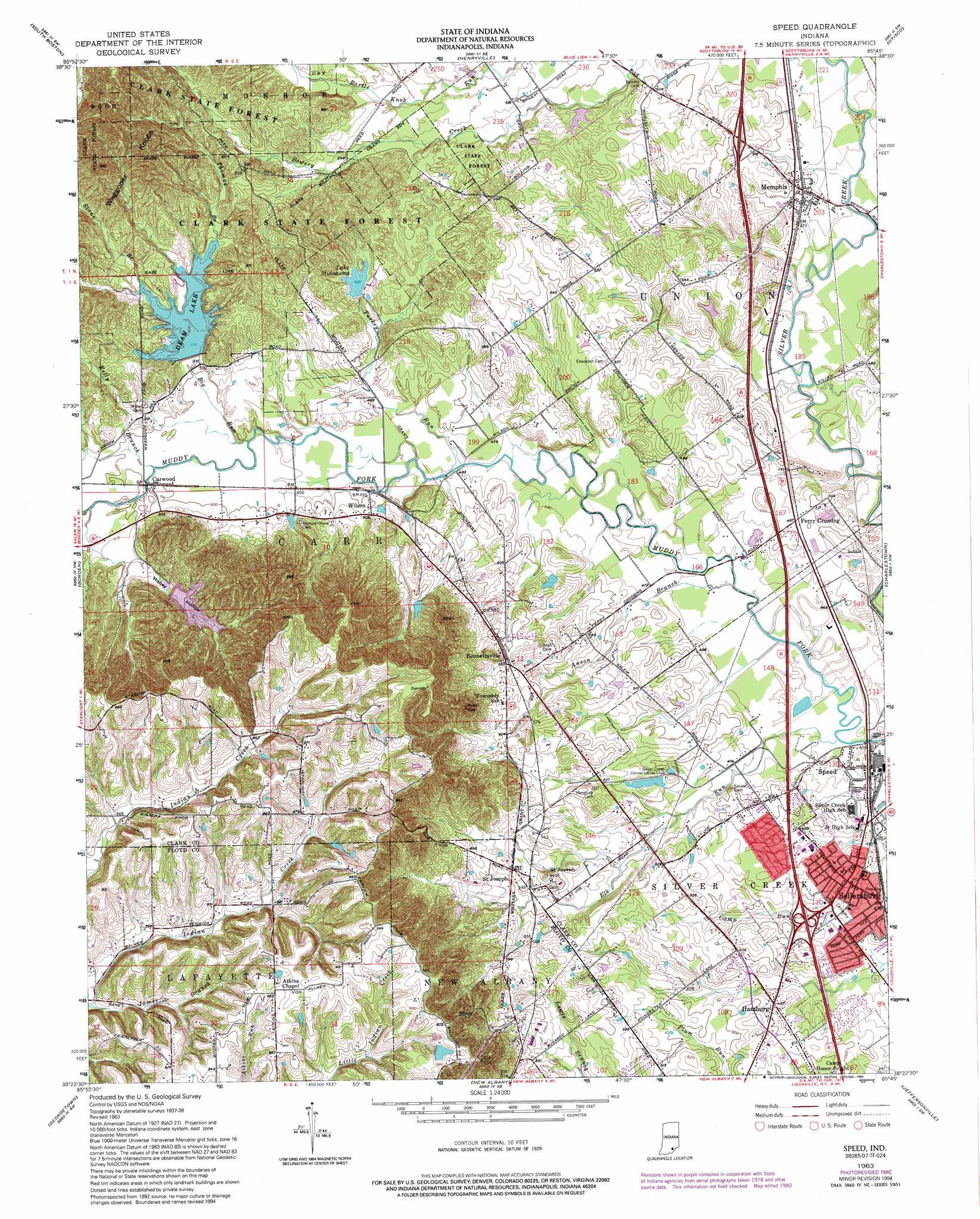
Speed Topo Map Indiana
To zoom in, hover over the map of Speed
USGS Topo Quad 38085d7 - 1:24,000 scale
| Topo Map Name: | Speed |
| USGS Topo Quad ID: | 38085d7 |
| Print Size: | ca. 21 1/4" wide x 27" high |
| Southeast Coordinates: | 38.375° N latitude / 85.75° W longitude |
| Map Center Coordinates: | 38.4375° N latitude / 85.8125° W longitude |
| U.S. State: | IN |
| Filename: | o38085d7.jpg |
| Download Map JPG Image: | Speed topo map 1:24,000 scale |
| Map Type: | Topographic |
| Topo Series: | 7.5´ |
| Map Scale: | 1:24,000 |
| Source of Map Images: | United States Geological Survey (USGS) |
| Alternate Map Versions: |
Speed IN 1938 Download PDF Buy paper map Speed IN 1947 Download PDF Buy paper map Speed IN 1957, updated 1958 Download PDF Buy paper map Speed IN 1963, updated 1965 Download PDF Buy paper map Speed IN 1963, updated 1974 Download PDF Buy paper map Speed IN 1963, updated 1981 Download PDF Buy paper map Speed IN 1963, updated 1994 Download PDF Buy paper map Speed IN 1963, updated 1994 Download PDF Buy paper map Speed IN 2010 Download PDF Buy paper map Speed IN 2013 Download PDF Buy paper map Speed IN 2016 Download PDF Buy paper map |
1:24,000 Topo Quads surrounding Speed
Kossuth |
Little York |
Scottsburg |
Blocher |
Kent |
Salem |
South Boston |
Henryville |
Otisco |
New Washington |
Palmyra |
Borden |
Speed |
Charlestown |
Owen |
Crandall |
Georgetown |
New Albany |
Jeffersonville |
Anchorage |
Corydon East |
Lanesville |
Louisville West |
Louisville East |
Jeffersontown |
> Back to 38085a1 at 1:100,000 scale
> Back to 38084a1 at 1:250,000 scale
> Back to U.S. Topo Maps home
Speed topo map: Gazetteer
Speed: Dams
Dream Lake Dam elevation 179m 587′Lake Hideaway Dam elevation 158m 518′
Southern Hills Lake Dam elevation 164m 538′
Ulrich Lake Dam elevation 291m 954′
Speed: Parks
Camp Honor Bright elevation 151m 495′Deam Lake State Recreation Area elevation 163m 534′
Speed: Populated Places
Bennettsville elevation 174m 570′Carwood elevation 152m 498′
Hamburg elevation 148m 485′
Memphis elevation 148m 485′
Perry Crossing elevation 152m 498′
Saint Joseph elevation 172m 564′
Sellersburg elevation 148m 485′
Slatecut elevation 149m 488′
Speed elevation 144m 472′
Wilson elevation 155m 508′
Speed: Post Offices
Memphis Post Office elevation 149m 488′Sellersburg Post Office elevation 145m 475′
Speed: Reservoirs
Deam Lake elevation 155m 508′Dream Lake elevation 179m 587′
Lake Hideaway elevation 158m 518′
Ulrich Lake elevation 285m 935′
Speed: Ridges
Waggoner Knobs elevation 290m 951′Speed: Streams
Anson Branch elevation 140m 459′Bartle Knob Run elevation 158m 518′
Big Run elevation 149m 488′
Bowery Creek elevation 170m 557′
Elk Run elevation 139m 456′
James Branch elevation 234m 767′
Kelly Branch elevation 149m 488′
Stone Branch elevation 164m 538′
Thomas Branch elevation 165m 541′
Turkey Run elevation 146m 479′
Speed: Summits
Saint Joseph Hill elevation 178m 583′Speed: Valleys
Money Hollow elevation 159m 521′Speed digital topo map on disk
Buy this Speed topo map showing relief, roads, GPS coordinates and other geographical features, as a high-resolution digital map file on DVD: