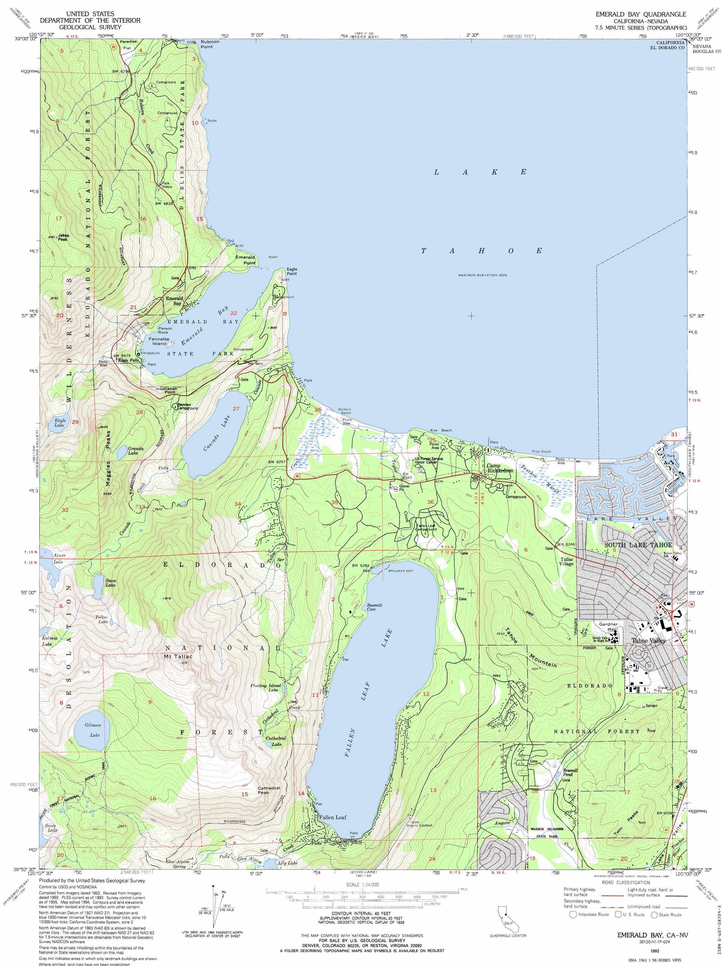
Emerald Bay Topo Map California
To zoom in, hover over the map of Emerald Bay
USGS Topo Quad 38120h1 - 1:24,000 scale
| Topo Map Name: | Emerald Bay |
| USGS Topo Quad ID: | 38120h1 |
| Print Size: | ca. 21 1/4" wide x 27" high |
| Southeast Coordinates: | 38.875° N latitude / 120° W longitude |
| Map Center Coordinates: | 38.9375° N latitude / 120.0625° W longitude |
| U.S. State: | CA |
| Filename: | o38120h1.jpg |
| Download Map JPG Image: | Emerald Bay topo map 1:24,000 scale |
| Map Type: | Topographic |
| Topo Series: | 7.5´ |
| Map Scale: | 1:24,000 |
| Source of Map Images: | United States Geological Survey (USGS) |
| Alternate Map Versions: |
Emerald Bay CA 1955, updated 1957 Download PDF Buy paper map Emerald Bay CA 1955, updated 1960 Download PDF Buy paper map Emerald Bay CA 1955, updated 1960 Download PDF Buy paper map Emerald Bay CA 1955, updated 1971 Download PDF Buy paper map Emerald Bay CA 1955, updated 1971 Download PDF Buy paper map Emerald Bay CA 1992, updated 1994 Download PDF Buy paper map Emerald Bay CA 2012 Download PDF Buy paper map Emerald Bay CA 2015 Download PDF Buy paper map |
| FStopo: | US Forest Service topo Emerald Bay is available: Download FStopo PDF Download FStopo TIF |
1:24,000 Topo Quads surrounding Emerald Bay
Granite Chief |
Tahoe City |
Kings Beach |
Marlette Lake |
Carson City |
Wentworth Springs |
Homewood |
Meeks Bay |
Glenbrook |
Genoa |
Loon Lake |
Rockbound Valley |
Emerald Bay |
South Lake Tahoe |
Minden |
Kyburz |
Pyramid Peak |
Echo Lake |
Freel Peak |
Woodfords |
Leek Spring Hill |
Tragedy Spring |
Caples Lake |
Carson Pass |
Markleeville |
> Back to 38120e1 at 1:100,000 scale
> Back to 38120a1 at 1:250,000 scale
> Back to U.S. Topo Maps home
Emerald Bay topo map: Gazetteer
Emerald Bay: Bays
Emerald Bay elevation 1900m 6233′Sawmill Core elevation 1945m 6381′
Emerald Bay: Beaches
Baldwin Beach elevation 1899m 6230′Calawee Cove Beach elevation 1902m 6240′
Kiva Beach elevation 1900m 6233′
Pope Beach elevation 1900m 6233′
Emerald Bay: Capes
Eagle Point elevation 1900m 6233′Emerald Point elevation 1900m 6233′
Rubicon Point elevation 1918m 6292′
Emerald Bay: Cliffs
Cathedral Peak elevation 2551m 8369′Tallac Point elevation 1901m 6236′
Emerald Bay: Dams
Fallen Leaf Dam elevation 1941m 6368′Emerald Bay: Falls
Eagle Falls elevation 1989m 6525′Emerald Bay: Islands
Fannette Island elevation 1931m 6335′Tahoe Keys elevation 1898m 6227′
Emerald Bay: Lakes
Azure Lake elevation 2345m 7693′Cascade Lake elevation 1967m 6453′
Cathedral Lake elevation 2325m 7627′
Eagle Lake elevation 2131m 6991′
Floating Island Lake elevation 2203m 7227′
Gilmore Lake elevation 2536m 8320′
Granite Lake elevation 2334m 7657′
Lily Lake elevation 1993m 6538′
Snow Lake elevation 2253m 7391′
Tallac Lake elevation 2411m 7910′
Emerald Bay: Parks
D.L. Bliss State Park elevation 1984m 6509′Emerald Bay State Park elevation 1900m 6233′
Fallen Leaf Recreation Center elevation 1957m 6420′
Tallac Historical Site elevation 1903m 6243′
Washoe Meadows State Park elevation 1922m 6305′
Emerald Bay: Pillars
Balance Rock elevation 1944m 6377′Parson Rock elevation 1904m 6246′
Emerald Bay: Populated Places
Camp Richardson elevation 1905m 6250′Emerald Bay elevation 1926m 6318′
Fallen Leaf elevation 1959m 6427′
Kiva Beach elevation 1902m 6240′
Lake Valley elevation 1892m 6207′
Spring Creek elevation 1932m 6338′
Tahoe Keys elevation 1902m 6240′
Tahoe Valley elevation 1911m 6269′
Tallac Village elevation 1909m 6263′
Emerald Bay: Post Offices
Camp Richardson Post Office elevation 1907m 6256′Fallen Leaf Post Office (historical) elevation 1959m 6427′
Emerald Bay: Reservoirs
Fallen Leaf Lake elevation 1941m 6368′Fallen Leaf Lake elevation 1948m 6391′
Sawmill Pond elevation 1935m 6348′
Emerald Bay: Springs
Glen Alpine Spring elevation 2078m 6817′Emerald Bay: Streams
Cascade Creek elevation 1900m 6233′Cathedral Creek elevation 1945m 6381′
Glen Alpine Creek elevation 1950m 6397′
Tallac Creek elevation 1900m 6233′
Taylor Creek elevation 1901m 6236′
Emerald Bay: Summits
Gardner Mountain elevation 1944m 6377′Inspiration Point elevation 2081m 6827′
Jakes Peak elevation 2797m 9176′
Maggies Peaks elevation 2639m 8658′
Mount Tallac elevation 2965m 9727′
Tahoe Mountain elevation 2205m 7234′
Twin Peaks elevation 2066m 6778′
Emerald Bay: Trails
Balancing Rock Self-Guided Nature Trail elevation 1944m 6377′Eagle Falls Trail elevation 1920m 6299′
Lighthouse Trail elevation 1976m 6482′
Rubicon Trail elevation 1900m 6233′
Vikingsholm Trail elevation 1971m 6466′
Emerald Bay digital topo map on disk
Buy this Emerald Bay topo map showing relief, roads, GPS coordinates and other geographical features, as a high-resolution digital map file on DVD: