Williamsburg Topo Map Ohio
To zoom in, hover over the map of Williamsburg
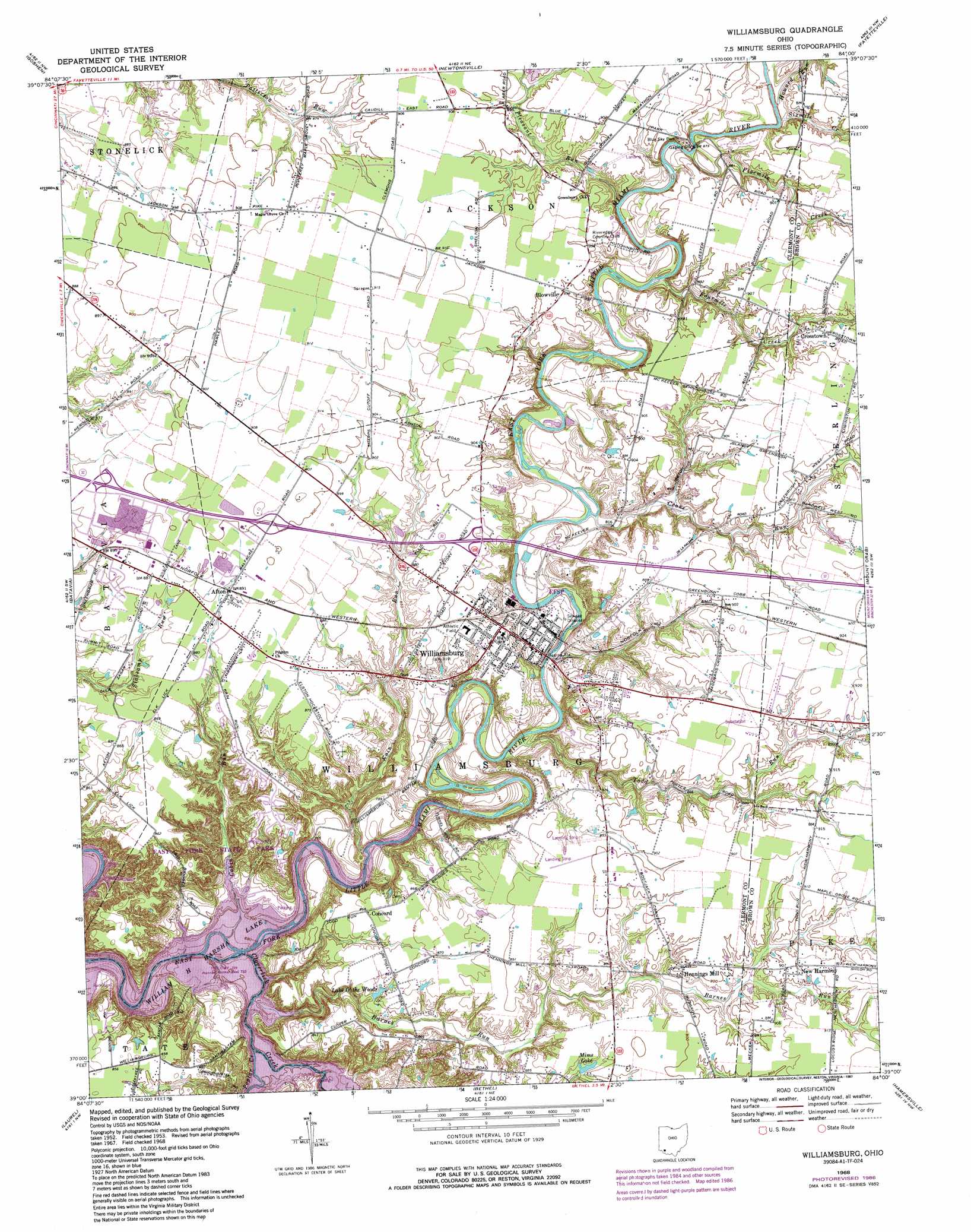
USGS Topo Quad 39084a1 - 1:24,000 scale
| Topo Map Name: | Williamsburg |
| USGS Topo Quad ID: | 39084a1 |
| Print Size: | ca. 21 1/4" wide x 27" high |
| Southeast Coordinates: | 39° N latitude / 84° W longitude |
| Map Center Coordinates: | 39.0625° N latitude / 84.0625° W longitude |
| U.S. State: | OH |
| Filename: | o39084a1.jpg |
| Download Map JPG Image: | Williamsburg topo map 1:24,000 scale |
| Map Type: | Topographic |
| Topo Series: | 7.5´ |
| Map Scale: | 1:24,000 |
| Source of Map Images: | United States Geological Survey (USGS) |
| Alternate Map Versions: |
Williamsburg OH 1953, updated 1955 Download PDF Buy paper map Williamsburg OH 1953, updated 1967 Download PDF Buy paper map Williamsburg OH 1968, updated 1970 Download PDF Buy paper map Williamsburg OH 1968, updated 1976 Download PDF Buy paper map Williamsburg OH 1968, updated 1982 Download PDF Buy paper map Williamsburg OH 1968, updated 1987 Download PDF Buy paper map Williamsburg OH 2010 Download PDF Buy paper map Williamsburg OH 2013 Download PDF Buy paper map Williamsburg OH 2016 Download PDF Buy paper map |
1:24,000 Topo Quads surrounding Williamsburg
Mason |
South Lebanon |
Pleasant Plain |
Blanchester |
Martinsville |
Madeira |
Goshen |
Newtonsville |
Fayetteville |
Lynchburg |
Withamsville |
Batavia |
Williamsburg |
Mount Orab |
Sardinia |
New Richmond |
Laurel |
Bethel |
Hamersville |
Ash Ridge |
Butler |
Moscow |
Felicity |
Higginsport |
Russellville |
> Back to 39084a1 at 1:100,000 scale
> Back to 39084a1 at 1:250,000 scale
> Back to U.S. Topo Maps home
Williamsburg topo map: Gazetteer
Williamsburg: Airports
Creager Airport elevation 271m 889′Williamsburg: Bridges
Twin Bridges elevation 207m 679′Williamsburg: Dams
Dela Pama Fishing Lake Dam elevation 256m 839′Williamsburg: Lakes
Lake O' the Woods elevation 258m 846′Williamsburg: Parks
Blue Sky Park elevation 270m 885′East Fork State Park elevation 252m 826′
East Fork Wildlife Area elevation 250m 820′
Williamsburg: Populated Places
Afton elevation 271m 889′Blowville elevation 273m 895′
Concord elevation 263m 862′
Crosstown elevation 278m 912′
Hennings Mill elevation 273m 895′
New Harmony elevation 277m 908′
Williamsburg elevation 248m 813′
Williamsburg: Post Offices
Afton Post Office (historical) elevation 271m 889′Blowville Post Office (historical) elevation 271m 889′
Crosstown Post Office (historical) elevation 277m 908′
Hennings Mill Post Office (historical) elevation 274m 898′
New Harmony Post Office (historical) elevation 277m 908′
Williamsburg Post Office elevation 247m 810′
Williamsburg: Reservoirs
Dela Pama Fishing Lake elevation 256m 839′Mims Lake elevation 265m 869′
Williamsburg: Streams
Barnes Run elevation 227m 744′Cabin Run elevation 207m 679′
Cloverlick Creek elevation 207m 679′
Crane Run elevation 248m 813′
Fivemile Creek elevation 260m 853′
Fourmile Creek elevation 256m 839′
Howard Run elevation 263m 862′
Kain Run elevation 218m 715′
Pleasant Run elevation 259m 849′
Poplar Creek elevation 210m 688′
Sixmile Creek elevation 262m 859′
Todd Run elevation 235m 770′
Williamsburg digital topo map on disk
Buy this Williamsburg topo map showing relief, roads, GPS coordinates and other geographical features, as a high-resolution digital map file on DVD:
Northern Illinois, Northern Indiana & Southwestern Michigan
Buy digital topo maps: Northern Illinois, Northern Indiana & Southwestern Michigan