Georgetta Ranch Topo Map Nevada
To zoom in, hover over the map of Georgetta Ranch
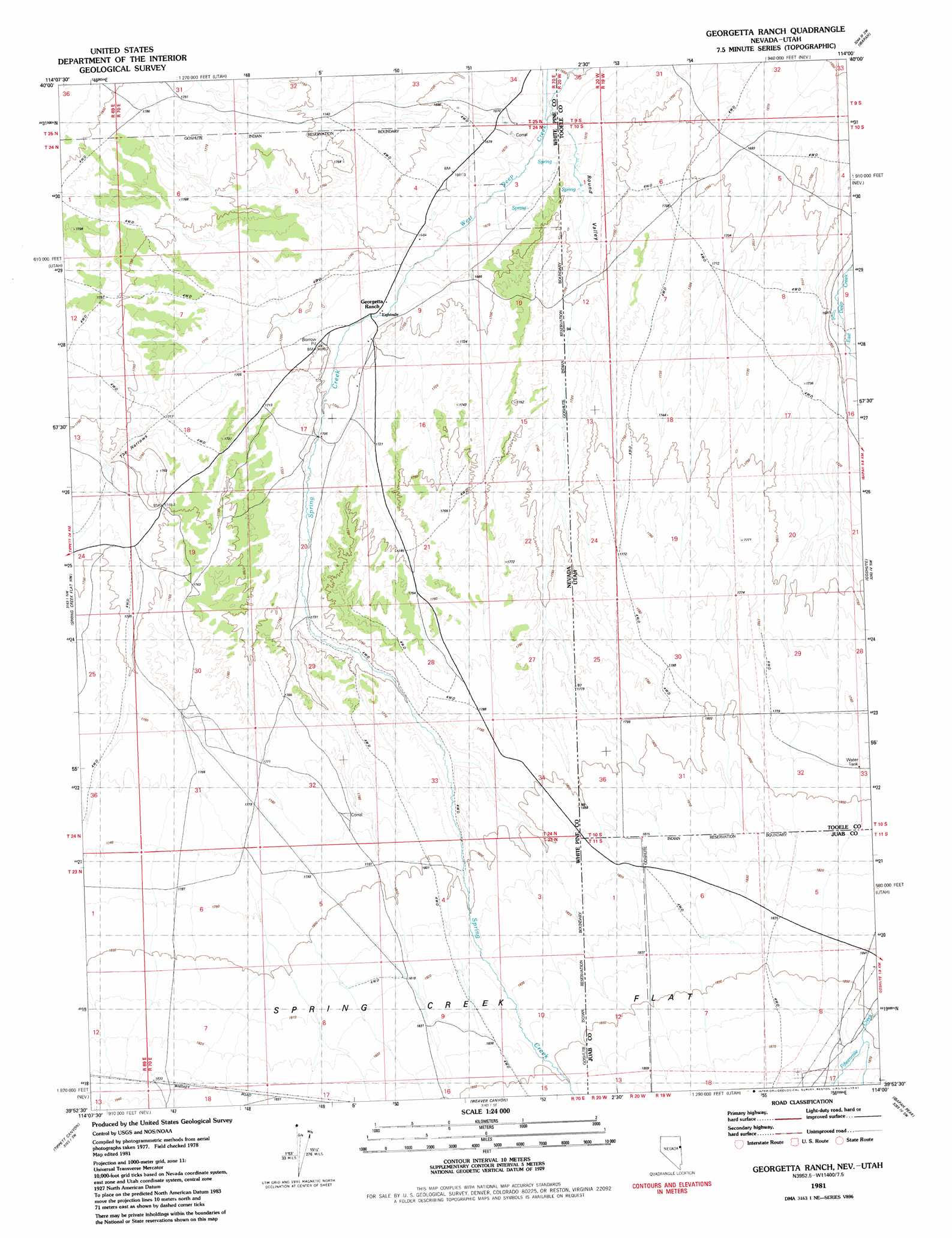
USGS Topo Quad 39114h1 - 1:24,000 scale
| Topo Map Name: | Georgetta Ranch |
| USGS Topo Quad ID: | 39114h1 |
| Print Size: | ca. 21 1/4" wide x 27" high |
| Southeast Coordinates: | 39.875° N latitude / 114° W longitude |
| Map Center Coordinates: | 39.9375° N latitude / 114.0625° W longitude |
| U.S. States: | NV, UT |
| Filename: | o39114h1.jpg |
| Download Map JPG Image: | Georgetta Ranch topo map 1:24,000 scale |
| Map Type: | Topographic |
| Topo Series: | 7.5´ |
| Map Scale: | 1:24,000 |
| Source of Map Images: | United States Geological Survey (USGS) |
| Alternate Map Versions: |
Georgetta Ranch NV 1981, updated 1981 Download PDF Buy paper map Georgetta Ranch NV 2012 Download PDF Buy paper map Georgetta Ranch NV 2014 Download PDF Buy paper map |
1:24,000 Topo Quads surrounding Georgetta Ranch
Kinsley Mountain |
Ferber Peak Nw |
Ferber Peak |
Ochre Mountain |
Gold Hill |
Chin Creek Reservoir |
Ayarbe Spring |
Ferber Peak Se |
Ibapah |
Clifton |
Sunset Reservoir |
Spring Creek Flat Nw |
Georgetta Ranch |
Goshute |
Goshute Canyon |
Tippett |
Tippett Canyon |
Weaver Canyon |
Ibapah Peak |
Indian Farm Creek |
Grass Valley Wash |
Blue Mass Canyon |
Skinner Canyon |
Partoun |
Trout Creek |
> Back to 39114e1 at 1:100,000 scale
> Back to 39114a1 at 1:250,000 scale
> Back to U.S. Topo Maps home
Georgetta Ranch topo map: Gazetteer
Georgetta Ranch: Dams
Goshute Dam elevation 1748m 5734′Georgetta Ranch: Flats
Spring Creek Flat elevation 1831m 6007′Spring Creek Flat elevation 1830m 6003′
Georgetta Ranch: Gaps
The Narrows elevation 1728m 5669′Georgetta Ranch: Mines
Wide West Mine elevation 1883m 6177′Georgetta Ranch: Populated Places
Goshute elevation 1884m 6181′Georgetta Ranch: Reservoirs
Goshute Reservoir elevation 1748m 5734′Georgetta Ranch: Streams
Fifteenmile Creek elevation 1694m 5557′Spring Creek elevation 1650m 5413′
Spring Creek elevation 1684m 5524′
Weaver Creek elevation 1738m 5702′
Georgetta Ranch: Valleys
Round Valley elevation 1691m 5547′Georgetta Ranch digital topo map on disk
Buy this Georgetta Ranch topo map showing relief, roads, GPS coordinates and other geographical features, as a high-resolution digital map file on DVD: