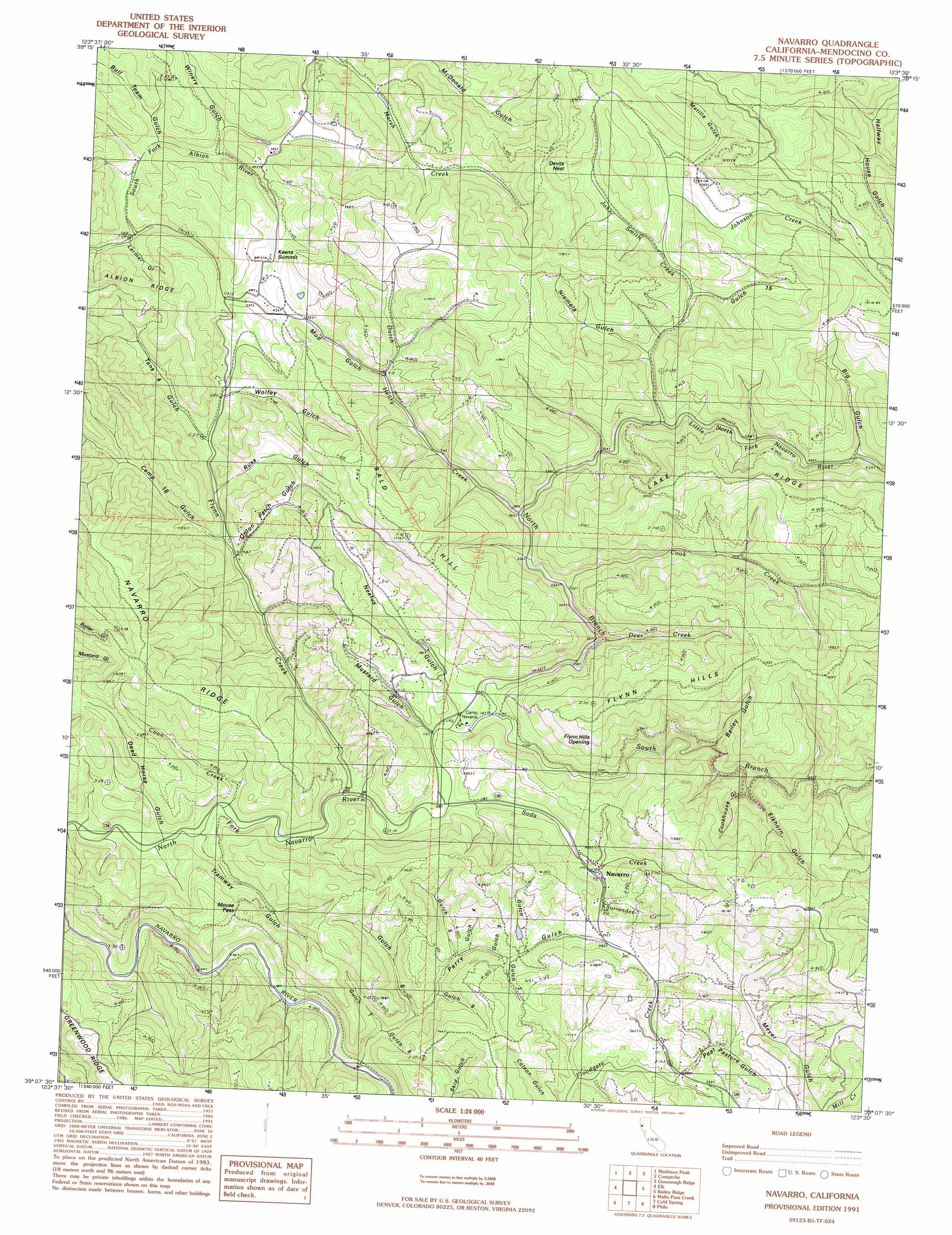
Navarro Topo Map California
To zoom in, hover over the map of Navarro
USGS Topo Quad 39123b5 - 1:24,000 scale
| Topo Map Name: | Navarro |
| USGS Topo Quad ID: | 39123b5 |
| Print Size: | ca. 21 1/4" wide x 27" high |
| Southeast Coordinates: | 39.125° N latitude / 123.5° W longitude |
| Map Center Coordinates: | 39.1875° N latitude / 123.5625° W longitude |
| U.S. State: | CA |
| Filename: | o39123b5.jpg |
| Download Map JPG Image: | Navarro topo map 1:24,000 scale |
| Map Type: | Topographic |
| Topo Series: | 7.5´ |
| Map Scale: | 1:24,000 |
| Source of Map Images: | United States Geological Survey (USGS) |
| Alternate Map Versions: |
Navarro CA 1991, updated 1991 Download PDF Buy paper map Navarro CA 2012 Download PDF Buy paper map Navarro CA 2015 Download PDF Buy paper map |
1:24,000 Topo Quads surrounding Navarro
Fort Bragg |
Noyo Hill |
Northspur |
Burbeck |
Willits |
Mendocino |
Mathison Peak |
Comptche |
Greenough Ridge |
Laughlin Range |
Albion |
Elk |
Navarro |
Bailey Ridge |
Orrs Springs |
Mallo Pass Creek |
Cold Spring |
Philo |
Boonville |
|
Point Arena |
Eureka Hill |
Zeni Ridge |
Ornbaun Valley |
> Back to 39123a1 at 1:100,000 scale
> Back to 39122a1 at 1:250,000 scale
> Back to U.S. Topo Maps home
Navarro topo map: Gazetteer
Navarro: Flats
Devils Nest elevation 151m 495′Navarro: Gaps
Flynn Hills Opening elevation 312m 1023′Keene Summit elevation 155m 508′
Mouse Pass elevation 154m 505′
Navarro: Populated Places
Navarro elevation 82m 269′Navarro: Ranges
Flynn Hills elevation 308m 1010′Navarro: Ridges
Lake Ridge elevation 340m 1115′Navarro: Streams
Cook Creek elevation 65m 213′Coon Creek elevation 18m 59′
Deer Creek elevation 108m 354′
Dutch Henry Creek elevation 81m 265′
Flynn Creek elevation 23m 75′
John Smith Creek elevation 113m 370′
Johnson Creek elevation 147m 482′
Little North Fork Navarro River elevation 113m 370′
North Branch North Fork Navarro River elevation 36m 118′
Redwood Creek elevation 150m 492′
Soda Creek elevation 28m 91′
South Branch North Fork Navarro River elevation 35m 114′
Surrender Creek elevation 86m 282′
Navarro: Summits
Bald Hill elevation 371m 1217′Navarro: Trails
Sheep Trail elevation 227m 744′Navarro: Valleys
Bailey Gulch elevation 95m 311′Big Gulch elevation 126m 413′
Bull Team Gulch elevation 77m 252′
Camp Sixteen Gulch elevation 53m 173′
Cookhouse Gulch elevation 90m 295′
Dead Horse Gulch elevation 15m 49′
Elkhorn Gulch elevation 86m 282′
Gulch Eight elevation 30m 98′
Gulch Fifteen elevation 116m 380′
Gulch Five elevation 48m 157′
Gulch Four elevation 56m 183′
Gulch Nine elevation 60m 196′
Gulch One elevation 73m 239′
Gulch Seven elevation 41m 134′
Gulch Six elevation 35m 114′
Gulch Three elevation 72m 236′
Gulch Two elevation 72m 236′
Halfway House Gulch elevation 126m 413′
Larmer Gulch elevation 56m 183′
Matilla Gulch elevation 161m 528′
Mud Gulch elevation 111m 364′
Mustard Gulch elevation 34m 111′
Neefus Gulch elevation 37m 121′
Niemela Gulch elevation 106m 347′
Onion Patch Gulch elevation 49m 160′
Peat Pasture Gulch elevation 58m 190′
Perry Gulch elevation 18m 59′
Russ Gulch elevation 60m 196′
Tank Four Gulch elevation 69m 226′
Tramway Gulch elevation 21m 68′
Winery Gulch elevation 110m 360′
Wolfey Gulch elevation 73m 239′
Navarro digital topo map on disk
Buy this Navarro topo map showing relief, roads, GPS coordinates and other geographical features, as a high-resolution digital map file on DVD: