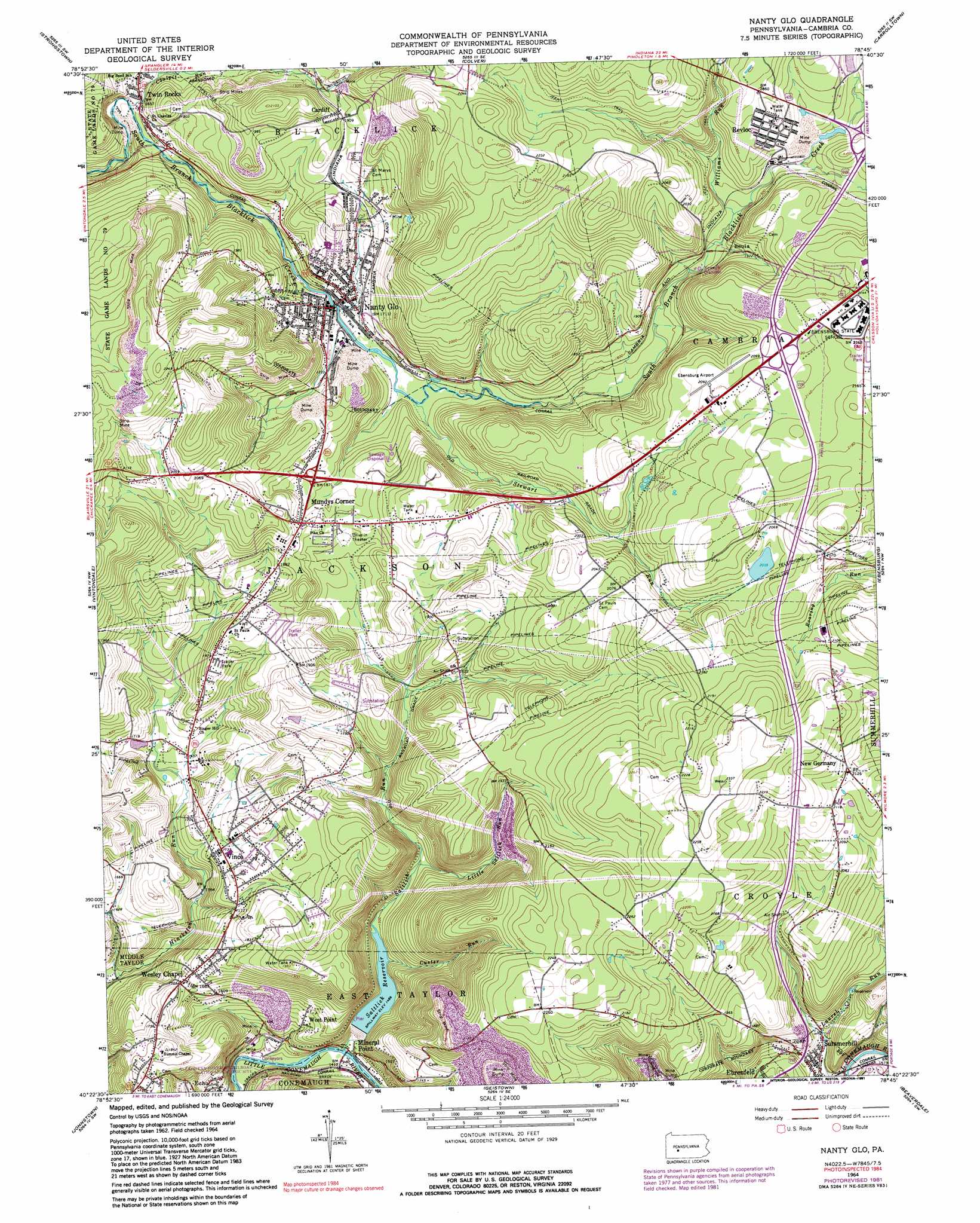
Nanty Glo Topo Map Pennsylvania
To zoom in, hover over the map of Nanty Glo
USGS Topo Quad 40078d7 - 1:24,000 scale
| Topo Map Name: | Nanty Glo |
| USGS Topo Quad ID: | 40078d7 |
| Print Size: | ca. 21 1/4" wide x 27" high |
| Southeast Coordinates: | 40.375° N latitude / 78.75° W longitude |
| Map Center Coordinates: | 40.4375° N latitude / 78.8125° W longitude |
| U.S. State: | PA |
| Filename: | o40078d7.jpg |
| Download Map JPG Image: | Nanty Glo topo map 1:24,000 scale |
| Map Type: | Topographic |
| Topo Series: | 7.5´ |
| Map Scale: | 1:24,000 |
| Source of Map Images: | United States Geological Survey (USGS) |
| Alternate Map Versions: |
Nanty Glo PA 1964, updated 1966 Download PDF Buy paper map Nanty Glo PA 1964, updated 1973 Download PDF Buy paper map Nanty Glo PA 1964, updated 1982 Download PDF Buy paper map Nanty Glo PA 1964, updated 1991 Download PDF Buy paper map Nanty Glo PA 2010 Download PDF Buy paper map Nanty Glo PA 2013 Download PDF Buy paper map Nanty Glo PA 2016 Download PDF Buy paper map |
1:24,000 Topo Quads surrounding Nanty Glo
Clymer |
Commodore |
Barnesboro |
Hastings |
Coalport |
Brush Valley |
Strongstown |
Colver |
Carrolltown |
Ashville |
New Florence |
Vintondale |
Nanty Glo |
Ebensburg |
Cresson |
Rachelwood |
Johnstown |
Geistown |
Beaverdale |
Blue Knob |
Boswell |
Hooversville |
Windber |
Ogletown |
Alum Bank |
> Back to 40078a1 at 1:100,000 scale
> Back to 40078a1 at 1:250,000 scale
> Back to U.S. Topo Maps home
Nanty Glo topo map: Gazetteer
Nanty Glo: Airports
Ebensburg Airport elevation 637m 2089′Nanty Glo: Dams
Greater Johnstown Water Authority Dam elevation 436m 1430′Natcher Dam elevation 586m 1922′
Nanty Glo: Populated Places
Beula elevation 571m 1873′Cardiff elevation 575m 1886′
Echo elevation 484m 1587′
Mineral Point elevation 420m 1377′
Mundys Corner elevation 576m 1889′
Nanty Glo elevation 534m 1751′
New Germany elevation 649m 2129′
Revloc elevation 630m 2066′
Summerhill elevation 488m 1601′
Twin Rocks elevation 504m 1653′
Vinco elevation 528m 1732′
Wesley Chapel elevation 519m 1702′
West Point elevation 465m 1525′
Nanty Glo: Post Offices
Expedit Post Office (historical) elevation 504m 1653′Vinco Post Office (historical) elevation 528m 1732′
Nanty Glo: Reservoirs
Clear Spring Lake elevation 586m 1922′Saltlick Reservoir elevation 453m 1486′
Nanty Glo: Streams
Coalpit Run elevation 501m 1643′Custer Run elevation 456m 1496′
Little Saltlick Run elevation 474m 1555′
Saltlick Run elevation 418m 1371′
Stewart Run elevation 523m 1715′
Williams Run elevation 564m 1850′
Nanty Glo digital topo map on disk
Buy this Nanty Glo topo map showing relief, roads, GPS coordinates and other geographical features, as a high-resolution digital map file on DVD:
 map DVD")