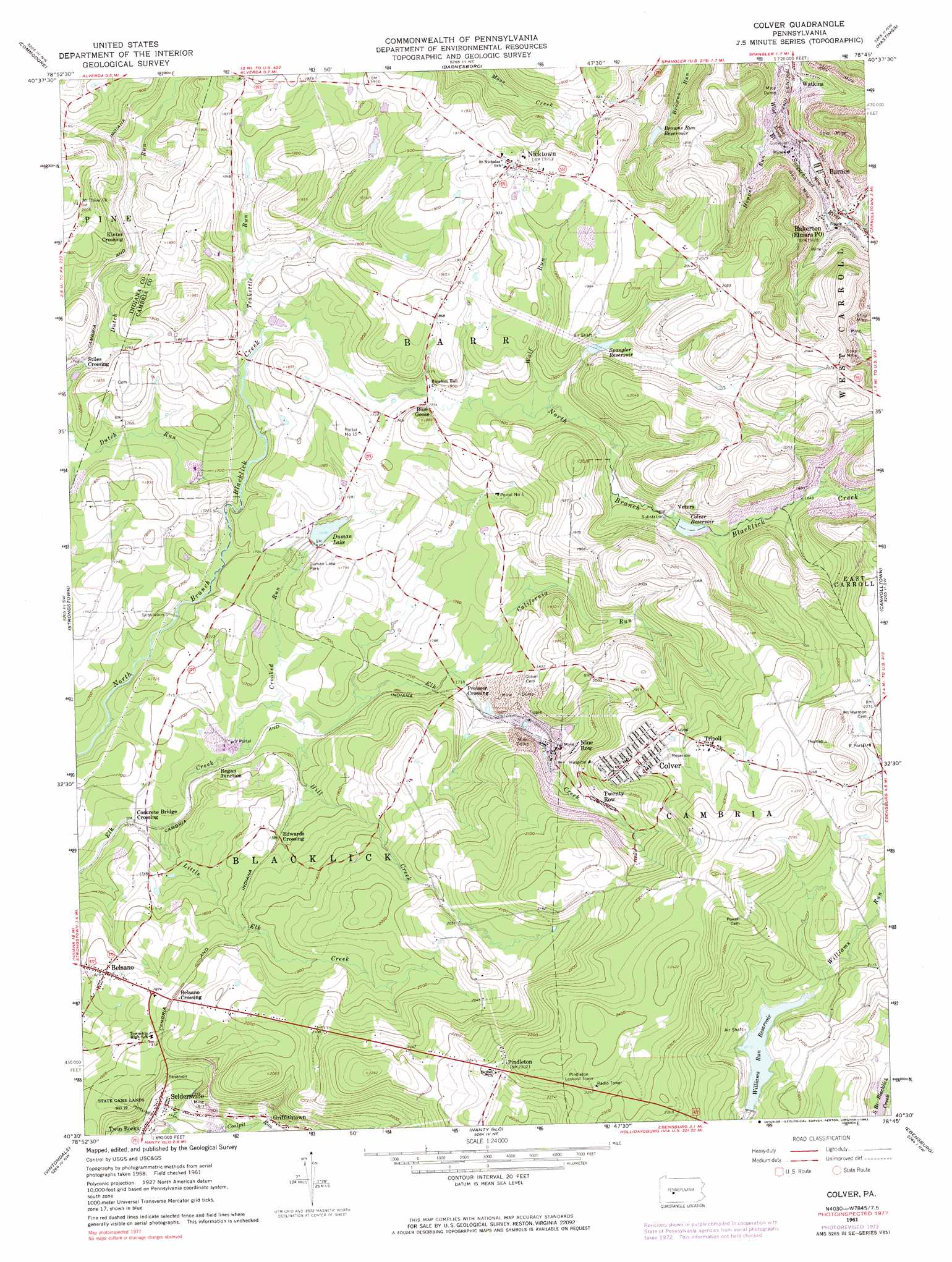
Colver Topo Map Pennsylvania
To zoom in, hover over the map of Colver
USGS Topo Quad 40078e7 - 1:24,000 scale
| Topo Map Name: | Colver |
| USGS Topo Quad ID: | 40078e7 |
| Print Size: | ca. 21 1/4" wide x 27" high |
| Southeast Coordinates: | 40.5° N latitude / 78.75° W longitude |
| Map Center Coordinates: | 40.5625° N latitude / 78.8125° W longitude |
| U.S. State: | PA |
| Filename: | o40078e7.jpg |
| Download Map JPG Image: | Colver topo map 1:24,000 scale |
| Map Type: | Topographic |
| Topo Series: | 7.5´ |
| Map Scale: | 1:24,000 |
| Source of Map Images: | United States Geological Survey (USGS) |
| Alternate Map Versions: |
Colver PA 1961, updated 1963 Download PDF Buy paper map Colver PA 1961, updated 1973 Download PDF Buy paper map Colver PA 1961, updated 1983 Download PDF Buy paper map Colver PA 1961, updated 1983 Download PDF Buy paper map Colver PA 2010 Download PDF Buy paper map Colver PA 2013 Download PDF Buy paper map Colver PA 2016 Download PDF Buy paper map |
1:24,000 Topo Quads surrounding Colver
Marion Center |
Rochester Mills |
Burnside |
Westover |
Irvona |
Clymer |
Commodore |
Barnesboro |
Hastings |
Coalport |
Brush Valley |
Strongstown |
Colver |
Carrolltown |
Ashville |
New Florence |
Vintondale |
Nanty Glo |
Ebensburg |
Cresson |
Rachelwood |
Johnstown |
Geistown |
Beaverdale |
Blue Knob |
> Back to 40078e1 at 1:100,000 scale
> Back to 40078a1 at 1:250,000 scale
> Back to U.S. Topo Maps home
Colver topo map: Gazetteer
Colver: Airports
Krumenacker Airport elevation 620m 2034′Colver: Dams
Big Brown Dam elevation 525m 1722′Colver Dam elevation 557m 1827′
Shirfs Run Dam elevation 555m 1820′
Williams Run Dam elevation 615m 2017′
Colver: Mines
F Portal elevation 675m 2214′Portal Number 1 elevation 537m 1761′
Portal Number 15 elevation 544m 1784′
Colver: Parks
Duman Lake Park elevation 514m 1686′Colver: Pillars
Pindleton Lookout Tower elevation 725m 2378′Colver: Populated Places
Bakersville elevation 643m 2109′Barnes elevation 478m 1568′
Belsano elevation 558m 1830′
Belsano Crossing elevation 578m 1896′
Blue Goose elevation 537m 1761′
Colver elevation 661m 2168′
Concrete Bridge Crossing elevation 493m 1617′
Edwards Crossing elevation 545m 1788′
Griffithtown elevation 549m 1801′
Kinter Crossing elevation 546m 1791′
Nicktown elevation 597m 1958′
Nine Row elevation 574m 1883′
Pindleton elevation 701m 2299′
Preisser Crossing elevation 522m 1712′
Regan Junction elevation 508m 1666′
Seldersville elevation 539m 1768′
Stiles Crossing elevation 534m 1751′
Tripoli elevation 683m 2240′
Twenty Row elevation 615m 2017′
Vetera elevation 555m 1820′
Colver: Post Offices
Belsano Post Office (historical) elevation 558m 1830′Colver: Reservoirs
Browns Run Reservoir elevation 509m 1669′Colver Reservoir elevation 552m 1811′
Duman Lake elevation 517m 1696′
Spangler Reservoir elevation 555m 1820′
Williams Run Reservoir elevation 615m 2017′
Colver: Streams
California Run elevation 522m 1712′Crooked Run elevation 505m 1656′
Dutch Run elevation 515m 1689′
Hill Creek elevation 506m 1660′
Hoppel Run elevation 492m 1614′
Lesle Run elevation 487m 1597′
Little Elk Creek elevation 500m 1640′
Teakettle Run elevation 524m 1719′
Wolf Run elevation 532m 1745′
Colver digital topo map on disk
Buy this Colver topo map showing relief, roads, GPS coordinates and other geographical features, as a high-resolution digital map file on DVD:
 map DVD")