Vintondale Topo Map Pennsylvania
To zoom in, hover over the map of Vintondale
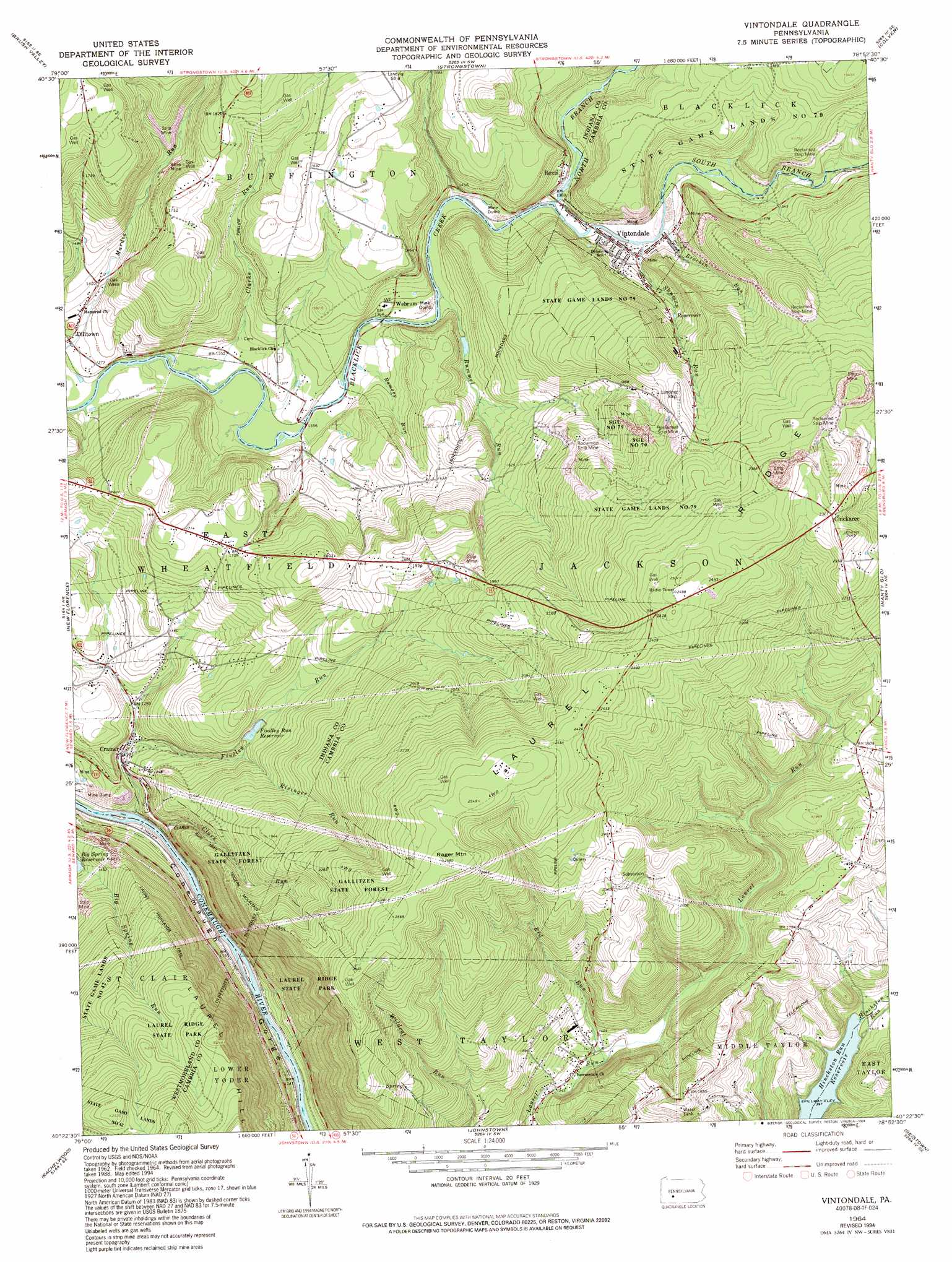
USGS Topo Quad 40078d8 - 1:24,000 scale
| Topo Map Name: | Vintondale |
| USGS Topo Quad ID: | 40078d8 |
| Print Size: | ca. 21 1/4" wide x 27" high |
| Southeast Coordinates: | 40.375° N latitude / 78.875° W longitude |
| Map Center Coordinates: | 40.4375° N latitude / 78.9375° W longitude |
| U.S. State: | PA |
| Filename: | o40078d8.jpg |
| Download Map JPG Image: | Vintondale topo map 1:24,000 scale |
| Map Type: | Topographic |
| Topo Series: | 7.5´ |
| Map Scale: | 1:24,000 |
| Source of Map Images: | United States Geological Survey (USGS) |
| Alternate Map Versions: |
Vintondale PA 1964, updated 1966 Download PDF Buy paper map Vintondale PA 1964, updated 1973 Download PDF Buy paper map Vintondale PA 1964, updated 1994 Download PDF Buy paper map Vintondale PA 1998, updated 1999 Download PDF Buy paper map Vintondale PA 2010 Download PDF Buy paper map Vintondale PA 2013 Download PDF Buy paper map Vintondale PA 2016 Download PDF Buy paper map |
1:24,000 Topo Quads surrounding Vintondale
Ernest |
Clymer |
Commodore |
Barnesboro |
Hastings |
Indiana |
Brush Valley |
Strongstown |
Colver |
Carrolltown |
Bolivar |
New Florence |
Vintondale |
Nanty Glo |
Ebensburg |
Wilpen |
Rachelwood |
Johnstown |
Geistown |
Beaverdale |
Ligonier |
Boswell |
Hooversville |
Windber |
Ogletown |
> Back to 40078a1 at 1:100,000 scale
> Back to 40078a1 at 1:250,000 scale
> Back to U.S. Topo Maps home
Vintondale topo map: Gazetteer
Vintondale: Areas
Charles F Lewis Natural Area elevation 683m 2240′Vintondale: Dams
Buffington Dam elevation 428m 1404′Findley Run Dam elevation 459m 1505′
Laurel Run Dam elevation 426m 1397′
Vintondale: Forests
State Forest Lands elevation 754m 2473′Vintondale: Parks
Charles F Lewis Natural Area elevation 556m 1824′State Game Lands Number 42 elevation 620m 2034′
State Game Lands Number 79 elevation 521m 1709′
Vintondale: Populated Places
Chickaree elevation 724m 2375′Cramer elevation 371m 1217′
Rexis elevation 425m 1394′
Vintondale elevation 429m 1407′
Wehrum elevation 414m 1358′
Vintondale: Reservoirs
Findley Run Reservoir elevation 467m 1532′Laurel Run Reservoir elevation 434m 1423′
Vintondale: Ridges
Laurel Ridge elevation 777m 2549′Vintondale: Streams
Bracken Run elevation 431m 1414′Clark Run elevation 345m 1131′
Clarke Run elevation 408m 1338′
Findley Run elevation 334m 1095′
North Branch Blacklick Creek elevation 420m 1377′
Ramsey Run elevation 412m 1351′
Red Run elevation 420m 1377′
Risinger Run elevation 447m 1466′
Rummel Run elevation 414m 1358′
Shuman Run elevation 434m 1423′
South Branch Blacklick Creek elevation 420m 1377′
Vintondale: Summits
Rager Mountain elevation 786m 2578′Vintondale: Trails
Clark Run Trail elevation 453m 1486′Laurel Highlands Trail elevation 649m 2129′
Roger Mountain Trail elevation 641m 2103′
Vintondale: Valleys
Conemaugh Gorge elevation 330m 1082′Vintondale digital topo map on disk
Buy this Vintondale topo map showing relief, roads, GPS coordinates and other geographical features, as a high-resolution digital map file on DVD:
 map DVD")