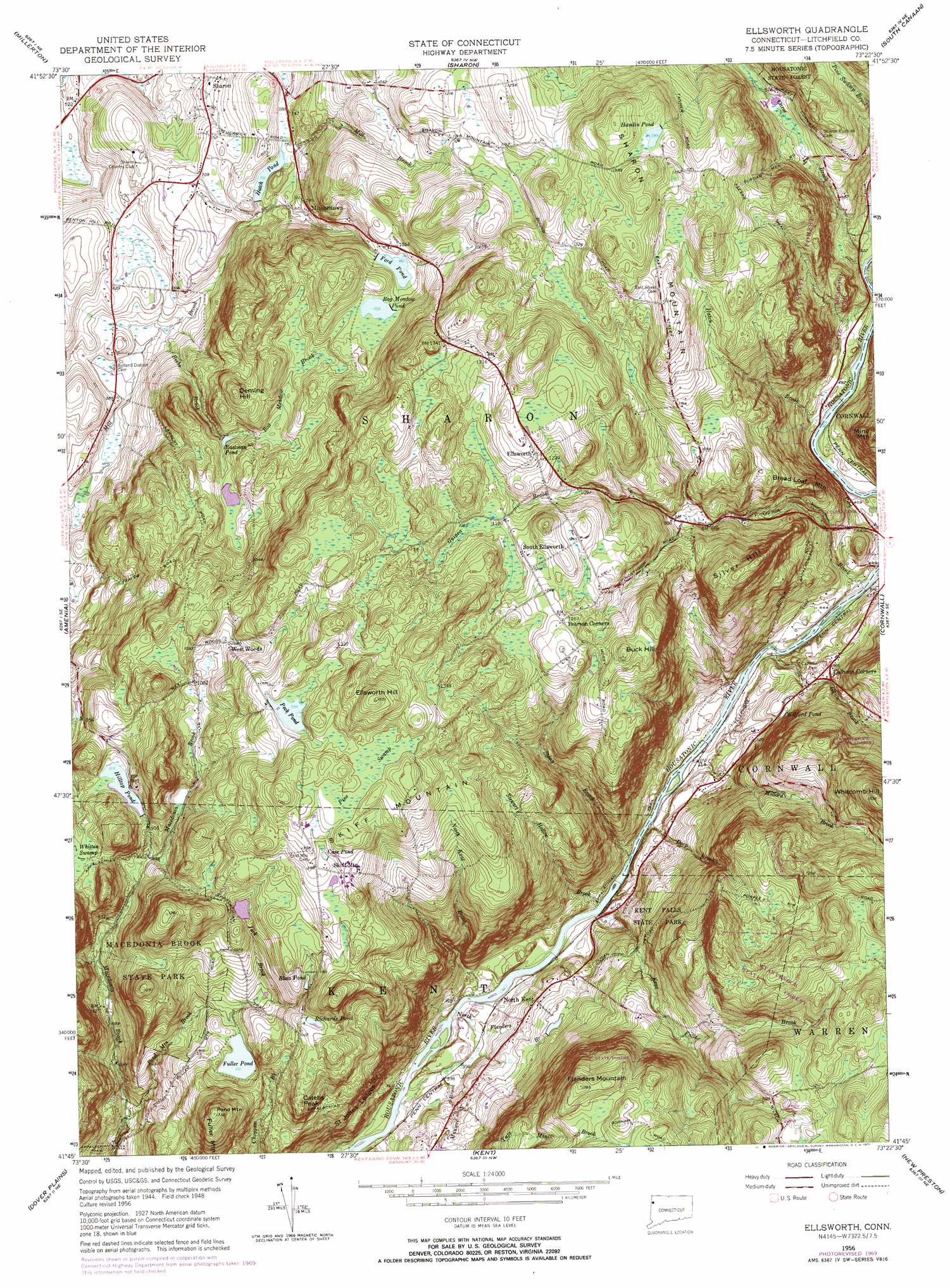
Ellsworth Topo Map Connecticut
To zoom in, hover over the map of Ellsworth
USGS Topo Quad 41073g4 - 1:24,000 scale
| Topo Map Name: | Ellsworth |
| USGS Topo Quad ID: | 41073g4 |
| Print Size: | ca. 21 1/4" wide x 27" high |
| Southeast Coordinates: | 41.75° N latitude / 73.375° W longitude |
| Map Center Coordinates: | 41.8125° N latitude / 73.4375° W longitude |
| U.S. State: | CT |
| Filename: | o41073g4.jpg |
| Download Map JPG Image: | Ellsworth topo map 1:24,000 scale |
| Map Type: | Topographic |
| Topo Series: | 7.5´ |
| Map Scale: | 1:24,000 |
| Source of Map Images: | United States Geological Survey (USGS) |
| Alternate Map Versions: |
Ellsworth CT 1956, updated 1958 Download PDF Buy paper map Ellsworth CT 1956, updated 1966 Download PDF Buy paper map Ellsworth CT 1956, updated 1971 Download PDF Buy paper map Ellsworth CT 1956, updated 1971 Download PDF Buy paper map Ellsworth CT 2012 Download PDF Buy paper map Ellsworth CT 2015 Download PDF Buy paper map |
1:24,000 Topo Quads surrounding Ellsworth
Ancram |
Copake |
Ashley Falls |
||
Pine Plains |
Millerton |
Sharon |
South Canaan |
Norfolk |
Millbrook |
Amenia |
Ellsworth |
Cornwall |
West Torrington |
Verbank |
Dover Plains |
Kent |
New Preston |
Litchfield |
Poughquag |
Pawling |
New Milford |
Roxbury |
Woodbury |
> Back to 41073e1 at 1:100,000 scale
> Back to 41072a1 at 1:250,000 scale
> Back to U.S. Topo Maps home
Ellsworth topo map: Gazetteer
Ellsworth: Benches
Saint Johns Ledges elevation 200m 656′Ellsworth: Dams
Ford Pond Dam elevation 299m 980′Hatch Pond Dam elevation 223m 731′
Hilltop Pond Dam elevation 297m 974′
Jordan Pond Dam elevation 331m 1085′
Peck Pond Dam elevation 385m 1263′
Roger Lewis Pond Dam elevation 281m 921′
Ellsworth: Forests
Wyantenock State Forest elevation 413m 1354′Ellsworth: Lakes
Fuller Pond elevation 276m 905′Wilford Pond elevation 164m 538′
Ellsworth: Parks
Housatonic Meadows State Park elevation 158m 518′Kent Falls State Park elevation 242m 793′
Macedonia Brook State Park elevation 325m 1066′
Pond Mountain Natural Area elevation 406m 1332′
Ellsworth: Populated Places
Calhoun Corners elevation 185m 606′Ellsworth elevation 385m 1263′
Mitcheltown elevation 247m 810′
North Kent elevation 164m 538′
South Ellsworth elevation 373m 1223′
West Woods elevation 329m 1079′
Ellsworth: Reservoirs
Blatz Pond elevation 340m 1115′Bog Meadow Pond elevation 309m 1013′
Case Pond elevation 390m 1279′
Eastman Pond elevation 261m 856′
Ford Pond elevation 299m 980′
Hamlin Pond elevation 416m 1364′
Hatch Pond elevation 223m 731′
Hilltop Pond elevation 297m 974′
Jordan Pond elevation 331m 1085′
Oak Ledge Pond elevation 278m 912′
Peck Pond elevation 385m 1263′
Richards Pond elevation 344m 1128′
Roger Lewis Pond elevation 281m 921′
Ellsworth: Streams
Beebe Brook elevation 170m 557′Bog Meadow Brook elevation 276m 905′
Bonney Brook elevation 128m 419′
Deep Brook elevation 122m 400′
Guinea Brook elevation 127m 416′
Gunn Brook elevation 124m 406′
Hatch Brook elevation 136m 446′
Jack Brook elevation 284m 931′
Kent Falls Brook elevation 117m 383′
Mauwee Brook elevation 112m 367′
Millard Brook elevation 121m 396′
North Flanders Brook elevation 112m 367′
North Kent Brook elevation 116m 380′
Pond Mountain Brook elevation 174m 570′
Stewart Hollow Brook elevation 120m 393′
Stony Brook elevation 121m 396′
Yuza Mini Brook elevation 148m 485′
Ellsworth: Summits
Bread Loaf Mountain elevation 313m 1026′Buck Hill elevation 404m 1325′
Calebs Peak elevation 345m 1131′
Deming Hill elevation 338m 1108′
Ellsworth Hill elevation 473m 1551′
Flanders Mountain elevation 422m 1384′
Pond Mountain elevation 406m 1332′
Sharon Mountain elevation 426m 1397′
Silver Hill elevation 386m 1266′
Skiff Mountain elevation 423m 1387′
Whitcomb Hill elevation 459m 1505′
Ellsworth: Swamps
Pine Swamp elevation 410m 1345′Whitten Swamp elevation 311m 1020′
Ellsworth digital topo map on disk
Buy this Ellsworth topo map showing relief, roads, GPS coordinates and other geographical features, as a high-resolution digital map file on DVD:
New York, Vermont, Connecticut & Western Massachusetts
Buy digital topo maps: New York, Vermont, Connecticut & Western Massachusetts