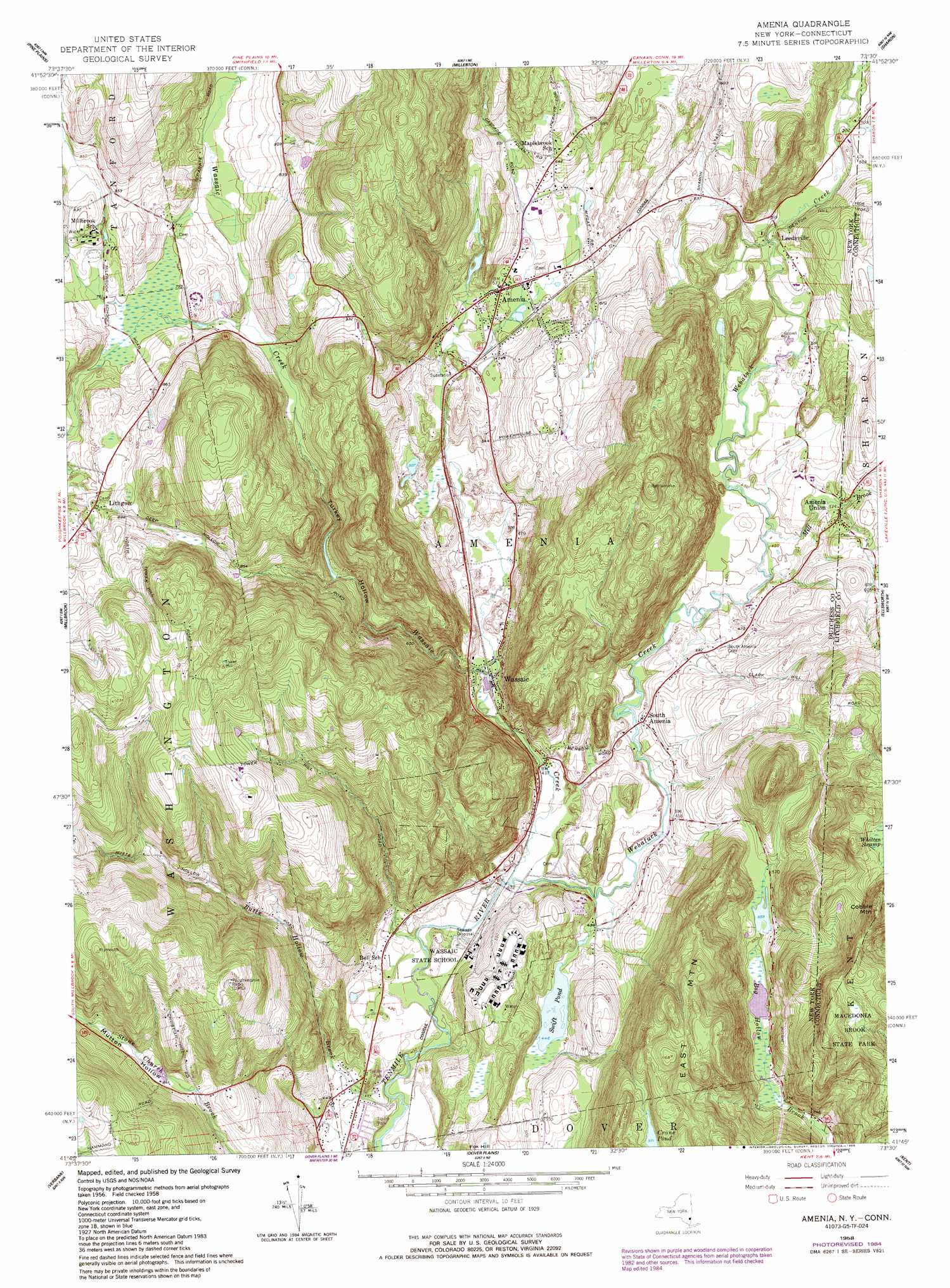
Amenia Topo Map New York
To zoom in, hover over the map of Amenia
USGS Topo Quad 41073g5 - 1:24,000 scale
| Topo Map Name: | Amenia |
| USGS Topo Quad ID: | 41073g5 |
| Print Size: | ca. 21 1/4" wide x 27" high |
| Southeast Coordinates: | 41.75° N latitude / 73.5° W longitude |
| Map Center Coordinates: | 41.8125° N latitude / 73.5625° W longitude |
| U.S. States: | NY, CT |
| Filename: | o41073g5.jpg |
| Download Map JPG Image: | Amenia topo map 1:24,000 scale |
| Map Type: | Topographic |
| Topo Series: | 7.5´ |
| Map Scale: | 1:24,000 |
| Source of Map Images: | United States Geological Survey (USGS) |
| Alternate Map Versions: |
Amenia NY 1958, updated 1959 Download PDF Buy paper map Amenia NY 1958, updated 1967 Download PDF Buy paper map Amenia NY 1958, updated 1977 Download PDF Buy paper map Amenia NY 1958, updated 1984 Download PDF Buy paper map Amenia NY 1958, updated 1988 Download PDF Buy paper map Amenia NY 2010 Download PDF Buy paper map Amenia NY 2013 Download PDF Buy paper map Amenia NY 2016 Download PDF Buy paper map |
1:24,000 Topo Quads surrounding Amenia
Clermont |
Ancram |
Copake |
Ashley Falls |
|
Rock City |
Pine Plains |
Millerton |
Sharon |
South Canaan |
Salt Point |
Millbrook |
Amenia |
Ellsworth |
Cornwall |
Pleasant Valley |
Verbank |
Dover Plains |
Kent |
New Preston |
Hopewell Junction |
Poughquag |
Pawling |
New Milford |
Roxbury |
> Back to 41073e1 at 1:100,000 scale
> Back to 41072a1 at 1:250,000 scale
> Back to U.S. Topo Maps home
Amenia topo map: Gazetteer
Amenia: Lakes
Swift Pond elevation 136m 446′Amenia: Parks
Wassaic State Multiple Use Area elevation 272m 892′Amenia: Populated Places
Amenia elevation 173m 567′Amenia Union elevation 146m 479′
Leedsville elevation 160m 524′
Lithgow elevation 261m 856′
South Amenia elevation 141m 462′
Wassaic elevation 139m 456′
Amenia: Streams
Butts Hollow Brook elevation 119m 390′Indian Lake Creek elevation 149m 488′
Mill Brook elevation 135m 442′
Mill Brook elevation 132m 433′
Stone Church Brook elevation 235m 770′
Wassaic Creek elevation 125m 410′
Webatuck Creek elevation 125m 410′
Amenia: Summits
Cobble Mountain elevation 416m 1364′Amenia: Valleys
Mutton Hollow elevation 246m 807′Turkey Hollow elevation 186m 610′
Amenia digital topo map on disk
Buy this Amenia topo map showing relief, roads, GPS coordinates and other geographical features, as a high-resolution digital map file on DVD:
New York, Vermont, Connecticut & Western Massachusetts
Buy digital topo maps: New York, Vermont, Connecticut & Western Massachusetts