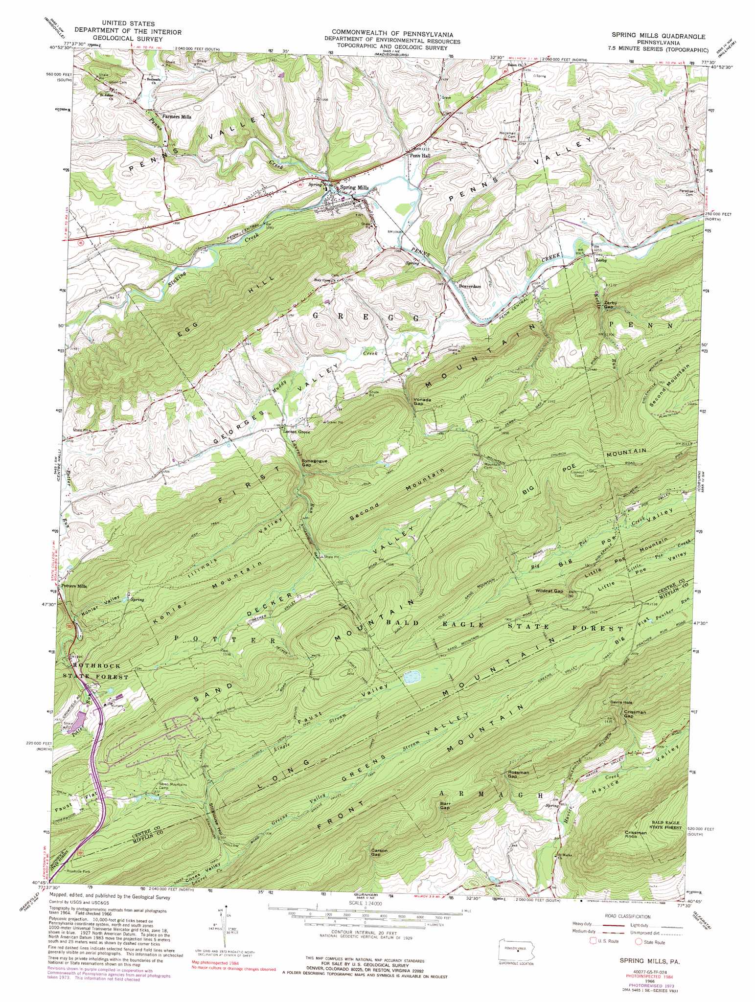
Spring Mills Topo Map Pennsylvania
To zoom in, hover over the map of Spring Mills
USGS Topo Quad 40077g5 - 1:24,000 scale
| Topo Map Name: | Spring Mills |
| USGS Topo Quad ID: | 40077g5 |
| Print Size: | ca. 21 1/4" wide x 27" high |
| Southeast Coordinates: | 40.75° N latitude / 77.5° W longitude |
| Map Center Coordinates: | 40.8125° N latitude / 77.5625° W longitude |
| U.S. State: | PA |
| Filename: | o40077g5.jpg |
| Download Map JPG Image: | Spring Mills topo map 1:24,000 scale |
| Map Type: | Topographic |
| Topo Series: | 7.5´ |
| Map Scale: | 1:24,000 |
| Source of Map Images: | United States Geological Survey (USGS) |
| Alternate Map Versions: |
Spring Mills PA 1966, updated 1968 Download PDF Buy paper map Spring Mills PA 1966, updated 1973 Download PDF Buy paper map Spring Mills PA 1966, updated 1981 Download PDF Buy paper map Spring Mills PA 1966, updated 1988 Download PDF Buy paper map Spring Mills PA 1977, updated 1979 Download PDF Buy paper map Spring Mills PA 1998, updated 1999 Download PDF Buy paper map Spring Mills PA 2010 Download PDF Buy paper map Spring Mills PA 2013 Download PDF Buy paper map Spring Mills PA 2016 Download PDF Buy paper map |
1:24,000 Topo Quads surrounding Spring Mills
Snow Shoe Se |
Howard |
Beech Creek |
Mill Hall |
Loganton |
Bellefonte |
Mingoville |
Madisonburg |
Millheim |
Woodward |
State College |
Centre Hall |
Spring Mills |
Coburn |
Weikert |
Mcalevys Fort |
Barrville |
Burnham |
Alfarata |
Mcclure |
Allensville |
Belleville |
Lewistown |
Mifflintown |
Mexico |
> Back to 40077e1 at 1:100,000 scale
> Back to 40076a1 at 1:250,000 scale
> Back to U.S. Topo Maps home
Spring Mills topo map: Gazetteer
Spring Mills: Airports
Pennfield Farm Airport elevation 359m 1177′Spring Mills: Bends
Devils Hole elevation 359m 1177′Spring Mills: Dams
Penn Nursery Dam elevation 458m 1502′Spring Mills: Flats
Big Flat elevation 634m 2080′Spring Mills: Gaps
Barr Gap elevation 410m 1345′Carson Gap elevation 378m 1240′
Crissman Gap elevation 353m 1158′
Rossman Gap elevation 371m 1217′
Synagogue Gap elevation 398m 1305′
Vonada Gap elevation 428m 1404′
Wildcat Gap elevation 513m 1683′
Zerby Gap elevation 388m 1272′
Spring Mills: Populated Places
Beaverdam elevation 331m 1085′Farmers Mills elevation 353m 1158′
Locust Grove elevation 359m 1177′
Penn Hall elevation 335m 1099′
Spring Mills elevation 337m 1105′
Zerby elevation 326m 1069′
Spring Mills: Ranges
Long Mountain elevation 663m 2175′Spring Mills: Reservoirs
Penn Spring Reservoir elevation 458m 1502′Spring Mills: Springs
Rising Spring elevation 334m 1095′Spring Mills: Streams
Britton Run elevation 423m 1387′Greens Valley Stream elevation 438m 1437′
Kettle Run elevation 320m 1049′
Laurel Run elevation 341m 1118′
Lingle Stream elevation 487m 1597′
Muddy Creek elevation 321m 1053′
Sinking Creek elevation 329m 1079′
Spring Mills: Summits
Big Poe Mountain elevation 651m 2135′Crissman Knob elevation 535m 1755′
Egg Hill elevation 596m 1955′
Front Mountain elevation 604m 1981′
Kohler Mountain elevation 546m 1791′
Sand Mountain elevation 624m 2047′
Spring Mills: Trails
Decker Path elevation 558m 1830′Greens Valley Trail elevation 530m 1738′
Ground Oak Trail elevation 584m 1916′
Indian Trail elevation 482m 1581′
Lingle Trail elevation 550m 1804′
Ripka Trail elevation 540m 1771′
Summit Trail elevation 567m 1860′
Wolf Trail elevation 566m 1856′
Spring Mills: Valleys
Decker Valley elevation 435m 1427′Faust Valley elevation 489m 1604′
Georges Valley elevation 322m 1056′
Greens Valley elevation 468m 1535′
Havice Valley elevation 253m 830′
Illinois Valley elevation 392m 1286′
Kohler Valley elevation 411m 1348′
Stillhouse Hollow elevation 458m 1502′
Triester Valley elevation 455m 1492′
Spring Mills digital topo map on disk
Buy this Spring Mills topo map showing relief, roads, GPS coordinates and other geographical features, as a high-resolution digital map file on DVD:
Atlantic Coast (NY, NJ, PA, DE, MD, VA, NC)
Buy digital topo maps: Atlantic Coast (NY, NJ, PA, DE, MD, VA, NC)
 map DVD")