Mantua Topo Map Ohio
To zoom in, hover over the map of Mantua
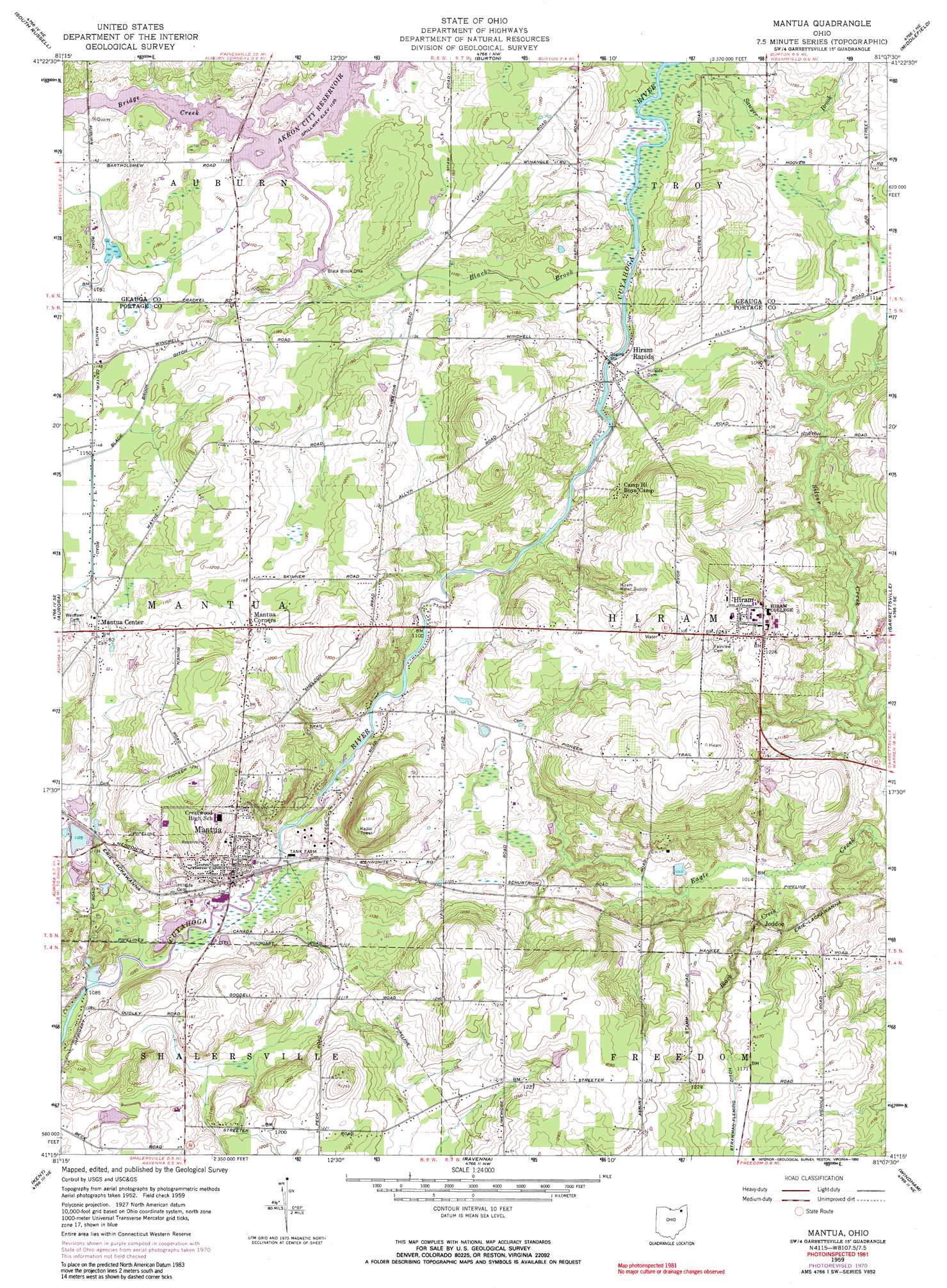
USGS Topo Quad 41081c2 - 1:24,000 scale
| Topo Map Name: | Mantua |
| USGS Topo Quad ID: | 41081c2 |
| Print Size: | ca. 21 1/4" wide x 27" high |
| Southeast Coordinates: | 41.25° N latitude / 81.125° W longitude |
| Map Center Coordinates: | 41.3125° N latitude / 81.1875° W longitude |
| U.S. State: | OH |
| Filename: | o41081c2.jpg |
| Download Map JPG Image: | Mantua topo map 1:24,000 scale |
| Map Type: | Topographic |
| Topo Series: | 7.5´ |
| Map Scale: | 1:24,000 |
| Source of Map Images: | United States Geological Survey (USGS) |
| Alternate Map Versions: |
Mantua OH 1959, updated 1960 Download PDF Buy paper map Mantua OH 1959, updated 1971 Download PDF Buy paper map Mantua OH 1959, updated 1990 Download PDF Buy paper map Mantua OH 1994, updated 1997 Download PDF Buy paper map Mantua OH 2010 Download PDF Buy paper map Mantua OH 2013 Download PDF Buy paper map Mantua OH 2016 Download PDF Buy paper map |
1:24,000 Topo Quads surrounding Mantua
Mayfield Heights |
Chesterland |
Chardon |
East Claridon |
Windsor |
Chagrin Falls |
South Russell |
Burton |
Middlefield |
West Farmington |
Twinsburg |
Aurora |
Mantua |
Garrettsville |
Southington |
Hudson |
Kent |
Ravenna |
Windham |
Newton Falls |
Akron East |
Suffield |
Atwater |
Deerfield |
Lake Milton |
> Back to 41081a1 at 1:100,000 scale
> Back to 41080a1 at 1:250,000 scale
> Back to U.S. Topo Maps home
Mantua topo map: Gazetteer
Mantua: Airports
Far View Airport elevation 396m 1299′Salt Box Airport elevation 379m 1243′
Mantua: Canals
Black Brook Ditch elevation 347m 1138′Strawman-Fleming Ditch elevation 353m 1158′
Mantua: Dams
Black Brook Dike elevation 342m 1122′Mantua: Parks
Charles A Henry Athletic Field elevation 367m 1204′Charles Tummonds State Nature Preserve elevation 328m 1076′
Mantua Center Historic District elevation 356m 1167′
Marsh Wetlands State Nature Preserve elevation 327m 1072′
Mantua: Populated Places
Blackbrook Valley Estates elevation 354m 1161′Hiram elevation 382m 1253′
Hiram Rapids elevation 336m 1102′
Jeddoe elevation 326m 1069′
Mantua elevation 350m 1148′
Mantua Center elevation 356m 1167′
Mantua Corners elevation 365m 1197′
Mantua: Post Offices
Hiram Post Office elevation 384m 1259′Mantua Post Office elevation 347m 1138′
Mantua: Streams
Black Brook elevation 332m 1089′Black Creek elevation 308m 1010′
Mantua: Summits
Derthick Hill elevation 409m 1341′Mantua: Swamps
Mantua Swamp elevation 344m 1128′Mantua digital topo map on disk
Buy this Mantua topo map showing relief, roads, GPS coordinates and other geographical features, as a high-resolution digital map file on DVD:
 map DVD")