Mapleton Topo Map Idaho
To zoom in, hover over the map of Mapleton
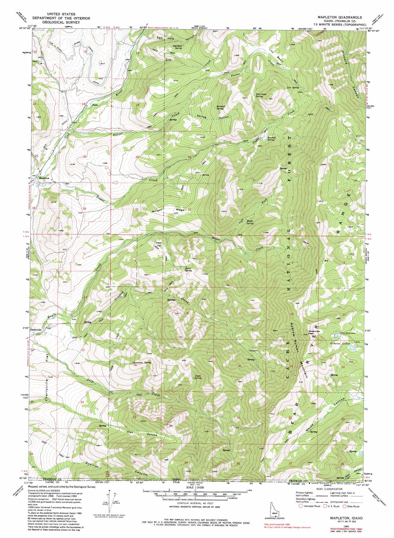
USGS Topo Quad 42111a6 - 1:24,000 scale
| Topo Map Name: | Mapleton |
| USGS Topo Quad ID: | 42111a6 |
| Print Size: | ca. 21 1/4" wide x 27" high |
| Southeast Coordinates: | 42° N latitude / 111.625° W longitude |
| Map Center Coordinates: | 42.0625° N latitude / 111.6875° W longitude |
| U.S. State: | ID |
| Filename: | o42111a6.jpg |
| Download Map JPG Image: | Mapleton topo map 1:24,000 scale |
| Map Type: | Topographic |
| Topo Series: | 7.5´ |
| Map Scale: | 1:24,000 |
| Source of Map Images: | United States Geological Survey (USGS) |
| Alternate Map Versions: |
Mapleton ID 1969, updated 1973 Download PDF Buy paper map Mapleton ID 1969, updated 1981 Download PDF Buy paper map Mapleton ID 1969, updated 1985 Download PDF Buy paper map Mapleton ID 2005, updated 2007 Download PDF Buy paper map Mapleton ID 2011 Download PDF Buy paper map Mapleton ID 2013 Download PDF Buy paper map |
| FStopo: | US Forest Service topo Mapleton is available: Download FStopo PDF Download FStopo TIF |
1:24,000 Topo Quads surrounding Mapleton
Swan Lake |
Treasureton |
Oneida Narrows Reservoir |
Midnight Mountain |
Ovid |
Banida |
Riverdale |
Mink Creek |
Paris Peak |
Paris |
Weston |
Franklin |
Mapleton |
Egan Basin |
Saint Charles |
Trenton |
Richmond |
Naomi Peak |
Tony Grove Creek |
Garden City |
Newton |
Smithfield |
Mount Elmer |
Temple Peak |
Meadowville |
> Back to 42111a1 at 1:100,000 scale
> Back to 42110a1 at 1:250,000 scale
> Back to U.S. Topo Maps home
Mapleton topo map: Gazetteer
Mapleton: Basins
Litz Basin elevation 1978m 6489′Mapleton: Canals
Cub River Worm Creek Canal elevation 1595m 5232′Mapleton: Flats
Cherryville Flat elevation 1668m 5472′Indian Flat elevation 1872m 6141′
Mapleton: Lakes
Gibson Lakes elevation 2581m 8467′Mapleton: Populated Places
Cherryville elevation 1509m 4950′Mapleton elevation 1431m 4694′
Mapleton: Ridges
Morgan Ridge elevation 1914m 6279′Mapleton: Springs
Aspen Spring elevation 2267m 7437′Baker Spring elevation 2057m 6748′
Burbank Spring elevation 1932m 6338′
Chatterton Spring elevation 2091m 6860′
Litz Spring elevation 2085m 6840′
Maple Spring elevation 2000m 6561′
Paul Jones Spring elevation 2181m 7155′
Sawmill Spring elevation 1972m 6469′
Self Help Spring elevation 1783m 5849′
Mapleton: Streams
Carter Creek elevation 2748m 9015′Crooked Creek elevation 1533m 5029′
Flat Canyon elevation 1893m 6210′
Foster Creek elevation 1460m 4790′
Left Fork Maple Creek elevation 1909m 6263′
Litz Creek elevation 1530m 5019′
Sugar Creek elevation 1425m 4675′
Mapleton: Summits
Andrew Nyman Mountain elevation 2876m 9435′Wilderness Peak elevation 2876m 9435′
Mapleton: Valleys
Oxkiller Canyon elevation 1815m 5954′Self Help Hollow elevation 1553m 5095′
South Canyon elevation 1694m 5557′
Spring Flat Canyon elevation 1829m 6000′
Spring Hollow elevation 1762m 5780′
Mapleton digital topo map on disk
Buy this Mapleton topo map showing relief, roads, GPS coordinates and other geographical features, as a high-resolution digital map file on DVD: