Soda Springs Topo Map Idaho
To zoom in, hover over the map of Soda Springs
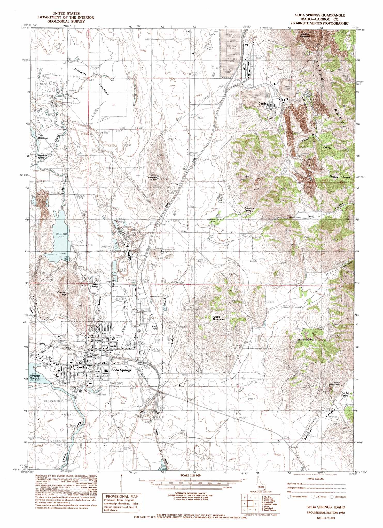
USGS Topo Quad 42111f5 - 1:24,000 scale
| Topo Map Name: | Soda Springs |
| USGS Topo Quad ID: | 42111f5 |
| Print Size: | ca. 21 1/4" wide x 27" high |
| Southeast Coordinates: | 42.625° N latitude / 111.5° W longitude |
| Map Center Coordinates: | 42.6875° N latitude / 111.5625° W longitude |
| U.S. State: | ID |
| Filename: | o42111f5.jpg |
| Download Map JPG Image: | Soda Springs topo map 1:24,000 scale |
| Map Type: | Topographic |
| Topo Series: | 7.5´ |
| Map Scale: | 1:24,000 |
| Source of Map Images: | United States Geological Survey (USGS) |
| Alternate Map Versions: |
Soda Springs ID 1982, updated 1982 Download PDF Buy paper map Soda Springs ID 2010 Download PDF Buy paper map Soda Springs ID 2013 Download PDF Buy paper map |
1:24,000 Topo Quads surrounding Soda Springs
Grizzly Creek |
Reservoir Mountain |
Henry |
Wayan West |
Wayan East |
Hatch |
The Dip |
China Hat |
Lower Valley |
Upper Valley |
Talmage |
Alexander |
Soda Springs |
Johnson Creek |
Dry Valley |
Grace Power Plant |
Grace |
Soda Peak |
Fossil Canyon |
Harrington Peak |
Thatcher Hill |
Thatcher |
North Canyon |
Nounan |
Georgetown |
> Back to 42111e1 at 1:100,000 scale
> Back to 42110a1 at 1:250,000 scale
> Back to U.S. Topo Maps home
Soda Springs topo map: Gazetteer
Soda Springs: Airports
Allen H Tigert Airport elevation 1778m 5833′Soda Springs: Dams
Beker Tailings Number Three Dam elevation 1874m 6148′Conda Site Tailings Dam elevation 1885m 6184′
Soda Creek Dam elevation 1814m 5951′
Soda Springs: Flats
Fivemile Meadows elevation 1824m 5984′Soda Springs: Lakes
The Reservoir elevation 1824m 5984′Soda Springs: Mines
Conda Mine elevation 1910m 6266′Soda Springs: Parks
Kelly Park elevation 1790m 5872′Soda Springs: Populated Places
Conda elevation 1888m 6194′Soda Springs elevation 1760m 5774′
Soda Springs: Springs
Formation Spring elevation 1879m 6164′Hooper Spring elevation 1788m 5866′
Mammath Spring elevation 1824m 5984′
Sulphur Spring elevation 1862m 6108′
Soda Springs: Streams
Big Spring Creek elevation 1745m 5725′Little Spring Creek elevation 1750m 5741′
Soda Creek elevation 1744m 5721′
Soda Springs: Summits
Chester Hill elevation 1949m 6394′Rabbit Mountain elevation 2027m 6650′
Threemile Knoll elevation 1968m 6456′
Soda Springs: Valleys
Jouglard Canyon elevation 1999m 6558′Middle Sulphur Canyon elevation 1858m 6095′
North Sulphur Canyon elevation 1858m 6095′
Shield Canyon elevation 1911m 6269′
South Sulphur Canyon elevation 1858m 6095′
Trail Canyon elevation 1882m 6174′
Wood Canyon elevation 1906m 6253′
Soda Springs digital topo map on disk
Buy this Soda Springs topo map showing relief, roads, GPS coordinates and other geographical features, as a high-resolution digital map file on DVD: