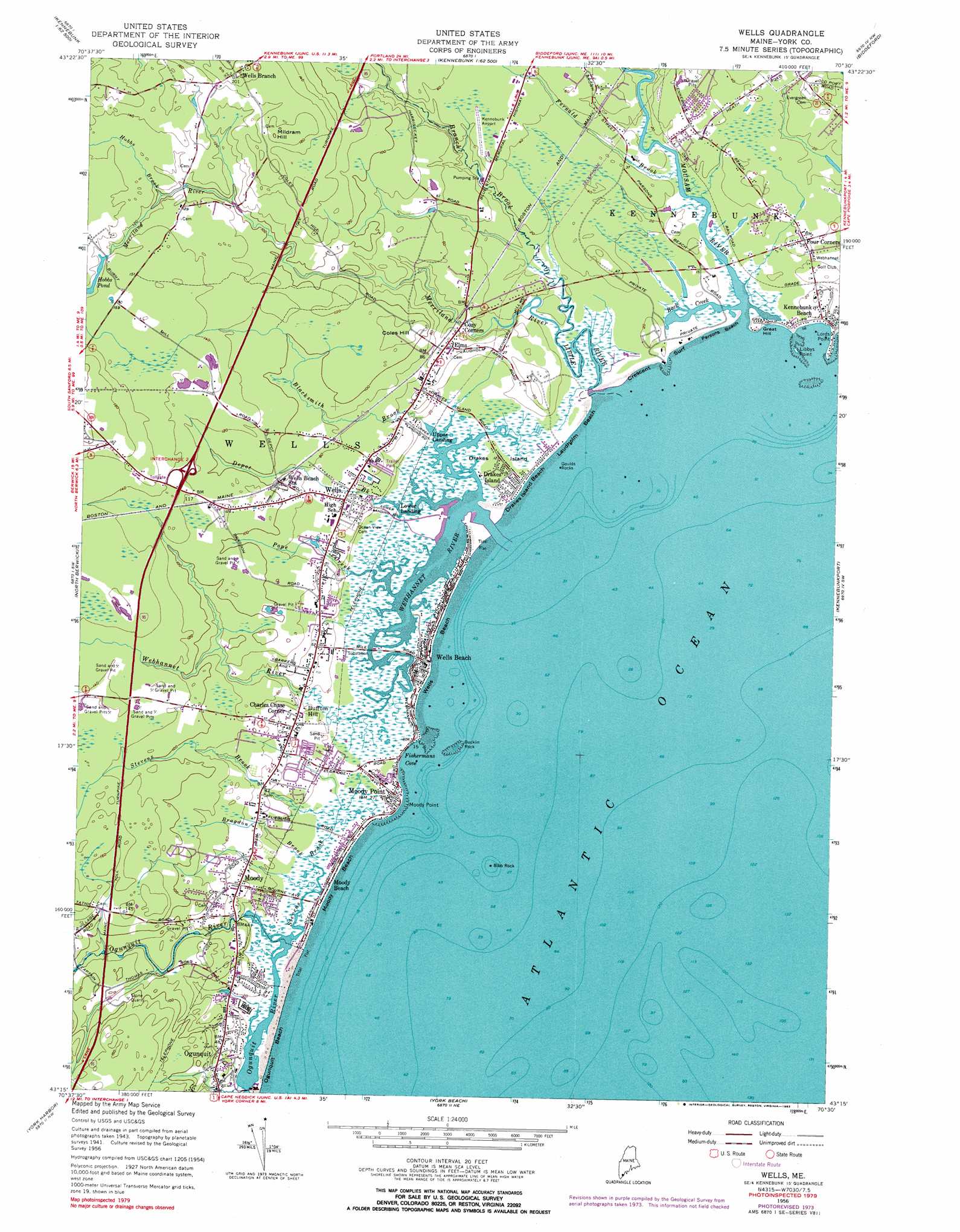
Wells Topo Map Maine
To zoom in, hover over the map of Wells
USGS Topo Quad 43070c5 - 1:24,000 scale
| Topo Map Name: | Wells |
| USGS Topo Quad ID: | 43070c5 |
| Print Size: | ca. 21 1/4" wide x 27" high |
| Southeast Coordinates: | 43.25° N latitude / 70.5° W longitude |
| Map Center Coordinates: | 43.3125° N latitude / 70.5625° W longitude |
| U.S. State: | ME |
| Filename: | o43070c5.jpg |
| Download Map JPG Image: | Wells topo map 1:24,000 scale |
| Map Type: | Topographic |
| Topo Series: | 7.5´ |
| Map Scale: | 1:24,000 |
| Source of Map Images: | United States Geological Survey (USGS) |
| Alternate Map Versions: |
Wells ME 1944 Download PDF Buy paper map Wells ME 1956, updated 1958 Download PDF Buy paper map Wells ME 1956, updated 1967 Download PDF Buy paper map Wells ME 1956, updated 1974 Download PDF Buy paper map Wells ME 1956, updated 1983 Download PDF Buy paper map Wells ME 1956, updated 1983 Download PDF Buy paper map Wells ME 1977, updated 1979 Download PDF Buy paper map Wells ME 2011 Download PDF Buy paper map Wells ME 2014 Download PDF Buy paper map |
1:24,000 Topo Quads surrounding Wells
Mousam Lake |
Waterboro |
Bar Mills |
Old Orchard Beach |
Prouts Neck |
Sanford |
Alfred |
Kennebunk |
Biddeford |
Biddeford Pool |
Somersworth |
North Berwick |
Wells |
Kennebunkport |
|
Dover East |
York Harbor |
York Beach |
||
Portsmouth |
Kittery |
> Back to 43070a1 at 1:100,000 scale
> Back to 43070a1 at 1:250,000 scale
> Back to U.S. Topo Maps home
Wells topo map: Gazetteer
Wells: Airports
Kennebunk Airport elevation 13m 42′Wells: Bars
Bibb Rock elevation 0m 0′Bucklin Rock elevation 1m 3′
Goulds Rocks elevation 0m 0′
Wells: Bays
Back Creek elevation 1m 3′Fishermans Cove elevation 2m 6′
Wells: Beaches
Crescent Surf elevation 0m 0′Drakes Island Beach elevation 0m 0′
Footbridge Beach elevation 0m 0′
Laudholm Beach elevation 9m 29′
Moody Beach elevation 0m 0′
Ogunquit Beach elevation 3m 9′
Parsons Beach elevation 2m 6′
Wells Beach elevation 1m 3′
Wells: Capes
Libbys Point elevation 1m 3′Lords Point elevation 0m 0′
Moody Point elevation 4m 13′
Wells: Crossings
Interchange 2 elevation 38m 124′Wells: Dams
Hobbs Pond Dam elevation 37m 121′Wells: Harbors
Wells Harbor elevation 0m 0′Wells: Islands
Drakes Island elevation 2m 6′Wells: Parks
Rachel Carson National Wildlife Refuge elevation 6m 19′The Wells National Estuarine Research Reserve elevation 16m 52′
Wells: Populated Places
Buffum Hill elevation 9m 29′Charles Chase Corner elevation 14m 45′
Cozy Corners elevation 7m 22′
Drakes Island elevation 2m 6′
Elms elevation 15m 49′
Four Corners elevation 6m 19′
Kennebunk Beach elevation 5m 16′
Lower Landing elevation 2m 6′
Moody elevation 14m 45′
Moody Beach elevation 0m 0′
Moody Point elevation 7m 22′
Upper Landing elevation 0m 0′
Wells elevation 20m 65′
Wells Beach elevation 0m 0′
Wells Beach Station elevation 30m 98′
Wells Branch elevation 60m 196′
Wells: Reservoirs
Hobbs Pond elevation 38m 124′Merriland River Reservoir elevation 43m 141′
Wells: Streams
Blacksmith Brook elevation 0m 0′Bragdon Brook elevation 2m 6′
Branch Brook elevation 0m 0′
Depot Brook elevation 0m 0′
Fernald Brook elevation 0m 0′
Hobbs Brook elevation 28m 91′
Little River elevation 0m 0′
Merriland River elevation 0m 0′
Mousam River elevation 0m 0′
Pope Creek elevation 0m 0′
Stevens Brook elevation 0m 0′
Webhannet River elevation 0m 0′
Wells: Summits
Coles Hill elevation 38m 124′Great Hill elevation 12m 39′
Mildram Hill elevation 60m 196′
Wells: Swamps
Webhannet River Marsh elevation 1m 3′Wells digital topo map on disk
Buy this Wells topo map showing relief, roads, GPS coordinates and other geographical features, as a high-resolution digital map file on DVD:
Maine, New Hampshire, Rhode Island & Eastern Massachusetts
Buy digital topo maps: Maine, New Hampshire, Rhode Island & Eastern Massachusetts