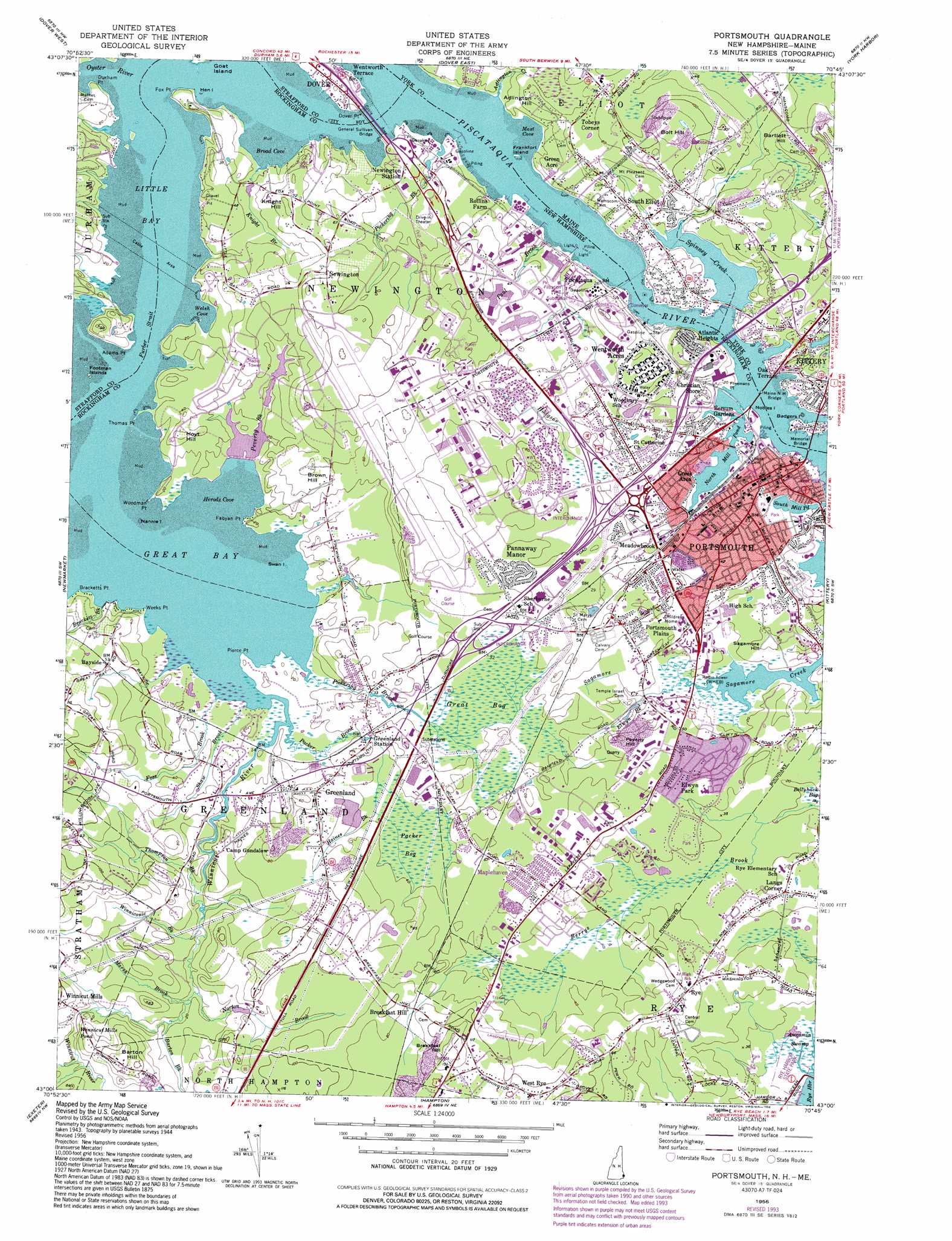
Portsmouth Topo Map New Hampshire
To zoom in, hover over the map of Portsmouth
USGS Topo Quad 43070a7 - 1:24,000 scale
| Topo Map Name: | Portsmouth |
| USGS Topo Quad ID: | 43070a7 |
| Print Size: | ca. 21 1/4" wide x 27" high |
| Southeast Coordinates: | 43° N latitude / 70.75° W longitude |
| Map Center Coordinates: | 43.0625° N latitude / 70.8125° W longitude |
| U.S. States: | NH, ME |
| Filename: | o43070a7.jpg |
| Download Map JPG Image: | Portsmouth topo map 1:24,000 scale |
| Map Type: | Topographic |
| Topo Series: | 7.5´ |
| Map Scale: | 1:24,000 |
| Source of Map Images: | United States Geological Survey (USGS) |
| Alternate Map Versions: |
Portsmouth NH 1956, updated 1963 Download PDF Buy paper map Portsmouth NH 1956, updated 1981 Download PDF Buy paper map Portsmouth NH 1956, updated 1994 Download PDF Buy paper map Portsmouth NH 1956, updated 1994 Download PDF Buy paper map Portsmouth NH 2012 Download PDF Buy paper map Portsmouth NH 2015 Download PDF Buy paper map |
1:24,000 Topo Quads surrounding Portsmouth
Baxter Lake |
Rochester |
Somersworth |
North Berwick |
Wells |
Barrington |
Dover West |
Dover East |
York Harbor |
York Beach |
Epping |
Newmarket |
Portsmouth |
Kittery |
|
Kingston |
Hampton |
Isles of Shoals |
||
Haverhill |
Newburyport East |
> Back to 43070a1 at 1:100,000 scale
> Back to 43070a1 at 1:250,000 scale
> Back to U.S. Topo Maps home
Portsmouth topo map: Gazetteer
Portsmouth: Airports
Cibor Airport elevation 19m 62′Newington Heliport elevation 12m 39′
Pease International Tradeport Airport elevation 19m 62′
Wharf Heliport elevation 1m 3′
Portsmouth: Bars
Nobles Island elevation 0m 0′Portsmouth: Bays
Broad Cove elevation 0m 0′Curriers Cove elevation 0m 0′
Great Bay elevation 0m 0′
Herods Cove elevation 0m 0′
Little Bay elevation 0m 0′
Mast Cove elevation 0m 0′
Old Harbour elevation 0m 0′
Trickys Cove elevation 0m 0′
Welsh Cove elevation 0m 0′
Portsmouth: Bridges
General Sullivan Bridge elevation 0m 0′Maine New Hampshire Bridge elevation 0m 0′
Maine-New Hampshire Bridge elevation 0m 0′
Memorial Bridge elevation 0m 0′
Portsmouth: Capes
Adams Point elevation 0m 0′Bloody Point elevation 1m 3′
Bracketts Point elevation 0m 0′
Durham Point elevation 10m 32′
Fabyan Point elevation 1m 3′
Fox Point elevation 1m 3′
Freemans Point elevation 2m 6′
Pierce Point elevation 0m 0′
Thomas Point elevation 0m 0′
Weeks Point elevation 0m 0′
Woodman Point elevation 0m 0′
Portsmouth: Channels
Furber Strait elevation 0m 0′Portsmouth: Crossings
Interchange 1 elevation 11m 36′Interchange 1 elevation 18m 59′
Interchange 2 elevation 18m 59′
Interchange 3 elevation 12m 39′
Interchange 3 elevation 18m 59′
Interchange 4 elevation 12m 39′
Interchange 4 elevation 7m 22′
Interchange 5 elevation 11m 36′
Interchange 5 elevation 7m 22′
Interchange 6 elevation 5m 16′
Interchange 7 elevation 8m 26′
Portsmouth: Dams
Peverly Brook Lower Dam elevation 6m 19′Peverly Brook Upper Dam elevation 4m 13′
South Mill Pond Dam elevation 4m 13′
Spinney Creek Causeway Dam elevation 0m 0′
Winnicut River Dam elevation 2m 6′
Portsmouth: Islands
Badgers Island elevation 9m 29′Footman Islands elevation 0m 0′
Frankfort Island elevation 0m 0′
Goat Island elevation 0m 0′
Hen Island elevation 0m 0′
Nannie Island elevation 0m 0′
Swan Island elevation 0m 0′
Portsmouth: Lakes
Clamshell Pond elevation 10m 32′North Mill Pond elevation -1m -4′
Portsmouth: Parks
Adams Point State Wildlife Refuge elevation 13m 42′Albacore Park elevation 0m 0′
Clough Field elevation 6m 19′
Elwyn Park elevation 12m 39′
Haven Park elevation 4m 13′
Haymarket Square elevation 6m 19′
Hilton State Park (historical) elevation 6m 19′
Hislop Park elevation 14m 45′
Leary Field elevation 4m 13′
Liberty Gardens elevation 5m 16′
Market Square elevation 7m 22′
Newington Center Historic District elevation 28m 91′
Newington Town Conservation Area elevation 17m 55′
Newington Town Park elevation 11m 36′
Parade Mall elevation 7m 22′
Portsmouth Plains elevation 19m 62′
Prescott Park elevation 1m 3′
Rye Harbor State Park elevation 2m 6′
South Playground elevation 4m 13′
Strwaberry Banke Historic District elevation 6m 19′
The Woodlands elevation 13m 42′
Portsmouth: Pillars
Carters Rock elevation 12m 39′Portsmouth: Populated Places
Acorn Acres elevation 13m 42′Atlantic Heights elevation 17m 55′
Bayside elevation 18m 59′
Bersum Gardens elevation 1m 3′
Breakfast Hill elevation 20m 65′
Camp Gundalow elevation 15m 49′
Christian Shore elevation 18m 59′
Colonial Pines elevation 16m 52′
Creek Area elevation 10m 32′
Elwyn Park elevation 17m 55′
Green Acre elevation 13m 42′
Greenland elevation 18m 59′
Greenland Station elevation 12m 39′
Hillcrest Estates elevation 10m 32′
Langs Corner elevation 13m 42′
Maplehaven elevation 19m 62′
Meadowbrook elevation 6m 19′
Newington elevation 24m 78′
Newington Station elevation 6m 19′
Oak Terrace elevation 14m 45′
Pannaway Manor elevation 17m 55′
Piscataqua elevation 11m 36′
Portsmouth elevation 6m 19′
Portsmouth Mobile Homes elevation 12m 39′
Portsmouth Plains elevation 11m 36′
Puddle Dock (historical) elevation 6m 19′
Rye elevation 23m 75′
Seacrest Village elevation 22m 72′
South Eliot elevation 10m 32′
South Newington elevation 12m 39′
Tobeys Corner elevation 20m 65′
Wentworth Acres elevation 19m 62′
Wentworth Terrace elevation 2m 6′
West Rye elevation 32m 104′
Winnicut Mills elevation 31m 101′
Portsmouth: Post Offices
Greenland Post Office elevation 9m 29′Portsmouth Post Office elevation 7m 22′
Portsmouth: Reservoirs
Coombs Pond elevation 21m 68′Mill Pond elevation 7m 22′
Peverly Brook Lower Pond elevation 6m 19′
Peverly Brook Upper Pond elevation 4m 13′
South Mill Pond elevation 4m 13′
Spinney Creek elevation 0m 0′
Winnicut Mills Pond elevation 11m 36′
Winnicut River Reservoir elevation 2m 6′
Portsmouth: Streams
Adlington Creek elevation 1m 3′Barton Brook elevation 14m 45′
Brackett Brook elevation 0m 0′
Elwyn Brook elevation 6m 19′
Foss Brook elevation 0m 0′
Haines Brook elevation 11m 36′
Hodgson Brook elevation 1m 3′
Knight Branch elevation 0m 0′
Marsh Brook elevation 4m 13′
Norton Brook elevation 5m 16′
Oyster River elevation 0m 0′
Packer Brook elevation 0m 0′
Paul Brook elevation 6m 19′
Peverly Brook elevation 1m 3′
Pickering Brook elevation 0m 0′
Pickering Brook elevation 2m 6′
Shaw Brook elevation 0m 0′
Spinney Creek elevation 0m 0′
Thompson Brook elevation 3m 9′
Winniconic Brook elevation 4m 13′
Winnicut River elevation 0m 0′
Portsmouth: Summits
Adlington Hill elevation 21m 68′Bartlett Hill elevation 26m 85′
Barton Hill elevation 40m 131′
Bolt Hill elevation 40m 131′
Breakfast Hill elevation 44m 144′
Brown Hill elevation 25m 82′
Hoyt Hill elevation 19m 62′
Knight Hill elevation 24m 78′
Peverly Hill elevation 25m 82′
Sagamore Hill elevation 12m 39′
Portsmouth: Swamps
Awcomin Swamp elevation 1m 3′Bellyhack Bog elevation 8m 26′
Great Bog elevation 9m 29′
Packer Bog elevation 8m 26′
Portsmouth digital topo map on disk
Buy this Portsmouth topo map showing relief, roads, GPS coordinates and other geographical features, as a high-resolution digital map file on DVD:
Maine, New Hampshire, Rhode Island & Eastern Massachusetts
Buy digital topo maps: Maine, New Hampshire, Rhode Island & Eastern Massachusetts