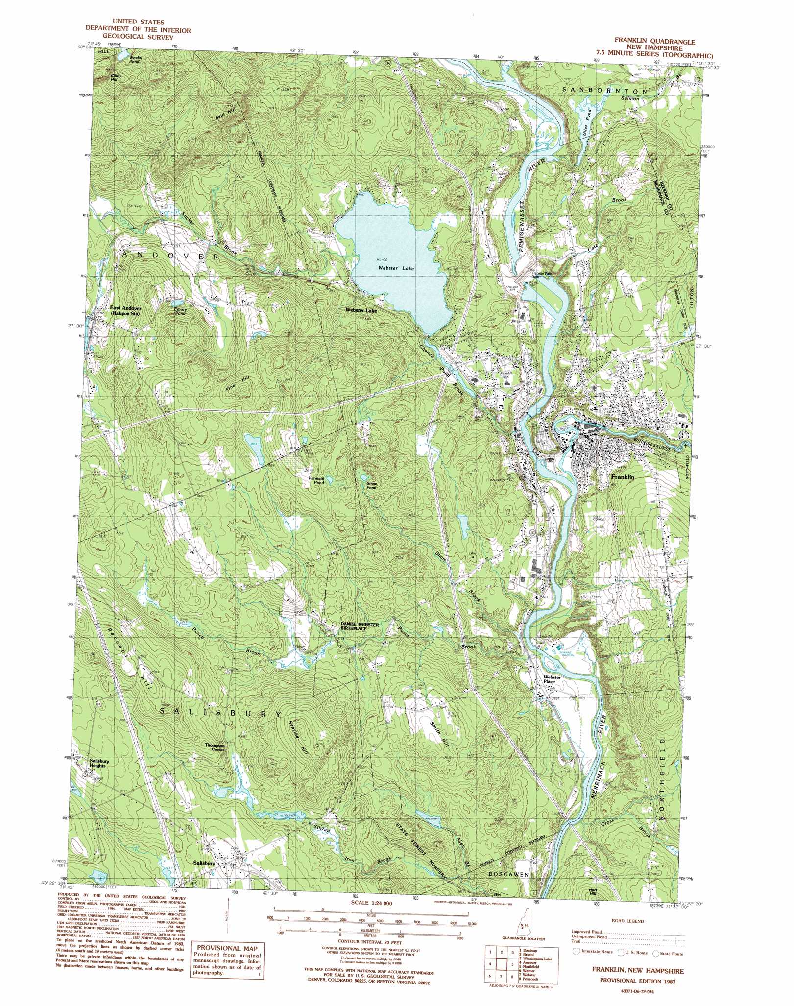
Franklin Topo Map New Hampshire
To zoom in, hover over the map of Franklin
USGS Topo Quad 43071d6 - 1:24,000 scale
| Topo Map Name: | Franklin |
| USGS Topo Quad ID: | 43071d6 |
| Print Size: | ca. 21 1/4" wide x 27" high |
| Southeast Coordinates: | 43.375° N latitude / 71.625° W longitude |
| Map Center Coordinates: | 43.4375° N latitude / 71.6875° W longitude |
| U.S. State: | NH |
| Filename: | o43071d6.jpg |
| Download Map JPG Image: | Franklin topo map 1:24,000 scale |
| Map Type: | Topographic |
| Topo Series: | 7.5´ |
| Map Scale: | 1:24,000 |
| Source of Map Images: | United States Geological Survey (USGS) |
| Alternate Map Versions: |
Franklin NH 1987, updated 1987 Download PDF Buy paper map Franklin NH 2000, updated 2001 Download PDF Buy paper map Franklin NH 2012 Download PDF Buy paper map Franklin NH 2015 Download PDF Buy paper map |
1:24,000 Topo Quads surrounding Franklin
Mount Cardigan |
Newfound Lake |
Ashland |
Holderness |
Center Harbor |
Grafton |
Danbury |
Bristol |
Winnisquam Lake |
Laconia |
New London |
Andover |
Franklin |
Northfield |
Belmont |
Bradford |
Warner |
Webster |
Penacook |
Loudon |
Hillsboro Upper Village |
Henniker |
Hopkinton |
Concord |
Suncook |
> Back to 43071a1 at 1:100,000 scale
> Back to 43070a1 at 1:250,000 scale
> Back to U.S. Topo Maps home
Franklin topo map: Gazetteer
Franklin: Airports
D W Heliport elevation 109m 357′Ward Field elevation 136m 446′
Franklin: Bridges
Daniel Webster Bridge elevation 83m 272′Sulphite Bridge elevation 104m 341′
Franklin: Dams
Eastman Falls Dam elevation 95m 311′Franklin Falls Dam elevation 127m 416′
Franklin Falls Dam elevation 121m 396′
Giles Pond Dam elevation 133m 436′
Highland Lake Dam elevation 201m 659′
New Pond Dam elevation 298m 977′
Sulloway Mills Dam elevation 83m 272′
Webster Lake Dam elevation 124m 406′
Franklin: Lakes
Emory Pond elevation 243m 797′Giles Pond elevation 124m 406′
Shaw Pond elevation 236m 774′
Vermetti Pond elevation 260m 853′
Webster Lake elevation 122m 400′
Weeks Pond elevation 352m 1154′
Franklin: Parks
Franklin Falls Historic District elevation 93m 305′Odell Park elevation 89m 291′
Franklin: Populated Places
East Andover elevation 205m 672′Franklin elevation 93m 305′
Salisbury elevation 249m 816′
Salisbury Heights elevation 272m 892′
Shaw Corner (historical) elevation 179m 587′
Thompson Corner elevation 210m 688′
Webster Lake elevation 130m 426′
Webster Place elevation 90m 295′
West Franklin elevation 129m 423′
Franklin: Post Offices
East Andover Post Office elevation 204m 669′Franklin Post Office elevation 92m 301′
Salisbury Post Office elevation 245m 803′
Franklin: Reservoirs
Giles Pond elevation 133m 436′Highland Lake elevation 201m 659′
New Pond elevation 298m 977′
Pemigewasset River Reservoir elevation 95m 311′
Webster Lake and Chance Pond elevation 124m 406′
Winnepesaukee River Reservoir elevation 83m 272′
Franklin: Streams
Allen Brook elevation 112m 367′Cate Brook elevation 94m 308′
Chance Pond Branch elevation 87m 285′
Cross Brook elevation 79m 259′
Pemigewasset River elevation 81m 265′
Punch Brook elevation 79m 259′
Salmon Brook elevation 97m 318′
Shaw Brook elevation 79m 259′
Sucker Brook elevation 122m 400′
Threshing Mill Brook elevation 128m 419′
Weeks Brook elevation 98m 321′
Winnipesaukee River elevation 84m 275′
Franklin: Summits
Bald Hill elevation 399m 1309′Cilley Hill elevation 423m 1387′
Pine Hill elevation 331m 1085′
Searles Hill elevation 319m 1046′
Smith Hill elevation 238m 780′
Franklin digital topo map on disk
Buy this Franklin topo map showing relief, roads, GPS coordinates and other geographical features, as a high-resolution digital map file on DVD:
Maine, New Hampshire, Rhode Island & Eastern Massachusetts
Buy digital topo maps: Maine, New Hampshire, Rhode Island & Eastern Massachusetts