Claremont North Topo Map New Hampshire
To zoom in, hover over the map of Claremont North
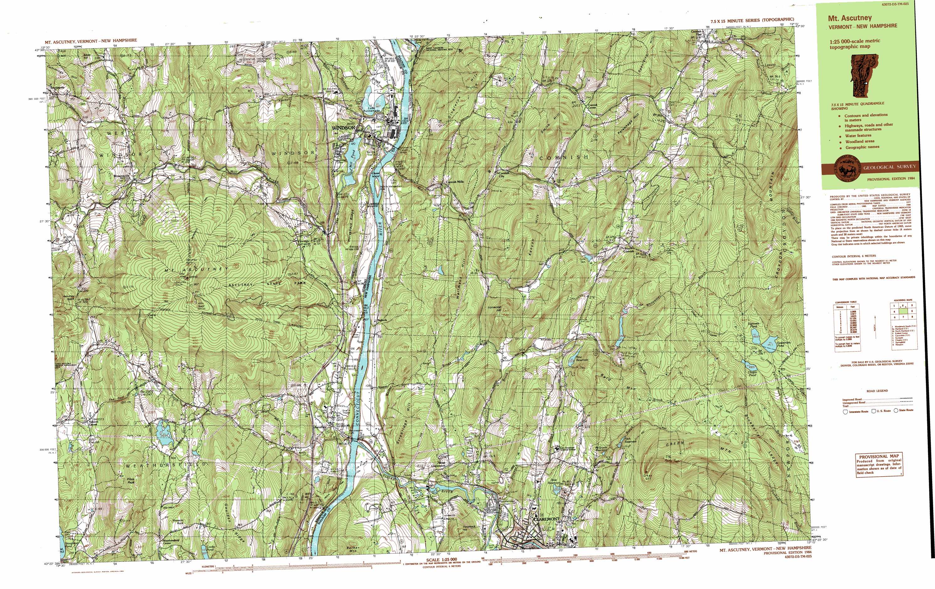
USGS Topo Quad 43072d3 - 1:25,000 scale
| Topo Map Name: | Claremont North |
| USGS Topo Quad ID: | 43072d3 |
| Print Size: | ca. 39" wide x 24" high |
| Southeast Coordinates: | 43.375° N latitude / 72.25° W longitude |
| Map Center Coordinates: | 43.4375° N latitude / 72.375° W longitude |
| U.S. State: | NH |
| Filename: | k43072d3.jpg |
| Download Map JPG Image: | Claremont North topo map 1:25,000 scale |
| Map Type: | Topographic |
| Topo Series: | 7.5´x15´ |
| Map Scale: | 1:25,000 |
| Source of Map Images: | United States Geological Survey (USGS) |
| Alternate Map Versions: |
Mt. Ascutney NH 1984 Download PDF Buy paper map Mt. Ascutney NH 1984, updated 1984 Download PDF Buy paper map |
1:24,000 Topo Quads surrounding Claremont North
Woodstock North |
Quechee |
Hanover |
Canaan |
|
Woodstock South |
Hartland |
North Hartland |
Enfield Center |
|
Cavendish |
Claremont North |
Sunapee Lake North |
||
Chester |
Claremont South |
Sunapee Lakes |
||
Saxtons River |
Alstead |
Washington |
> Back to 43072a1 at 1:100,000 scale
> Back to 43072a1 at 1:250,000 scale
> Back to U.S. Topo Maps home
Claremont North topo map: Gazetteer
Claremont North: Airports
Miller Airport elevation 104m 341′Windsor Armory Heliport elevation 134m 439′
Claremont North: Bridges
Blacksmith Shop Bridge elevation 174m 570′Bowers Covered Bridge elevation 221m 725′
Cornish Bridge elevation 90m 295′
Cornish Bridge elevation 90m 295′
Cornish-Windsor Bridge elevation 90m 295′
Dingleton Hill Bridge elevation 135m 442′
Lottery Bridge elevation 91m 298′
Claremont North: Crossings
Interchange 8 elevation 156m 511′Claremont North: Dams
Blow-Me-Down Pond Dam elevation 160m 524′Coy Dam elevation 109m 357′
Dole Reservoir Dam elevation 207m 679′
Fitch Reservoir Dam elevation 317m 1040′
Howland Dam elevation 235m 770′
Lake Runnemede Dam elevation 96m 314′
Rice Reservoir Dam elevation 250m 820′
Straw Reservoir Dam elevation 223m 731′
Whitewater Brook Dam Number 2 elevation 282m 925′
Windsor Upper Dam elevation 115m 377′
Claremont North: Falls
Crystal Cascade Falls elevation 447m 1466′Gerrys Falls elevation 451m 1479′
Little Cascade Falls elevation 544m 1784′
Claremont North: Forests
Windsor Municipal Forest elevation 127m 416′Claremont North: Gaps
Ascutney Notch elevation 319m 1046′Claremont North: Islands
Chase Island elevation 96m 314′Claremont North: Lakes
Blow-me-down Pond elevation 98m 321′Chapin Pond elevation 485m 1591′
Cooks Pond elevation 338m 1108′
Governors Pond elevation 491m 1610′
Lake Runnenede elevation 98m 321′
Mill Pond elevation 118m 387′
Stoughton Pond elevation 153m 501′
Stoughton Pond elevation 153m 501′
Sumners Pond elevation 493m 1617′
Claremont North: Parks
Ascutney State Park elevation 564m 1850′Chase Island State Wildlife Management Area elevation 93m 305′
Cornish State Wildlife Management Area elevation 149m 488′
Little Ascutney State Wildlife Manage Area elevation 433m 1420′
Saint Gaudens National Historic Site elevation 111m 364′
Saint-Gaudens National Historic Site elevation 100m 328′
Weathersfield Center Historic District elevation 357m 1171′
Wilgus State Park elevation 140m 459′
Windsor Village Historic District elevation 111m 364′
Claremont North: Populated Places
Ascutney elevation 124m 406′Balloch elevation 111m 364′
Brownsville elevation 208m 682′
Claremont elevation 151m 495′
Cornish Center elevation 261m 856′
Cornish City elevation 189m 620′
Cornish Flat elevation 255m 836′
Cornish Mills elevation 135m 442′
Nelsons Corner elevation 210m 688′
Sheddsville elevation 355m 1164′
South Cornish elevation 293m 961′
West Claremont elevation 151m 495′
Windsor elevation 101m 331′
Claremont North: Reservoirs
Blow-Me-Down Pond elevation 160m 524′Dole Reservoir elevation 207m 679′
Fitch Reservoir elevation 308m 1010′
Fitch Reservoir elevation 317m 1040′
Lake Runnemede elevation 96m 314′
McQuade Reservoir elevation 255m 836′
Rice Reservoir elevation 250m 820′
Rice Reservoir elevation 248m 813′
Straw Reservoir elevation 223m 731′
Sugar River Reservoir elevation 109m 357′
Whitewater Reservoir elevation 282m 925′
Claremont North: Ridges
Blueberry Ledge elevation 514m 1686′Goulden Ridge elevation 415m 1361′
Horseback Ridge elevation 190m 623′
Claremont North: Streams
Beaver Brook elevation 204m 669′Blow-me-down Brook elevation 90m 295′
Grandy Brook elevation 162m 531′
Hubbard Brook elevation 93m 305′
Kimball Brook elevation 133m 436′
Leavitt Brook elevation 325m 1066′
Mill Brook elevation 88m 288′
Mill Brook elevation 90m 295′
Mill Brook elevation 89m 291′
Notch Brook elevation 297m 974′
Perry Brook elevation 383m 1256′
Redwater Brook elevation 111m 364′
Stevens Brook elevation 115m 377′
Sugar River elevation 88m 288′
Walker Brook elevation 90m 295′
Whitewater Brook elevation 270m 885′
Claremont North: Summits
Ascutney North elevation 944m 3097′Ascutney South elevation 954m 3129′
Bald Mountain elevation 433m 1420′
Barber Mountain elevation 265m 869′
Cummings Hill elevation 420m 1377′
Dingleton Hill elevation 400m 1312′
Green Mountain elevation 611m 2004′
Ironwood Hill elevation 332m 1089′
Kenyon Hill elevation 395m 1295′
Mount Ascutney elevation 945m 3100′
Parsonage Hill elevation 416m 1364′
Pikes Peak elevation 409m 1341′
Pinnacle Rock elevation 415m 1361′
Silver Hill elevation 371m 1217′
Smith Hill elevation 393m 1289′
Spaulding Hill elevation 438m 1437′
Strobridge Hill elevation 247m 810′
Twistback Hill elevation 264m 866′
Wellmans Hill elevation 340m 1115′
Claremont North: Trails
Futures Trail elevation 387m 1269′Hang Glider Trail elevation 870m 2854′
Slot Trail elevation 865m 2837′
Claremont North: Valleys
The Gulf elevation 209m 685′The Narrows elevation 118m 387′
Claremont North digital topo map on disk
Buy this Claremont North topo map showing relief, roads, GPS coordinates and other geographical features, as a high-resolution digital map file on DVD:
New York, Vermont, Connecticut & Western Massachusetts
Buy digital topo maps: New York, Vermont, Connecticut & Western Massachusetts