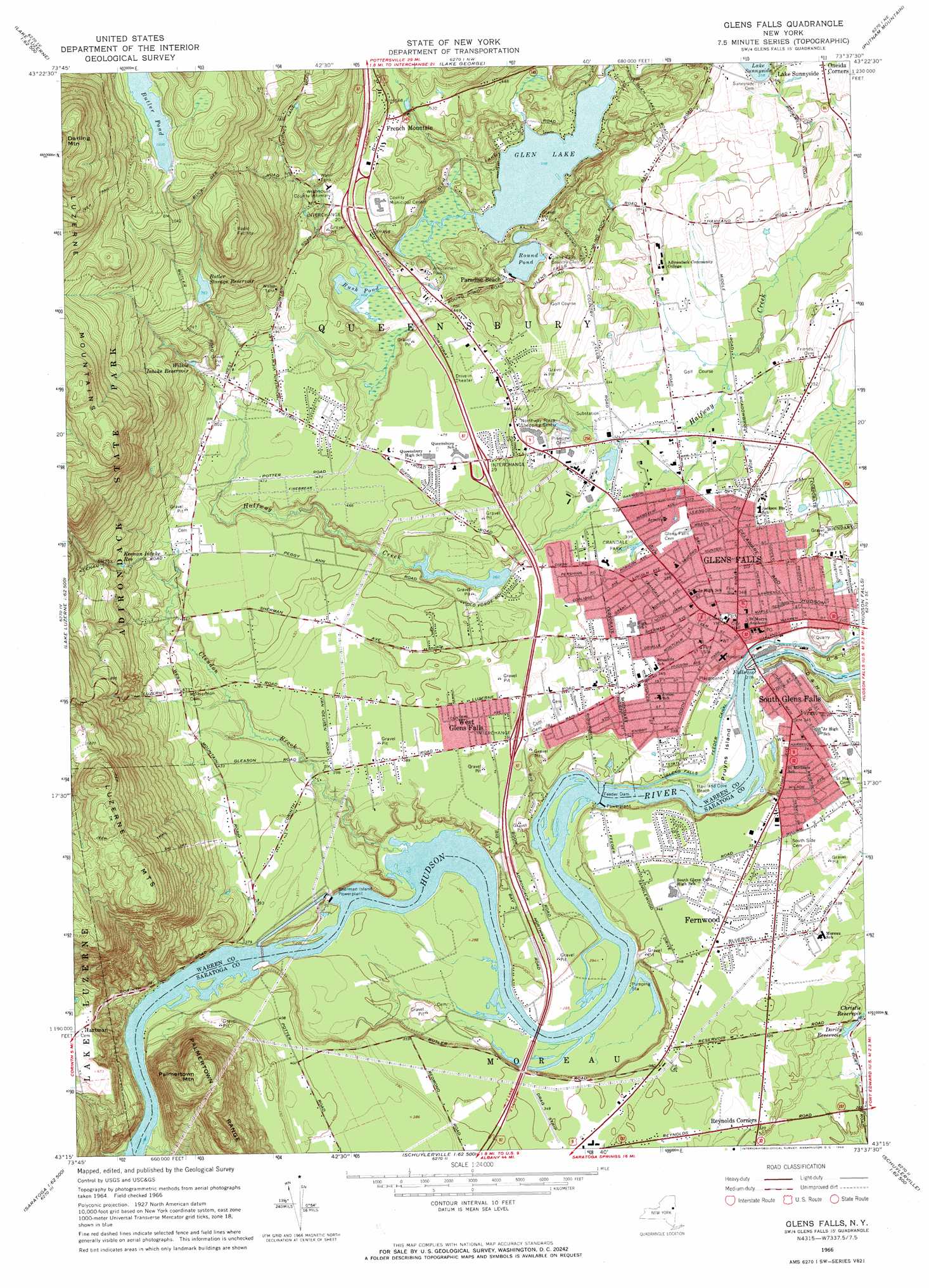
Glens Falls Topo Map New York
To zoom in, hover over the map of Glens Falls
USGS Topo Quad 43073c6 - 1:24,000 scale
| Topo Map Name: | Glens Falls |
| USGS Topo Quad ID: | 43073c6 |
| Print Size: | ca. 21 1/4" wide x 27" high |
| Southeast Coordinates: | 43.25° N latitude / 73.625° W longitude |
| Map Center Coordinates: | 43.3125° N latitude / 73.6875° W longitude |
| U.S. State: | NY |
| Filename: | o43073c6.jpg |
| Download Map JPG Image: | Glens Falls topo map 1:24,000 scale |
| Map Type: | Topographic |
| Topo Series: | 7.5´ |
| Map Scale: | 1:24,000 |
| Source of Map Images: | United States Geological Survey (USGS) |
| Alternate Map Versions: |
Glens Falls NY 1966, updated 1968 Download PDF Buy paper map Glens Falls NY 2010 Download PDF Buy paper map Glens Falls NY 2013 Download PDF Buy paper map Glens Falls NY 2016 Download PDF Buy paper map |
1:24,000 Topo Quads surrounding Glens Falls
Johnsburg |
The Glen |
Bolton Landing |
Shelving Rock |
Whitehall |
Stony Creek |
Warrensburg |
Lake George |
Putnam Mountain |
Fort Ann |
Conklingville |
Lake Luzerne |
Glens Falls |
Hudson Falls |
Hartford |
Porter Corners |
Corinth |
Gansevoort |
Fort Miller |
Cossayuna |
Middle Grove |
Saratoga Springs |
Quaker Springs |
Schuylerville |
Cambridge |
> Back to 43073a1 at 1:100,000 scale
> Back to 43072a1 at 1:250,000 scale
> Back to U.S. Topo Maps home
Glens Falls topo map: Gazetteer
Glens Falls: Beaches
Haviland Cove Beach elevation 79m 259′Glens Falls: Crossings
Interchange 18 elevation 118m 387′Interchange 19 elevation 140m 459′
Interchange 20 elevation 154m 505′
Glens Falls: Islands
Pruyns Island elevation 85m 278′Glens Falls: Lakes
Butler Pond elevation 316m 1036′Glen Lake elevation 121m 396′
Round Pond elevation 122m 400′
Rush Pond elevation 122m 400′
Glens Falls: Parks
Crandall Park elevation 104m 341′Crandall Park elevation 104m 341′
East Playground elevation 101m 331′
Moreau Town Park elevation 102m 334′
Nibco Park elevation 99m 324′
Glens Falls: Populated Places
Bluebird Trailer Park elevation 104m 341′Evergreen Trailer Park elevation 105m 344′
Fernwood elevation 105m 344′
French Mountain elevation 164m 538′
Glens Falls elevation 105m 344′
Gregory Manor elevation 102m 334′
Hartman elevation 203m 666′
Lake Sunnyside elevation 111m 364′
Lamplighter Acres elevation 106m 347′
Paradise Beach elevation 124m 406′
Pine Valley elevation 105m 344′
Pruyn Crest elevation 107m 351′
Reynolds Corners elevation 98m 321′
Shady Pines Trailer Park elevation 105m 344′
South Glens Falls elevation 105m 344′
Spier Pines elevation 106m 347′
Sweets Trailer Park elevation 106m 347′
West Glens Falls elevation 116m 380′
White Birch Estates elevation 103m 337′
Glens Falls: Reservoirs
Butler Storage Reservoir elevation 232m 761′Christie Reservoir elevation 87m 285′
Dority Reservoir elevation 83m 272′
Keenan Intake Reservoir elevation 178m 583′
Wilkie Intake Reservoir elevation 176m 577′
Glens Falls: Streams
Clendon Brook elevation 85m 278′Glens Falls: Summits
Palmertown Mountain elevation 317m 1040′Glens Falls digital topo map on disk
Buy this Glens Falls topo map showing relief, roads, GPS coordinates and other geographical features, as a high-resolution digital map file on DVD:
New York, Vermont, Connecticut & Western Massachusetts
Buy digital topo maps: New York, Vermont, Connecticut & Western Massachusetts