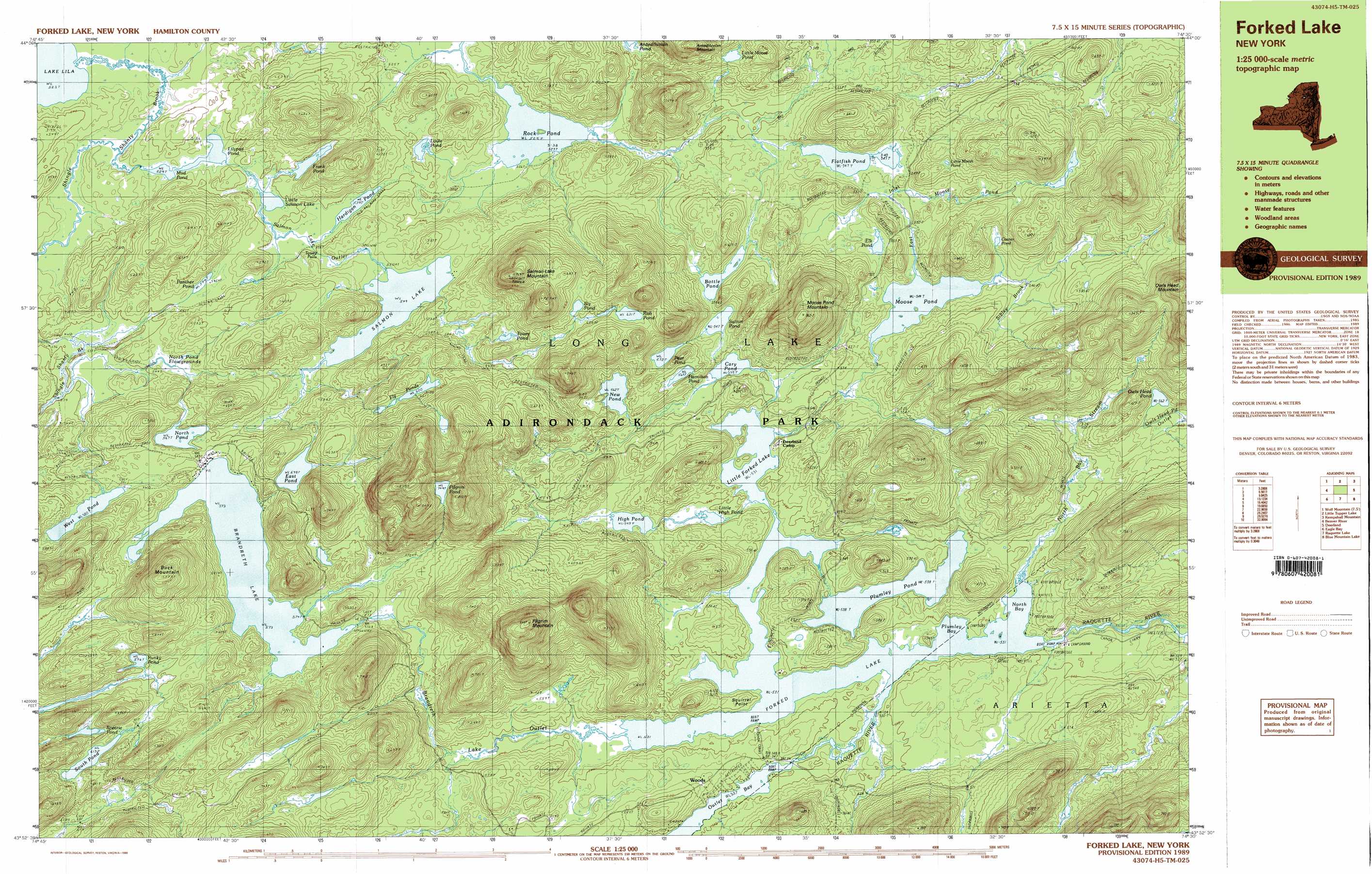
Forked Lake Topo Map New York
To zoom in, hover over the map of Forked Lake
USGS Topo Quad 43074h5 - 1:25,000 scale
| Topo Map Name: | Forked Lake |
| USGS Topo Quad ID: | 43074h5 |
| Print Size: | ca. 39" wide x 24" high |
| Southeast Coordinates: | 43.875° N latitude / 74.5° W longitude |
| Map Center Coordinates: | 43.9375° N latitude / 74.625° W longitude |
| U.S. State: | NY |
| Filename: | k43074h5.jpg |
| Download Map JPG Image: | Forked Lake topo map 1:25,000 scale |
| Map Type: | Topographic |
| Topo Series: | 7.5´x15´ |
| Map Scale: | 1:25,000 |
| Source of Map Images: | United States Geological Survey (USGS) |
| Alternate Map Versions: |
Forked Lake NY 1989, updated 1989 Download PDF Buy paper map Forked Lake NY 1989, updated 1989 Download PDF Buy paper map Forked Lake NY 1997, updated 1999 Download PDF Buy paper map |
1:24,000 Topo Quads surrounding Forked Lake
Cranberry Lake |
Pierce Field |
Stony Creek Mountain |
||
Wolf Mountain |
Slim Pond |
Kempshall Mountain |
||
Nehasane Lake |
Forked Lake |
Dunbrook Mountain |
||
Eagle Bay |
Sargent Ponds |
Burgess Mountain |
||
Limekiln Lake |
Wakely Mountain |
Sabael |
> Back to 43074e1 at 1:100,000 scale
> Back to 43074a1 at 1:250,000 scale
> Back to U.S. Topo Maps home
Forked Lake topo map: Gazetteer
Forked Lake: Bays
North Bay elevation 531m 1742′Plumley Bay elevation 531m 1742′
Forked Lake: Capes
Squirrel Point elevation 549m 1801′Forked Lake: Falls
Touey Falls elevation 540m 1771′Forked Lake: Lakes
Bottle Pond elevation 556m 1824′Brandreth Lake elevation 573m 1879′
Cary Pond elevation 539m 1768′
Corner Pond elevation 555m 1820′
East Pond elevation 598m 1961′
Elk Pond elevation 556m 1824′
Flatfish Pond elevation 547m 1794′
Fly Ponds elevation 620m 2034′
Frank Pond elevation 536m 1758′
Hamilton Pond elevation 569m 1866′
Hardigan Pond elevation 538m 1765′
High Pond elevation 543m 1781′
Lilypad Pond elevation 529m 1735′
Little Forked Lake elevation 531m 1742′
Little High Pond elevation 538m 1765′
Little Marsh Pond elevation 580m 1902′
Little Moose Pond elevation 577m 1893′
Little Salmon Lake elevation 538m 1765′
Louie Pond elevation 533m 1748′
Moose Pond elevation 544m 1784′
Mud Pond elevation 529m 1735′
New Pond elevation 562m 1843′
North Pond elevation 567m 1860′
Owls Head Pond elevation 562m 1843′
Panther Pond elevation 544m 1784′
Pear Pond elevation 572m 1876′
Pilgrim Pond elevation 749m 2457′
Plumley Pond elevation 538m 1765′
Punky Pond elevation 624m 2047′
Rob Pond elevation 631m 2070′
Rock Pond elevation 525m 1722′
Salmon Lake elevation 549m 1801′
Sly Pond elevation 634m 2080′
South Pond elevation 613m 2011′
Spearie Pond elevation 621m 2037′
Sutton Pond elevation 547m 1794′
Touey Pond elevation 609m 1998′
West Pond elevation 580m 1902′
Forked Lake: Populated Places
Woods elevation 559m 1833′Forked Lake: Reservoirs
Forked Lake elevation 528m 1732′Forked Lake: Streams
Brandreth Lake Outlet elevation 531m 1742′East Inlet Moose Pond elevation 546m 1791′
North Bay Stream elevation 531m 1742′
North Pond Flowgrounds elevation 538m 1765′
Pine Brook elevation 511m 1676′
Salmon Lake Outlet elevation 524m 1719′
Shingle Shanty Brook elevation 523m 1715′
Sibley Brook elevation 545m 1788′
Forked Lake: Summits
Antediluvian Mountain elevation 705m 2312′Buck Mountain elevation 769m 2522′
Moose Pond Mountain elevation 759m 2490′
Pilgrim Mountain elevation 841m 2759′
Salmon Lake Mountain elevation 762m 2500′
Forked Lake digital topo map on disk
Buy this Forked Lake topo map showing relief, roads, GPS coordinates and other geographical features, as a high-resolution digital map file on DVD:
New York, Vermont, Connecticut & Western Massachusetts
Buy digital topo maps: New York, Vermont, Connecticut & Western Massachusetts