North Western Topo Map New York
To zoom in, hover over the map of North Western
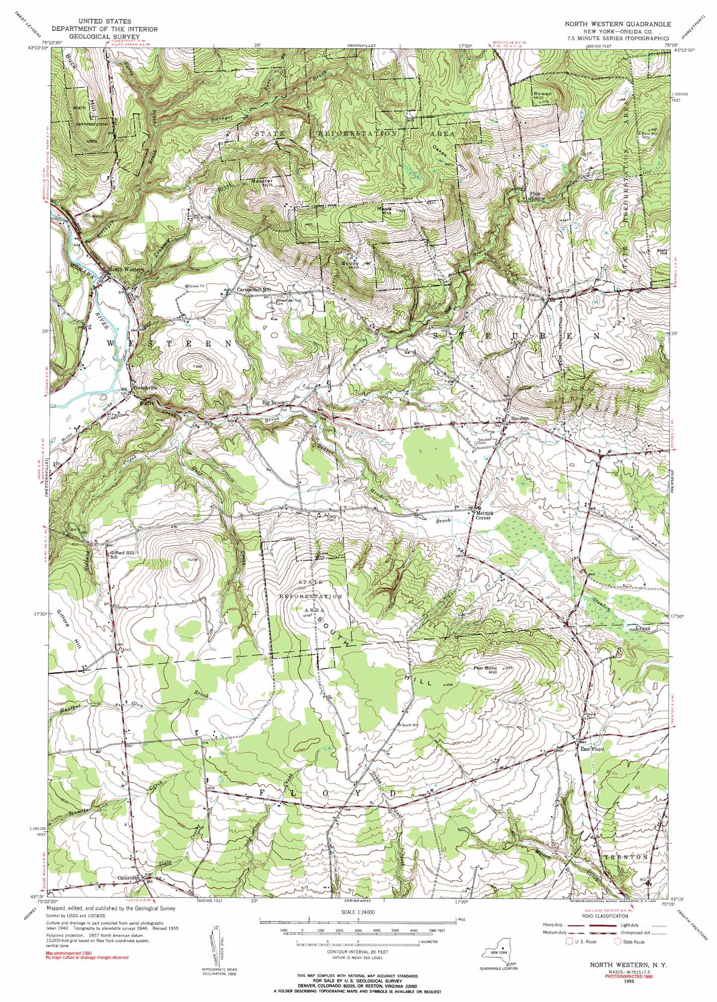
USGS Topo Quad 43075c3 - 1:24,000 scale
| Topo Map Name: | North Western |
| USGS Topo Quad ID: | 43075c3 |
| Print Size: | ca. 21 1/4" wide x 27" high |
| Southeast Coordinates: | 43.25° N latitude / 75.25° W longitude |
| Map Center Coordinates: | 43.3125° N latitude / 75.3125° W longitude |
| U.S. State: | NY |
| Filename: | o43075c3.jpg |
| Download Map JPG Image: | North Western topo map 1:24,000 scale |
| Map Type: | Topographic |
| Topo Series: | 7.5´ |
| Map Scale: | 1:24,000 |
| Source of Map Images: | United States Geological Survey (USGS) |
| Alternate Map Versions: |
North Western NY 1955, updated 1957 Download PDF Buy paper map North Western NY 1955, updated 1957 Download PDF Buy paper map North Western NY 2010 Download PDF Buy paper map North Western NY 2013 Download PDF Buy paper map North Western NY 2016 Download PDF Buy paper map |
1:24,000 Topo Quads surrounding North Western
High Market |
Constableville |
Port Leyden |
Otter Lake |
|
Point Rock |
West Leyden |
Boonville |
Forestport |
North Wilmurt |
Lee Center |
Westernville |
North Western |
Remsen |
Hinckley |
Verona |
Rome |
Oriskany |
South Trenton |
Newport |
Vernon |
Clinton |
Utica West |
Utica East |
Ilion |
> Back to 43075a1 at 1:100,000 scale
> Back to 43074a1 at 1:250,000 scale
> Back to U.S. Topo Maps home
North Western topo map: Gazetteer
North Western: Airports
Flying Acres Airport elevation 214m 702′North Western: Populated Places
Big Brook elevation 213m 698′Camroden elevation 263m 862′
Carmichael Hill elevation 257m 843′
East Floyd elevation 299m 980′
Fink Hollow elevation 365m 1197′
Frenchville elevation 182m 597′
Merrick Corner elevation 250m 820′
North Western elevation 193m 633′
Steuben elevation 283m 928′
North Western: Streams
Beaver Meadow Brook elevation 207m 679′Big Brook elevation 186m 610′
Bunt Brook elevation 290m 951′
Cyrus Brook elevation 235m 770′
Gifford Creek elevation 186m 610′
Gulf Creek elevation 193m 633′
Lansing Kill elevation 190m 623′
Stringer Brook elevation 184m 603′
Tannery Brook elevation 173m 567′
Wells Creek elevation 173m 567′
North Western: Summits
Boody Hill elevation 422m 1384′Bowen Hill elevation 538m 1765′
Buck Hill elevation 426m 1397′
Gifford Hill elevation 324m 1062′
Maple Mountain elevation 497m 1630′
Meszler Hill elevation 445m 1459′
Oakes Hill elevation 515m 1689′
Pen Bonc Hill elevation 392m 1286′
South Hill elevation 391m 1282′
North Western digital topo map on disk
Buy this North Western topo map showing relief, roads, GPS coordinates and other geographical features, as a high-resolution digital map file on DVD:
New York, Vermont, Connecticut & Western Massachusetts
Buy digital topo maps: New York, Vermont, Connecticut & Western Massachusetts