Stillwater Reservoir West Topo Map New York
To zoom in, hover over the map of Stillwater Reservoir West
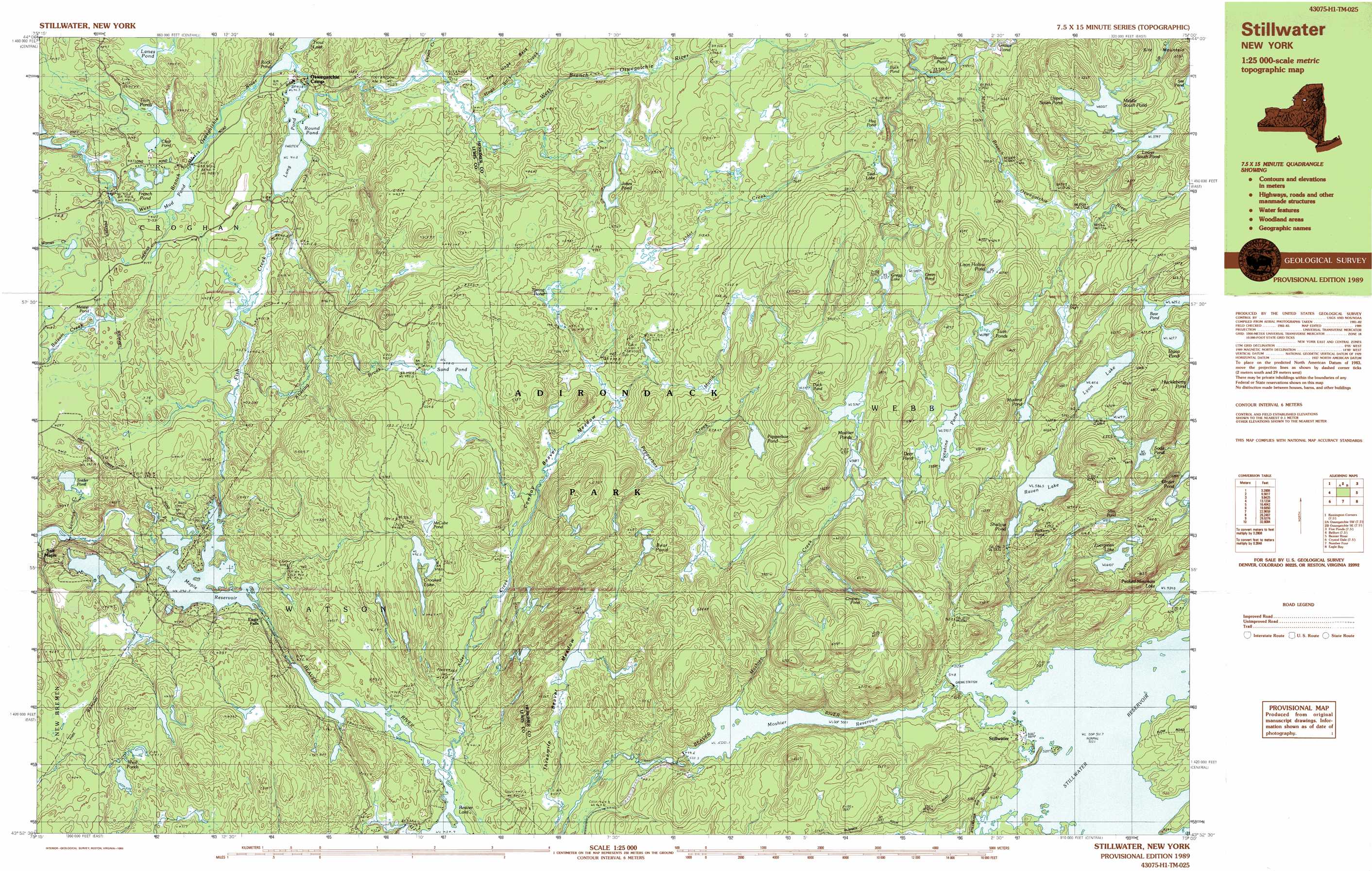
USGS Topo Quad 43075h1 - 1:25,000 scale
| Topo Map Name: | Stillwater Reservoir West |
| USGS Topo Quad ID: | 43075h1 |
| Print Size: | ca. 39" wide x 24" high |
| Southeast Coordinates: | 43.875° N latitude / 75° W longitude |
| Map Center Coordinates: | 43.9375° N latitude / 75.125° W longitude |
| U.S. State: | NY |
| Filename: | k43075h1.jpg |
| Download Map JPG Image: | Stillwater Reservoir West topo map 1:25,000 scale |
| Map Type: | Topographic |
| Topo Series: | 7.5´x15´ |
| Map Scale: | 1:25,000 |
| Source of Map Images: | United States Geological Survey (USGS) |
| Alternate Map Versions: |
Stillwater NY 1989, updated 1989 Download PDF Buy paper map |
1:24,000 Topo Quads surrounding Stillwater Reservoir West
Harrisville |
Fine |
Oswegatchie |
Newton Falls |
Cranberry Lake |
Remington Corners |
Oswegatchie Sw |
Oswegatchie Se |
Five Ponds |
Wolf Mountain |
Belfort |
Stillwater Reservoir West |
Nehasane Lake |
||
Crystal Dale |
Stillwater Mountain |
Eagle Bay |
||
Brantingham |
Thendara |
Limekiln Lake |
> Back to 43075e1 at 1:100,000 scale
> Back to 43074a1 at 1:250,000 scale
> Back to U.S. Topo Maps home
Stillwater Reservoir West topo map: Gazetteer
Stillwater Reservoir West: Flats
Cowboy Beaver Meadow elevation 473m 1551′Threemile Beaver Meadow elevation 477m 1564′
Stillwater Reservoir West: Lakes
Bear Pond elevation 528m 1732′Brindle Pond elevation 540m 1771′
Buck Pond elevation 545m 1788′
Clear Pond elevation 417m 1368′
Crooked Lake elevation 496m 1627′
Cropsey Pond elevation 591m 1938′
Deer Pond elevation 595m 1952′
Diana Pond elevation 628m 2060′
Duck Pond elevation 592m 1942′
Evergreen Lake elevation 610m 2001′
French Pond elevation 413m 1354′
Ginger Pond elevation 589m 1932′
Green Pond elevation 588m 1929′
Gregg Lake elevation 573m 1879′
Hog Pond elevation 561m 1840′
Jackson Pond elevation 587m 1925′
Jakes Pond elevation 501m 1643′
Lanes Pond elevation 421m 1381′
Long Pond elevation 411m 1348′
Loon Hollows Pond elevation 605m 1984′
Lower South Pond elevation 599m 1965′
Lyon Lake elevation 612m 2007′
McCabe Pond elevation 515m 1689′
Meister Pond elevation 413m 1354′
Middle South Pond elevation 605m 1984′
Moshier Ponds elevation 572m 1876′
Mud Pond elevation 409m 1341′
Muskrat Pond elevation 598m 1961′
Peaked Mountain Lake elevation 534m 1751′
Pepperbox Pond elevation 567m 1860′
Raven Lake elevation 586m 1922′
Rock Pond elevation 410m 1345′
Round Pond elevation 411m 1348′
Sand Pond elevation 498m 1633′
Shallow Pond elevation 587m 1925′
Slim Pond elevation 612m 2007′
Snider Pond elevation 374m 1227′
Soda Pond elevation 638m 2093′
Spring Pond elevation 501m 1643′
Sunshine Pond elevation 595m 1952′
Tied Lake elevation 568m 1863′
Twin Ponds elevation 417m 1368′
Twin Ponds elevation 598m 1961′
Upper South Pond elevation 611m 2004′
West Ponds elevation 433m 1420′
Stillwater Reservoir West: Populated Places
Soft Maple elevation 360m 1181′Stillwater elevation 515m 1689′
Stillwater Reservoir West: Reservoirs
Moshier Reservoir elevation 500m 1640′Soft Maple Reservoir elevation 390m 1279′
Stillwater Reservoir elevation 508m 1666′
Stillwater Reservoir West: Ridges
The Hogs Back elevation 494m 1620′Stillwater Reservoir West: Streams
Alder Creek elevation 435m 1427′Beaver Meadow Brook elevation 436m 1430′
Desert Creek elevation 437m 1433′
Fish Creek elevation 393m 1289′
Hogs Back Creek elevation 436m 1430′
Martin Brook elevation 478m 1568′
Moshier Creek elevation 500m 1640′
Pepperbox Creek elevation 479m 1571′
Roaring Brook elevation 406m 1332′
Sammys Creek elevation 360m 1181′
Sand Lake Outlet elevation 541m 1774′
Stillwater Reservoir West: Summits
Sitz Mountain elevation 655m 2148′Stillwater Reservoir West digital topo map on disk
Buy this Stillwater Reservoir West topo map showing relief, roads, GPS coordinates and other geographical features, as a high-resolution digital map file on DVD:
New York, Vermont, Connecticut & Western Massachusetts
Buy digital topo maps: New York, Vermont, Connecticut & Western Massachusetts