Sage Lake Topo Map Michigan
To zoom in, hover over the map of Sage Lake
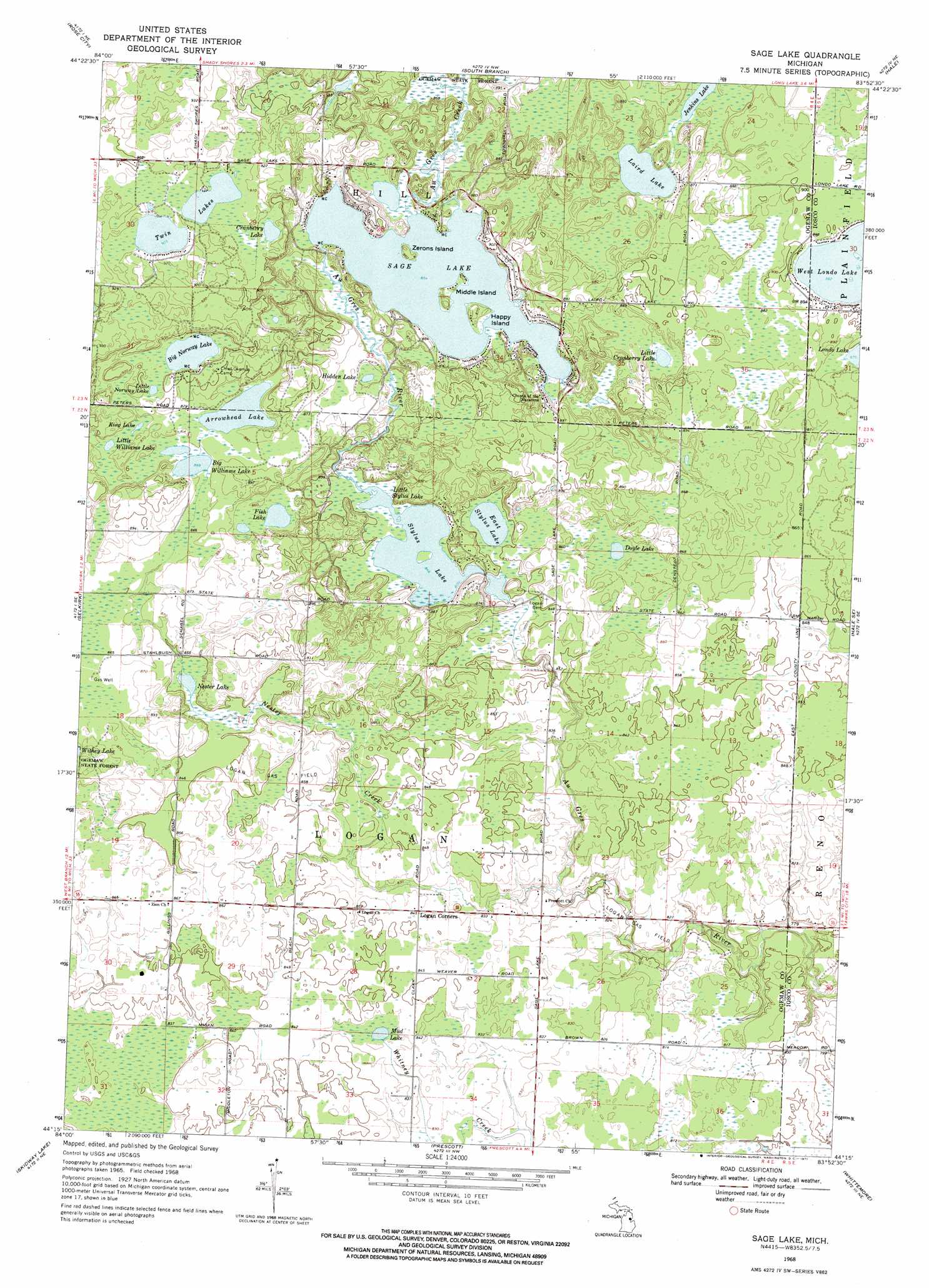
USGS Topo Quad 44083c8 - 1:24,000 scale
| Topo Map Name: | Sage Lake |
| USGS Topo Quad ID: | 44083c8 |
| Print Size: | ca. 21 1/4" wide x 27" high |
| Southeast Coordinates: | 44.25° N latitude / 83.875° W longitude |
| Map Center Coordinates: | 44.3125° N latitude / 83.9375° W longitude |
| U.S. State: | MI |
| Filename: | o44083c8.jpg |
| Download Map JPG Image: | Sage Lake topo map 1:24,000 scale |
| Map Type: | Topographic |
| Topo Series: | 7.5´ |
| Map Scale: | 1:24,000 |
| Source of Map Images: | United States Geological Survey (USGS) |
| Alternate Map Versions: |
Sage Lake MI 1968, updated 1971 Download PDF Buy paper map Sage Lake MI 2011 Download PDF Buy paper map Sage Lake MI 2014 Download PDF Buy paper map Sage Lake MI 2016 Download PDF Buy paper map |
1:24,000 Topo Quads surrounding Sage Lake
Island Lake |
Mack Lake |
Goodar |
Alcona Dam Pond |
Glennie |
Damon |
Rose City |
South Branch |
Hale |
Loud Dam |
West Branch |
Selkirk |
Sage Lake |
Hale Se |
Floyd Lake |
Sterling Nw |
Skidway Lake |
Prescott |
Whittemore |
National City |
Sterling Sw |
Sterling |
Omer Sw |
Omer |
Au Gres |
> Back to 44083a1 at 1:100,000 scale
> Back to 44082a1 at 1:250,000 scale
> Back to U.S. Topo Maps home
Sage Lake topo map: Gazetteer
Sage Lake: Islands
Happy Island elevation 264m 866′Middle Island elevation 262m 859′
Zerons Island elevation 262m 859′
Sage Lake: Lakes
Arrowhead Lake elevation 267m 875′Big Norway Lake elevation 270m 885′
Big Williams Lake elevation 265m 869′
Cranberry Lake elevation 277m 908′
Doyle Lake elevation 262m 859′
East Stylus Lake elevation 257m 843′
Fish Lake elevation 260m 853′
Hidden Lake elevation 264m 866′
Jenkins Lake elevation 260m 853′
King Lake elevation 265m 869′
Laird Lake elevation 260m 853′
Little Cranberry Lake elevation 264m 866′
Little Norway Lake elevation 271m 889′
Little Stylus Lake elevation 258m 846′
Little Williams Lake elevation 265m 869′
Mud Lake elevation 256m 839′
Nester Lake elevation 258m 846′
Sage Lake elevation 264m 866′
Stylus Lake elevation 258m 846′
Twin Lakes elevation 276m 905′
West Londo Lake elevation 269m 882′
Sage Lake: Oilfields
Logan Gas Field elevation 259m 849′Sage Lake: Post Offices
Nester Post Office (historical) elevation 253m 830′Sage Lake: Streams
Au Gres Creek elevation 261m 856′Nester Creek elevation 249m 816′
Sage Lake digital topo map on disk
Buy this Sage Lake topo map showing relief, roads, GPS coordinates and other geographical features, as a high-resolution digital map file on DVD:
 map DVD")