Hunter Peak Topo Map Wyoming
To zoom in, hover over the map of Hunter Peak
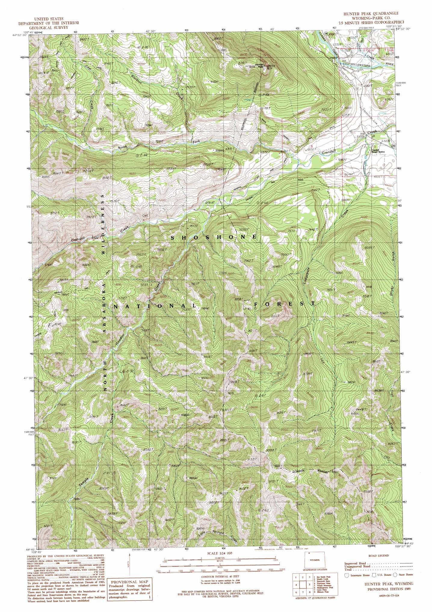
USGS Topo Quad 44109g6 - 1:24,000 scale
| Topo Map Name: | Hunter Peak |
| USGS Topo Quad ID: | 44109g6 |
| Print Size: | ca. 21 1/4" wide x 27" high |
| Southeast Coordinates: | 44.75° N latitude / 109.625° W longitude |
| Map Center Coordinates: | 44.8125° N latitude / 109.6875° W longitude |
| U.S. State: | WY |
| Filename: | o44109g6.jpg |
| Download Map JPG Image: | Hunter Peak topo map 1:24,000 scale |
| Map Type: | Topographic |
| Topo Series: | 7.5´ |
| Map Scale: | 1:24,000 |
| Source of Map Images: | United States Geological Survey (USGS) |
| Alternate Map Versions: |
Hunter Peak WY 1989, updated 1989 Download PDF Buy paper map Hunter Peak WY 1991, updated 1997 Download PDF Buy paper map Hunter Peak WY 2012 Download PDF Buy paper map Hunter Peak WY 2015 Download PDF Buy paper map |
| FStopo: | US Forest Service topo Hunter Peak is available: Download FStopo PDF Download FStopo TIF |
1:24,000 Topo Quads surrounding Hunter Peak
Cooke City |
Fossil Lake |
Castle Mountain |
Silver Run Peak |
Black Pyramid Mountain |
Pilot Peak |
Jim Smith Peak |
Muddy Creek |
Beartooth Butte |
Deep Lake |
Canoe Lake |
Hurricane Mesa |
Hunter Peak |
Windy Mountain |
Dillworth Bench |
Pollux Peak |
Stinkingwater Peak |
Geers Point |
Elkhorn Peak |
Dead Indian Meadows |
Pahaska Tepee |
Sunlight Peak |
Jaggar Peak |
Dead Indian Peak |
Jim Mountain |
> Back to 44109e1 at 1:100,000 scale
> Back to 44108a1 at 1:250,000 scale
> Back to U.S. Topo Maps home
Hunter Peak topo map: Gazetteer
Hunter Peak: Mines
Cary Pit elevation 2053m 6735′Hunter Peak: Streams
Blacktail Creek elevation 2048m 6719′Cow Creek elevation 2124m 6968′
Ghost Creek elevation 1975m 6479′
Hoodoo Creek elevation 2004m 6574′
Lodge Pole Creek elevation 1963m 6440′
North Fork Crandall Creek elevation 1981m 6499′
Temple Creek elevation 2137m 7011′
Wolverine Creek elevation 2295m 7529′
Hunter Peak: Summits
Hunter Peak elevation 2742m 8996′Hunter Peak: Trails
Crandall Cutoff Trail elevation 2015m 6610′Lodgepole Trail elevation 2501m 8205′
Hunter Peak: Valleys
Oliver Gulch elevation 2034m 6673′Hunter Peak digital topo map on disk
Buy this Hunter Peak topo map showing relief, roads, GPS coordinates and other geographical features, as a high-resolution digital map file on DVD: