Windy Mountain Topo Map Wyoming
To zoom in, hover over the map of Windy Mountain
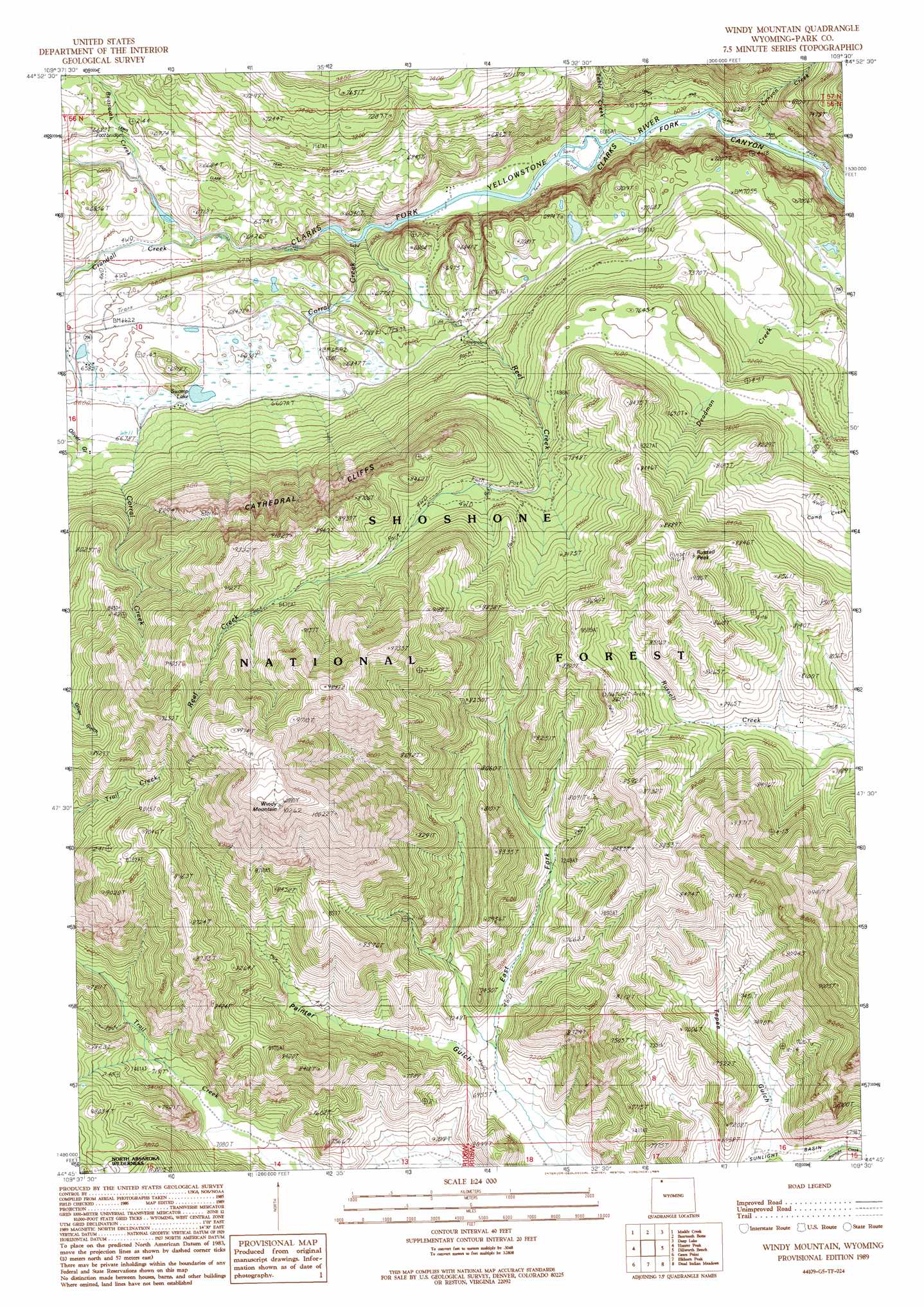
USGS Topo Quad 44109g5 - 1:24,000 scale
| Topo Map Name: | Windy Mountain |
| USGS Topo Quad ID: | 44109g5 |
| Print Size: | ca. 21 1/4" wide x 27" high |
| Southeast Coordinates: | 44.75° N latitude / 109.5° W longitude |
| Map Center Coordinates: | 44.8125° N latitude / 109.5625° W longitude |
| U.S. State: | WY |
| Filename: | o44109g5.jpg |
| Download Map JPG Image: | Windy Mountain topo map 1:24,000 scale |
| Map Type: | Topographic |
| Topo Series: | 7.5´ |
| Map Scale: | 1:24,000 |
| Source of Map Images: | United States Geological Survey (USGS) |
| Alternate Map Versions: |
Windy Mountain WY 1989, updated 1989 Download PDF Buy paper map Windy Mountain WY 1991, updated 1997 Download PDF Buy paper map Windy Mountain WY 2012 Download PDF Buy paper map Windy Mountain WY 2015 Download PDF Buy paper map |
| FStopo: | US Forest Service topo Windy Mountain is available: Download FStopo PDF Download FStopo TIF |
1:24,000 Topo Quads surrounding Windy Mountain
Fossil Lake |
Castle Mountain |
Silver Run Peak |
Black Pyramid Mountain |
Mount Maurice |
Jim Smith Peak |
Muddy Creek |
Beartooth Butte |
Deep Lake |
North Bennett Creek |
Hurricane Mesa |
Hunter Peak |
Windy Mountain |
Dillworth Bench |
Bald Peak |
Stinkingwater Peak |
Geers Point |
Elkhorn Peak |
Dead Indian Meadows |
Pat O' Hara Mountain |
Sunlight Peak |
Jaggar Peak |
Dead Indian Peak |
Jim Mountain |
Logan Mountain |
> Back to 44109e1 at 1:100,000 scale
> Back to 44108a1 at 1:250,000 scale
> Back to U.S. Topo Maps home
Windy Mountain topo map: Gazetteer
Windy Mountain: Airports
Luckinbill Airstrip elevation 2012m 6601′Windy Mountain: Cliffs
Cathedral Cliffs elevation 2455m 8054′Windy Mountain: Lakes
Swamp Lake elevation 2004m 6574′Windy Mountain: Mines
Camp Creek Quarry elevation 2153m 7063′Windy Mountain: Streams
Beartooth Creek elevation 1968m 6456′Canyon Creek elevation 1830m 6003′
Corral Creek elevation 1842m 6043′
Crandall Creek elevation 1923m 6309′
Deadman Creek elevation 2100m 6889′
Reef Creek elevation 1841m 6040′
Table Creek elevation 1835m 6020′
Windy Mountain: Summits
Russell Peak elevation 2790m 9153′Windy Mountain elevation 3121m 10239′
Windy Mountain: Trails
Lewis and Clark Trail elevation 1843m 6046′Reef Creek Trail elevation 2558m 8392′
Windy Mountain: Valleys
East Fork Painter Gulch elevation 2135m 7004′Marguerite Draw elevation 2079m 6820′
Windy Mountain digital topo map on disk
Buy this Windy Mountain topo map showing relief, roads, GPS coordinates and other geographical features, as a high-resolution digital map file on DVD: