Spur Mountain Topo Map Montana
To zoom in, hover over the map of Spur Mountain
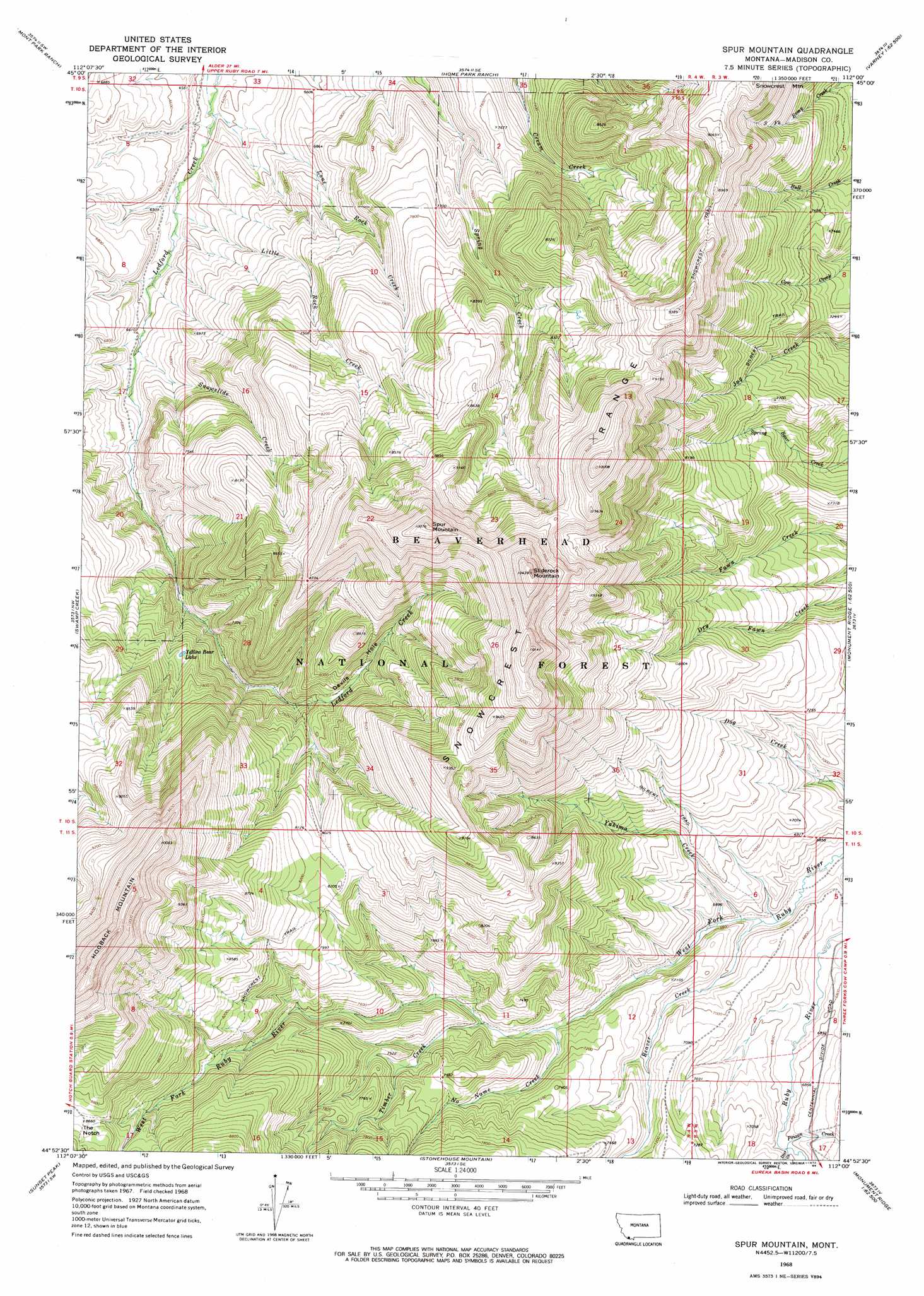
USGS Topo Quad 44112h1 - 1:24,000 scale
| Topo Map Name: | Spur Mountain |
| USGS Topo Quad ID: | 44112h1 |
| Print Size: | ca. 21 1/4" wide x 27" high |
| Southeast Coordinates: | 44.875° N latitude / 112° W longitude |
| Map Center Coordinates: | 44.9375° N latitude / 112.0625° W longitude |
| U.S. State: | MT |
| Filename: | o44112h1.jpg |
| Download Map JPG Image: | Spur Mountain topo map 1:24,000 scale |
| Map Type: | Topographic |
| Topo Series: | 7.5´ |
| Map Scale: | 1:24,000 |
| Source of Map Images: | United States Geological Survey (USGS) |
| Alternate Map Versions: |
Spur Mountain MT 1968, updated 1972 Download PDF Buy paper map Spur Mountain MT 1968, updated 1984 Download PDF Buy paper map Spur Mountain MT 1997, updated 2002 Download PDF Buy paper map Spur Mountain MT 2011 Download PDF Buy paper map Spur Mountain MT 2014 Download PDF Buy paper map |
| FStopo: | US Forest Service topo Spur Mountain is available: Download FStopo PDF Download FStopo TIF |
1:24,000 Topo Quads surrounding Spur Mountain
Mine Gulch |
Metzel Ranch |
Ruby Dam |
Cirque Lake |
Varney |
Red Canyon |
Belmont Park Ranch |
Home Park Ranch |
Warm Springs Creek |
Broomtail Ridge |
Price Creek Ne |
Swamp Creek |
Spur Mountain |
Iron Creek |
Bighorn Mountain |
Whiskey Spring |
Antone Peak |
Stonehouse Mountain |
Eureka Basin |
Windy Hill |
Lima Dam |
Wolverine Creek |
Antelope Peak |
Metzel Creek |
Lower Red Rock Lake |
> Back to 44112e1 at 1:100,000 scale
> Back to 44112a1 at 1:250,000 scale
> Back to U.S. Topo Maps home
Spur Mountain topo map: Gazetteer
Spur Mountain: Gaps
Ledoford Pass elevation 2489m 8166′Spur Mountain: Lakes
Yellow Bear Lake elevation 2324m 7624′Spur Mountain: Streams
Beaver Creek elevation 2045m 6709′Deadman Creek elevation 2046m 6712′
Deer Creek elevation 2071m 6794′
Devils Hole Creek elevation 2262m 7421′
Little Rock Creek elevation 1964m 6443′
Lone Rock Creek elevation 1939m 6361′
No Name Creek elevation 2138m 7014′
Poison Creek elevation 2071m 6794′
Snowslide Creek elevation 2011m 6597′
Timber Creek elevation 2174m 7132′
Yakima Creek elevation 2053m 6735′
Spur Mountain: Summits
Hogback Mountain elevation 3224m 10577′Sliderock Mountain elevation 3142m 10308′
Snowcrest Mountain elevation 2740m 8989′
Spur Mountain elevation 3049m 10003′
Spur Mountain digital topo map on disk
Buy this Spur Mountain topo map showing relief, roads, GPS coordinates and other geographical features, as a high-resolution digital map file on DVD: