Roberts Topo Map Montana
To zoom in, hover over the map of Roberts
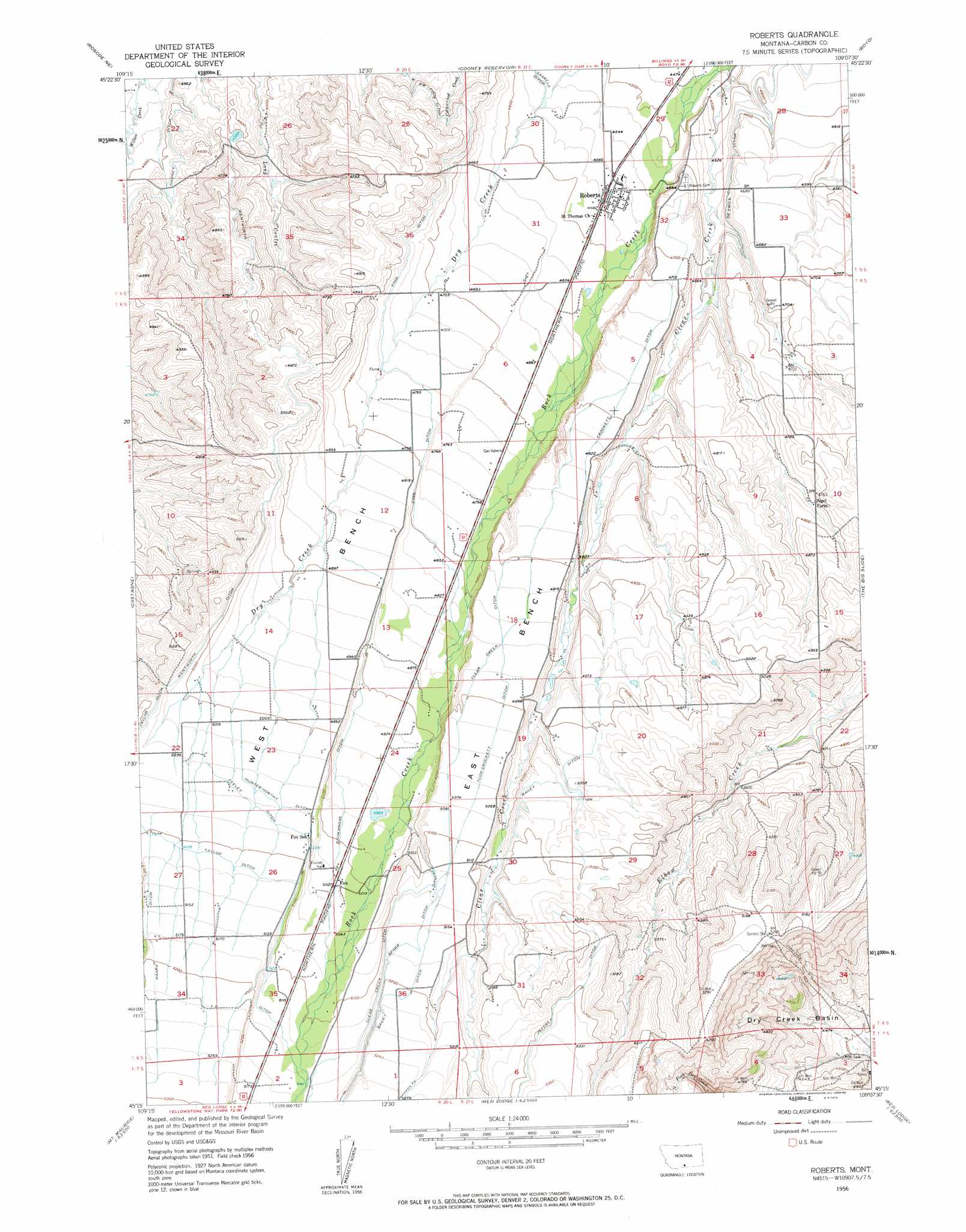
USGS Topo Quad 45109c2 - 1:24,000 scale
| Topo Map Name: | Roberts |
| USGS Topo Quad ID: | 45109c2 |
| Print Size: | ca. 21 1/4" wide x 27" high |
| Southeast Coordinates: | 45.25° N latitude / 109.125° W longitude |
| Map Center Coordinates: | 45.3125° N latitude / 109.1875° W longitude |
| U.S. State: | MT |
| Filename: | o45109c2.jpg |
| Download Map JPG Image: | Roberts topo map 1:24,000 scale |
| Map Type: | Topographic |
| Topo Series: | 7.5´ |
| Map Scale: | 1:24,000 |
| Source of Map Images: | United States Geological Survey (USGS) |
| Alternate Map Versions: |
Roberts MT 1956, updated 1958 Download PDF Buy paper map Roberts MT 2011 Download PDF Buy paper map Roberts MT 2014 Download PDF Buy paper map |
1:24,000 Topo Quads surrounding Roberts
Absarokee |
Whitebird School |
Shane Ridge |
Rapids |
Montaqua |
Roscoe Nw |
Roscoe Ne |
Cooney Reservoir |
Boyd |
Fromberg |
Roscoe |
Castagne |
Roberts |
The Big Slide |
Bridger |
Bare Mountain |
Red Lodge West |
Red Lodge East |
Belfry |
Hatcher Pass |
Black Pyramid Mountain |
Mount Maurice |
Tolman Flat |
Hollenbeck Draw |
Long Draw |
> Back to 45109a1 at 1:100,000 scale
> Back to 45108a1 at 1:250,000 scale
> Back to U.S. Topo Maps home
Roberts topo map: Gazetteer
Roberts: Basins
Dry Creek Basin elevation 1350m 4429′Roberts: Benches
East Bench elevation 1552m 5091′West Bench elevation 1510m 4954′
Roberts: Bridges
Rock Creek Bridge elevation 1382m 4534′Roberts: Canals
Bailey Ditch elevation 1593m 5226′Clear Creek Ditch elevation 1566m 5137′
Crockett Ditch elevation 1463m 4799′
DeVries Ditch elevation 1400m 4593′
Feeley Ditch elevation 1544m 5065′
Finn Ditch elevation 1450m 4757′
Harney Ditch elevation 1382m 4534′
Hunter-Northy Ditch elevation 1541m 5055′
Jeffrey Ditch elevation 1621m 5318′
Kivikangas Ditch elevation 1512m 4960′
Sparr Ditch elevation 1585m 5200′
Tuck-Crockett Ditch elevation 1517m 4977′
Wentworth Ditch elevation 1510m 4954′
Roberts: Populated Places
Fox elevation 1532m 5026′Roberts elevation 1395m 4576′
Roberts: Post Offices
Roberts Post Office elevation 1395m 4576′Roberts: Wells
05S21E29DBCB01 Well elevation 1371m 4498′Roberts digital topo map on disk
Buy this Roberts topo map showing relief, roads, GPS coordinates and other geographical features, as a high-resolution digital map file on DVD: