Twin Bridges Topo Map Montana
To zoom in, hover over the map of Twin Bridges
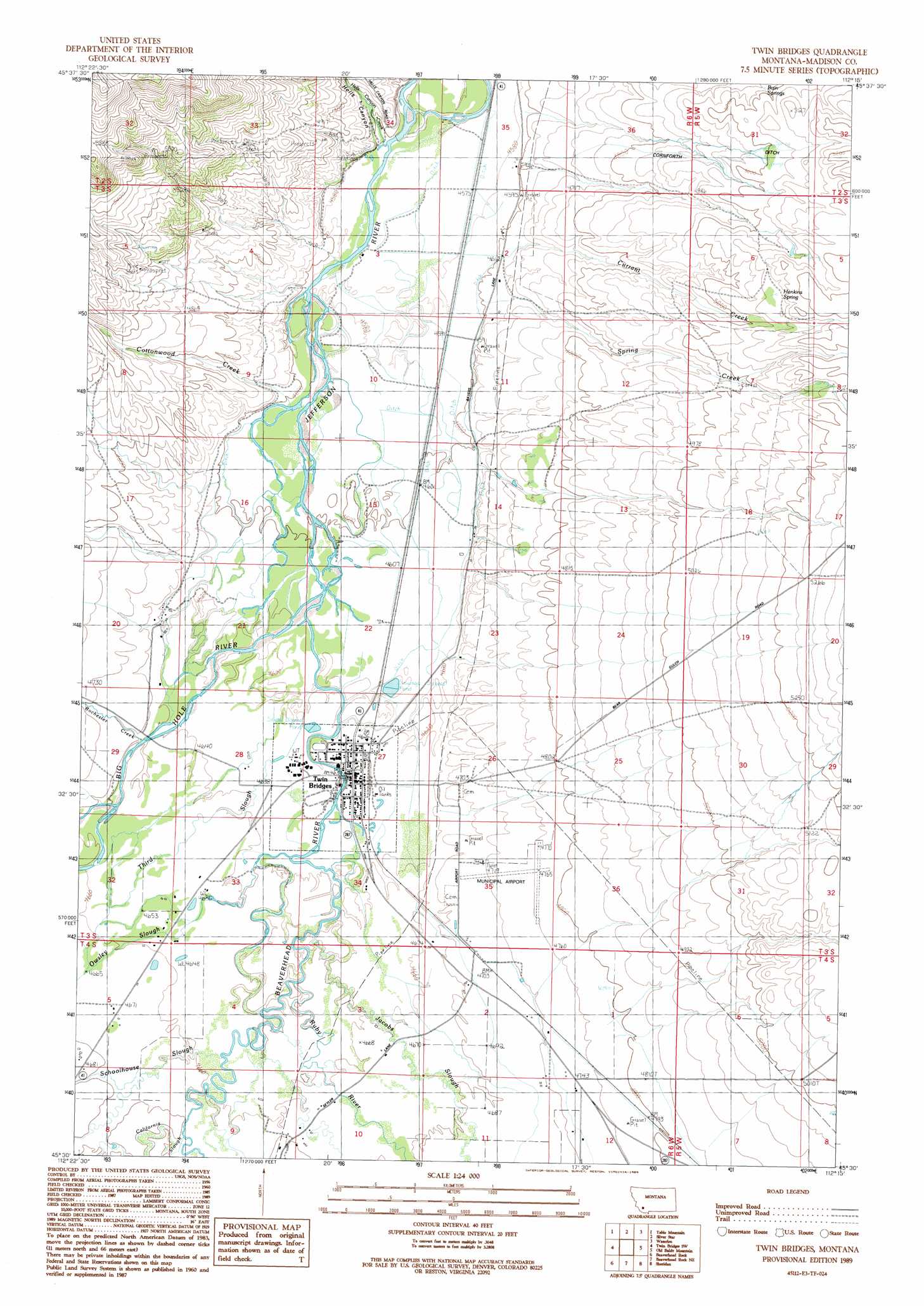
USGS Topo Quad 45112e3 - 1:24,000 scale
| Topo Map Name: | Twin Bridges |
| USGS Topo Quad ID: | 45112e3 |
| Print Size: | ca. 21 1/4" wide x 27" high |
| Southeast Coordinates: | 45.5° N latitude / 112.25° W longitude |
| Map Center Coordinates: | 45.5625° N latitude / 112.3125° W longitude |
| U.S. State: | MT |
| Filename: | o45112e3.jpg |
| Download Map JPG Image: | Twin Bridges topo map 1:24,000 scale |
| Map Type: | Topographic |
| Topo Series: | 7.5´ |
| Map Scale: | 1:24,000 |
| Source of Map Images: | United States Geological Survey (USGS) |
| Alternate Map Versions: |
Twin Bridges MT 1989, updated 1989 Download PDF Buy paper map Twin Bridges MT 2011 Download PDF Buy paper map Twin Bridges MT 2014 Download PDF Buy paper map |
| FStopo: | US Forest Service topo Twin Bridges is available: Download FStopo PDF Download FStopo TIF |
1:24,000 Topo Quads surrounding Twin Bridges
Mount Humbug |
Pipestone Pass |
Grace |
Vendome |
Whitehall |
Wickiup Creek |
Table Mountain |
Silver Star |
Waterloo |
Manhead Mountain |
Nez Perce Hollow |
Twin Bridges Sw |
Twin Bridges |
Old Baldy Mountain |
Noble Peak |
Block Mountain |
Beaverhead Rock |
Beaverhead Rock Ne |
Sheridan |
Copper Mountain |
Glen Se |
Beaverhead Rock Sw |
Beaverhead Rock Se |
Laurin Canyon |
Alder |
> Back to 45112e1 at 1:100,000 scale
> Back to 45112a1 at 1:250,000 scale
> Back to U.S. Topo Maps home
Twin Bridges topo map: Gazetteer
Twin Bridges: Airports
Twin Bridges Airport elevation 1438m 4717′Twin Bridges: Canals
Bayers Ditch elevation 1408m 4619′Eastman Ditch elevation 1422m 4665′
Lewis-Jenkins Ditch elevation 1441m 4727′
Seyler-Tash Ditch elevation 1436m 4711′
Tash Drain Ditch elevation 1419m 4655′
Twin Bridges: Parks
Jefferson Valley Historical Marker elevation 1391m 4563′Twin Bridges City Park elevation 1410m 4625′
Twin Bridges: Populated Places
Twin Bridges elevation 1410m 4625′Twin Bridges: Post Offices
Salisbury Post Office (historical) elevation 1428m 4685′Twin Bridges Post Office elevation 1410m 4625′
Twin Bridges: Springs
Bain Springs elevation 1522m 4993′Hankins Spring elevation 1556m 5104′
Twin Bridges: Streams
Beaverhead River elevation 1405m 4609′Big Hole River elevation 1405m 4609′
California Slough elevation 1422m 4665′
Cottonwood Creek elevation 1401m 4596′
Currant Creek elevation 1408m 4619′
Hells Canyon Creek elevation 1400m 4593′
Jacobs Slough elevation 1415m 4642′
Owsley Slough elevation 1415m 4642′
Rochester Creek elevation 1415m 4642′
Ruby River elevation 1415m 4642′
Schoolhouse Slough elevation 1419m 4655′
Spring Creek elevation 1391m 4563′
Spring Creek elevation 1427m 4681′
Third Slough elevation 1409m 4622′
Twin Bridges: Valleys
Dry Georgia Gulch elevation 1440m 4724′Dry Gulch elevation 1585m 5200′
Goodrich Gulch elevation 1488m 4881′
Twin Bridges: Wells
02S06W35DCB_01 Well elevation 1402m 4599′03S05W18DBCA01 Well elevation 1569m 5147′
03S06W11BAAA01 Well elevation 1413m 4635′
03S06W35BDAB01 Well elevation 1437m 4714′
Twin Bridges digital topo map on disk
Buy this Twin Bridges topo map showing relief, roads, GPS coordinates and other geographical features, as a high-resolution digital map file on DVD: