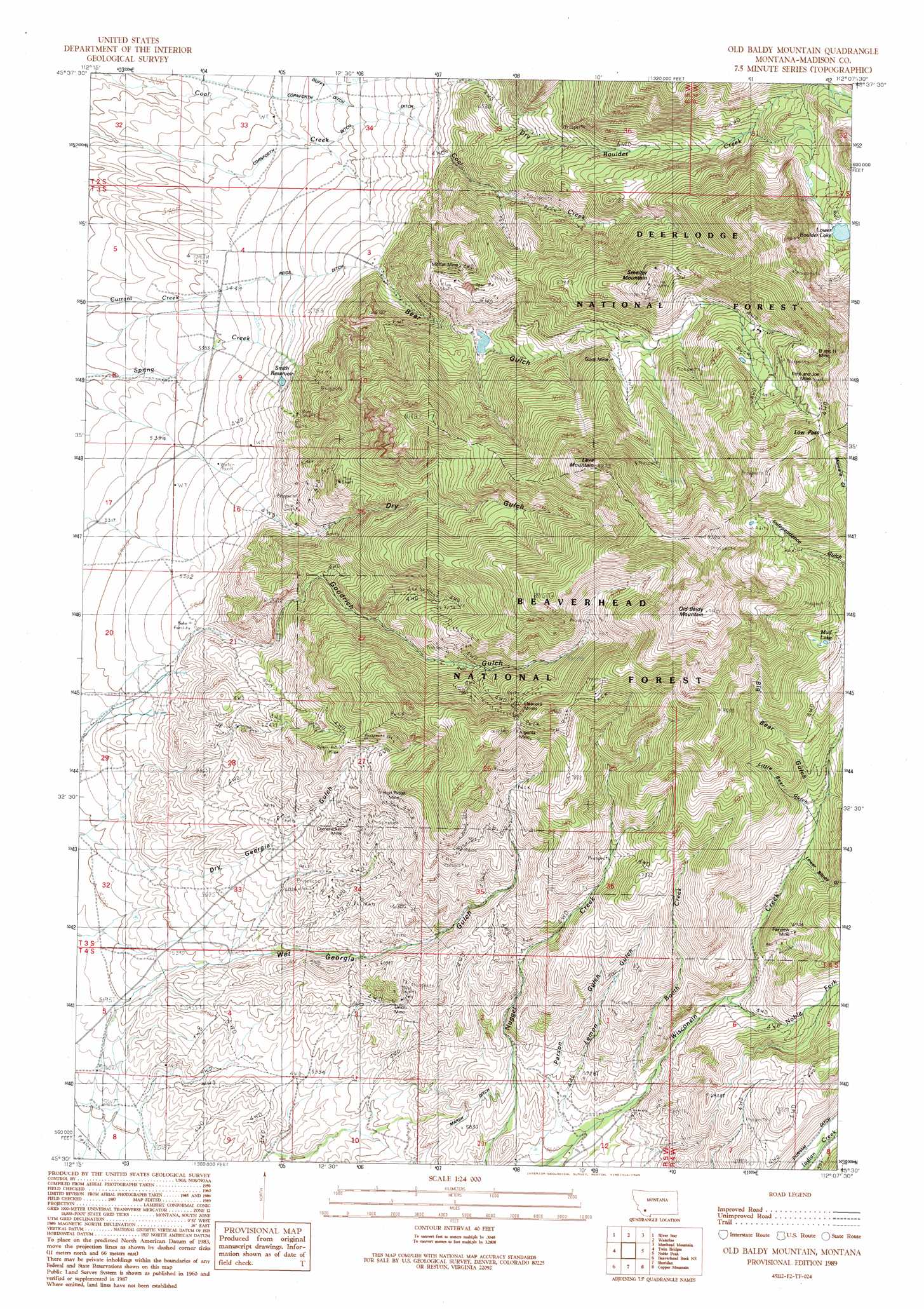
Old Baldy Mountain Topo Map Montana
To zoom in, hover over the map of Old Baldy Mountain
USGS Topo Quad 45112e2 - 1:24,000 scale
| Topo Map Name: | Old Baldy Mountain |
| USGS Topo Quad ID: | 45112e2 |
| Print Size: | ca. 21 1/4" wide x 27" high |
| Southeast Coordinates: | 45.5° N latitude / 112.125° W longitude |
| Map Center Coordinates: | 45.5625° N latitude / 112.1875° W longitude |
| U.S. State: | MT |
| Filename: | o45112e2.jpg |
| Download Map JPG Image: | Old Baldy Mountain topo map 1:24,000 scale |
| Map Type: | Topographic |
| Topo Series: | 7.5´ |
| Map Scale: | 1:24,000 |
| Source of Map Images: | United States Geological Survey (USGS) |
| Alternate Map Versions: |
Old Baldy Mountain MT 1989, updated 1989 Download PDF Buy paper map Old Baldy Mountain MT 1997, updated 2002 Download PDF Buy paper map Old Baldy Mountain MT 2011 Download PDF Buy paper map Old Baldy Mountain MT 2014 Download PDF Buy paper map |
| FStopo: | US Forest Service topo Old Baldy Mountain is available: Download FStopo PDF Download FStopo TIF |
1:24,000 Topo Quads surrounding Old Baldy Mountain
Pipestone Pass |
Grace |
Vendome |
Whitehall |
Jefferson Island |
Table Mountain |
Silver Star |
Waterloo |
Manhead Mountain |
Pony |
Twin Bridges Sw |
Twin Bridges |
Old Baldy Mountain |
Noble Peak |
Potosi Peak |
Beaverhead Rock |
Beaverhead Rock Ne |
Sheridan |
Copper Mountain |
Ramshorn Mountain |
Beaverhead Rock Sw |
Beaverhead Rock Se |
Laurin Canyon |
Alder |
Virginia City |
> Back to 45112e1 at 1:100,000 scale
> Back to 45112a1 at 1:250,000 scale
> Back to U.S. Topo Maps home
Old Baldy Mountain topo map: Gazetteer
Old Baldy Mountain: Canals
Cornforth Ditch elevation 1594m 5229′Marsh Ditch elevation 1741m 5711′
Reids Ditch elevation 1669m 5475′
Old Baldy Mountain: Gaps
Low Pass elevation 2756m 9041′Old Baldy Mountain: Lakes
Lower Boulder Lake elevation 2590m 8497′Mud Lake elevation 2464m 8083′
Old Baldy Mountain: Mines
Argenta Mine elevation 2067m 6781′Argenta Mine elevation 2464m 8083′
B and H Mine elevation 2712m 8897′
B and H Mine elevation 2683m 8802′
Booth Creek Mine elevation 1888m 6194′
Brimstone Mine elevation 1859m 6099′
Chapman Mine elevation 1993m 6538′
Coal Creek Mine elevation 1906m 6253′
Corn Cracker Mine elevation 1988m 6522′
Corncraker Mine elevation 2092m 6863′
Deutschland Mine elevation 1841m 6040′
Dry Gulch North Mine elevation 1953m 6407′
Dry Gulch South Mine elevation 1895m 6217′
Eleanor East Mine elevation 2377m 7798′
Eleanor West Mine elevation 2255m 7398′
Eleanora Mines elevation 2362m 7749′
Fairview Mine elevation 2102m 6896′
Fairview Mine elevation 2011m 6597′
Giant Mine elevation 2230m 7316′
Giant Mine elevation 2276m 7467′
Grouse Mine elevation 2565m 8415′
High Ridge Mine elevation 2092m 6863′
High Ridge Mine elevation 2167m 7109′
Keynote Mine elevation 1980m 6496′
Lemon Gulch Mine elevation 1735m 5692′
Moffat Mine elevation 2138m 7014′
Moffat Mine elevation 2097m 6879′
Montana Gulch Mine elevation 2579m 8461′
Moonlight Mine elevation 2007m 6584′
NE NE Section 33 Mine elevation 1956m 6417′
NE NE Section 7 Mine elevation 2121m 6958′
NE SW Section 34 Mine elevation 1760m 5774′
NE SW Section 35 Mine elevation 2468m 8097′
North Fork Goodrich Mine elevation 2105m 6906′
Nuggett Creek Mine elevation 1911m 6269′
NW NE Section 18 Mine elevation 2860m 9383′
NW NW Section 27 Mine elevation 1978m 6489′
NW NW Section 28 Mine elevation 1743m 5718′
NW NW Section 7 Mine elevation 1908m 6259′
NW SE Section 26 Mine elevation 2282m 7486′
NW SE Section 27 Mine elevation 2092m 6863′
NW SE Section 7 Mine elevation 2830m 9284′
NW SW Section 34 Mine elevation 1805m 5921′
NW SW Section 7 Mine elevation 2576m 8451′
Parson Gulch Mine elevation 1908m 6259′
Pete and Joe Mine elevation 2684m 8805′
Pete and Joe Mine elevation 2881m 9452′
SE NW Section 24 Mine elevation 2398m 7867′
SE NW Section 27 Mine elevation 2184m 7165′
SE SW Section 26 Mine elevation 2424m 7952′
Smelter Mountain Mine elevation 2366m 7762′
Smith Reservoir Mine elevation 1882m 6174′
SW NE Section 2 Mine elevation 2106m 6909′
SW NE Section 27 Mine elevation 1920m 6299′
SW SW Section 10 Mine elevation 1862m 6108′
SW SW Section 22 Mine elevation 1994m 6541′
Tidal Wave Mine elevation 1821m 5974′
Union Mine elevation 1786m 5859′
Union Mine elevation 1804m 5918′
West Section 28 Mine elevation 2314m 7591′
Wet Georgia Gulch Mine elevation 2027m 6650′
Whiskey Jack Mine elevation 1828m 5997′
Old Baldy Mountain: Reservoirs
Smith Reservoir elevation 1736m 5695′Old Baldy Mountain: Streams
Booth Creek elevation 1804m 5918′Noble Fork elevation 1871m 6138′
Old Baldy Mountain: Summits
Lava Mountain elevation 2820m 9251′Old Baldy Mountain elevation 3010m 9875′
Smelter Mountain elevation 2622m 8602′
Old Baldy Mountain: Valleys
Bear Gulch elevation 1813m 5948′Big Bear Gulch elevation 2089m 6853′
Lemon Gulch elevation 1735m 5692′
Little Bear Gulch elevation 2078m 6817′
Lowel Bitney Gulch elevation 2034m 6673′
Parson Gulch elevation 1715m 5626′
Upper Bitney Gulch elevation 2168m 7112′
Upper Bitney Gulch elevation 2131m 6991′
Old Baldy Mountain digital topo map on disk
Buy this Old Baldy Mountain topo map showing relief, roads, GPS coordinates and other geographical features, as a high-resolution digital map file on DVD: