Granite Butte Topo Map Montana
To zoom in, hover over the map of Granite Butte
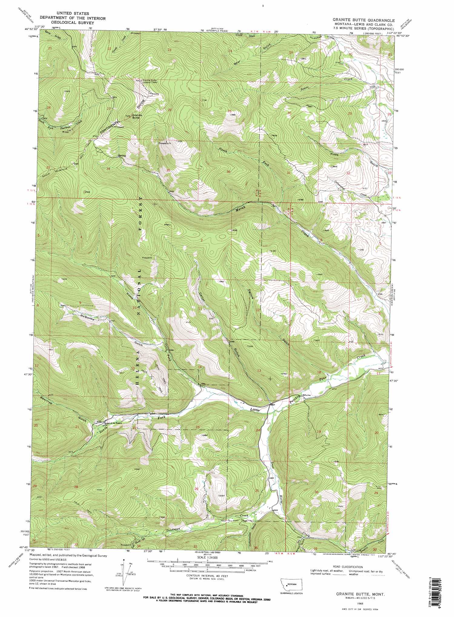
USGS Topo Quad 46112g4 - 1:24,000 scale
| Topo Map Name: | Granite Butte |
| USGS Topo Quad ID: | 46112g4 |
| Print Size: | ca. 21 1/4" wide x 27" high |
| Southeast Coordinates: | 46.75° N latitude / 112.375° W longitude |
| Map Center Coordinates: | 46.8125° N latitude / 112.4375° W longitude |
| U.S. State: | MT |
| Filename: | o46112g4.jpg |
| Download Map JPG Image: | Granite Butte topo map 1:24,000 scale |
| Map Type: | Topographic |
| Topo Series: | 7.5´ |
| Map Scale: | 1:24,000 |
| Source of Map Images: | United States Geological Survey (USGS) |
| Alternate Map Versions: |
Granite Butte MT 1968, updated 1971 Download PDF Buy paper map Granite Butte MT 1968, updated 1972 Download PDF Buy paper map Granite Butte MT 1968, updated 1972 Download PDF Buy paper map Granite Butte MT 2001, updated 2004 Download PDF Buy paper map Granite Butte MT 2011 Download PDF Buy paper map Granite Butte MT 2014 Download PDF Buy paper map |
| FStopo: | US Forest Service topo Granite Butte is available: Download FStopo PDF Download FStopo TIF |
1:24,000 Topo Quads surrounding Granite Butte
Stonewall Mountain |
Silver King Mountain |
Cadotte Creek |
Rogers Pass |
Roberts Mountain |
Lincoln |
Swede Gulch |
Stemple Pass |
Wilborn |
Mitchell Mountain |
Finn |
Nevada Mountain |
Granite Butte |
Canyon Creek |
Silver City |
Gravely Mountain |
Ophir Creek |
Esmeralda Hill |
Greenhorn Mountain |
Austin |
Luke Mountain |
Avon |
Elliston |
Macdonald Pass |
Black Mountain |
> Back to 46112e1 at 1:100,000 scale
> Back to 46112a1 at 1:250,000 scale
> Back to U.S. Topo Maps home
Granite Butte topo map: Gazetteer
Granite Butte: Canals
Pilgeram Ditch elevation 1608m 5275′Granite Butte: Falls
Paradise Falls elevation 1639m 5377′Granite Butte: Mines
Brooks Mine elevation 1735m 5692′Crown Mine elevation 2139m 7017′
Gold Coin Mine elevation 2133m 6998′
Granite Butte Lookout Mine elevation 2265m 7431′
Highland Chief Mine elevation 1652m 5419′
Highland Placer Mine elevation 1604m 5262′
Highland View Mine elevation 1750m 5741′
Iron Cliff Mine elevation 1866m 6122′
LKL Number 35 Mine elevation 1790m 5872′
NE NW Section 35 Mine elevation 2115m 6938′
NW NW Section 35 Mine elevation 1790m 5872′
Prize Mine elevation 2113m 6932′
SE SE Section 28 Mine elevation 1892m 6207′
SE SW Section 27 Mine elevation 2072m 6797′
SW NW Section 26 Mine elevation 2219m 7280′
SW NW Section 36 Mine elevation 1999m 6558′
SW SE Section 13 Mine elevation 1740m 5708′
SW SE Section 22 Mine elevation 1844m 6049′
SW SW Section 17 Mine elevation 1567m 5141′
SW SW Section 30 Mine elevation 1551m 5088′
Granite Butte: Populated Places
Atlantic City (historical) elevation 1467m 4812′Granite Butte: Post Offices
Millersville Post Office (historical) elevation 1592m 5223′Granite Butte: Ridges
Cayuse Ridge elevation 1796m 5892′Granite Butte: Streams
Deadman Creek elevation 1484m 4868′Left Hand Fork Deadman Creek elevation 1612m 5288′
Lost Horse Creek elevation 1453m 4767′
North Fork Little Prickly Pear Creek elevation 1477m 4845′
North Fork Marsh Creek elevation 1548m 5078′
South Fork Little Prickly Pear Creek elevation 1477m 4845′
Granite Butte: Summits
Granite Butte elevation 2313m 7588′Granite Butte: Valleys
Beartrap Gulch elevation 1548m 5078′Cellar Gulch elevation 1466m 4809′
Cottonwood Gulch elevation 1520m 4986′
Dry Gulch elevation 1538m 5045′
Left Hand Fork Dry Gulch elevation 1559m 5114′
McQuithy Gulch elevation 1526m 5006′
Ogilvie Gulch elevation 1435m 4708′
Right Hand Fork Dry Gulch elevation 1560m 5118′
Tongue Gulch elevation 1530m 5019′
Granite Butte: Wells
12N06W32ABDC01 Well elevation 1636m 5367′Granite Butte digital topo map on disk
Buy this Granite Butte topo map showing relief, roads, GPS coordinates and other geographical features, as a high-resolution digital map file on DVD: