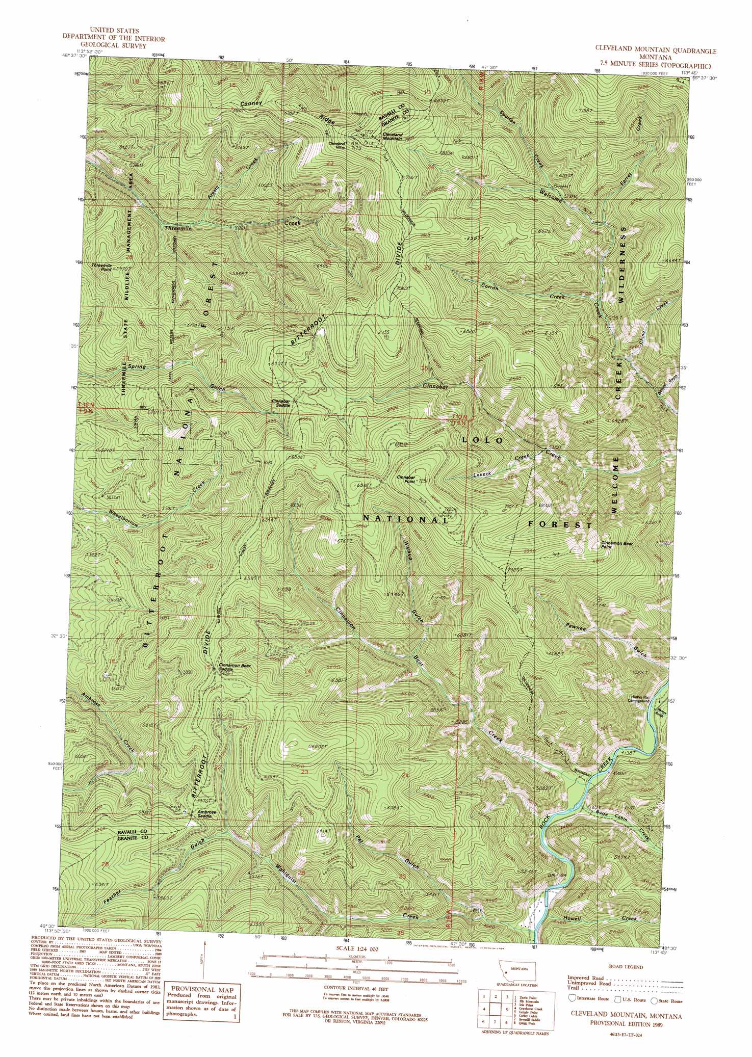
Cleveland Mountain Topo Map Montana
To zoom in, hover over the map of Cleveland Mountain
USGS Topo Quad 46113e7 - 1:24,000 scale
| Topo Map Name: | Cleveland Mountain |
| USGS Topo Quad ID: | 46113e7 |
| Print Size: | ca. 21 1/4" wide x 27" high |
| Southeast Coordinates: | 46.5° N latitude / 113.75° W longitude |
| Map Center Coordinates: | 46.5625° N latitude / 113.8125° W longitude |
| U.S. State: | MT |
| Filename: | o46113e7.jpg |
| Download Map JPG Image: | Cleveland Mountain topo map 1:24,000 scale |
| Map Type: | Topographic |
| Topo Series: | 7.5´ |
| Map Scale: | 1:24,000 |
| Source of Map Images: | United States Geological Survey (USGS) |
| Alternate Map Versions: |
Cleveland Mountain MT 1989, updated 1989 Download PDF Buy paper map Cleveland Mountain MT 1999, updated 2003 Download PDF Buy paper map Cleveland Mountain MT 2011 Download PDF Buy paper map Cleveland Mountain MT 2014 Download PDF Buy paper map |
| FStopo: | US Forest Service topo Cleveland Mountain is available: Download FStopo PDF Download FStopo TIF |
1:24,000 Topo Quads surrounding Cleveland Mountain
Southwest Missoula |
Southeast Missoula |
Bonner |
Clinton |
Mineral Ridge |
Florence |
Davis Point |
Elk Mountain |
Iris Point |
Ravenna |
Stevensville |
Grayhorse Creek |
Cleveland Mountain |
Grizzly Point |
Spink Point |
Bing |
Corley Gulch |
Sawmill Saddle |
Quigg Peak |
Alder Gulch |
Corvallis |
Willow Mountain |
Burnt Fork Lake |
Stony Creek |
Cornish Gulch |
> Back to 46113e1 at 1:100,000 scale
> Back to 46112a1 at 1:250,000 scale
> Back to U.S. Topo Maps home
Cleveland Mountain topo map: Gazetteer
Cleveland Mountain: Gaps
Ambrose Saddle elevation 1795m 5889′Cinnabar Saddle elevation 1974m 6476′
Cinnamon Bear Saddle elevation 1964m 6443′
Welcome Sawmill Saddle elevation 1924m 6312′
Cleveland Mountain: Mines
Cleveland Mine elevation 2187m 7175′Cleveland Mine elevation 2182m 7158′
Cleveland Mountain: Ridges
Bitterroot Divide elevation 2053m 6735′Cooney Ridge elevation 1988m 6522′
Cleveland Mountain: Streams
Arasta Creek elevation 1562m 5124′Butte Cabin Creek elevation 1268m 4160′
Carron Creek elevation 1583m 5193′
Chino Creek elevation 1503m 4931′
Cinnamon Bear Creek elevation 1265m 4150′
Ferret Creek elevation 1699m 5574′
Howell Creek elevation 1295m 4248′
Laveck Creek elevation 1626m 5334′
Spartan Creek elevation 1761m 5777′
Wahlquist Creek elevation 1290m 4232′
Cleveland Mountain: Summits
Cinnabar Point elevation 2207m 7240′Cinnamon Bear Point elevation 2158m 7080′
Cleveland Mountain elevation 2234m 7329′
Threemile Point elevation 1811m 5941′
Cleveland Mountain: Valleys
Bidwell Gulch elevation 1451m 4760′Feather Gulch elevation 1700m 5577′
Harrys Gulch elevation 1265m 4150′
Pat Gulch elevation 1377m 4517′
Pawnee Gulch elevation 1295m 4248′
Walkup Gulch elevation 1549m 5082′
Cleveland Mountain digital topo map on disk
Buy this Cleveland Mountain topo map showing relief, roads, GPS coordinates and other geographical features, as a high-resolution digital map file on DVD: