Walla Walla Topo Map Washington
To zoom in, hover over the map of Walla Walla
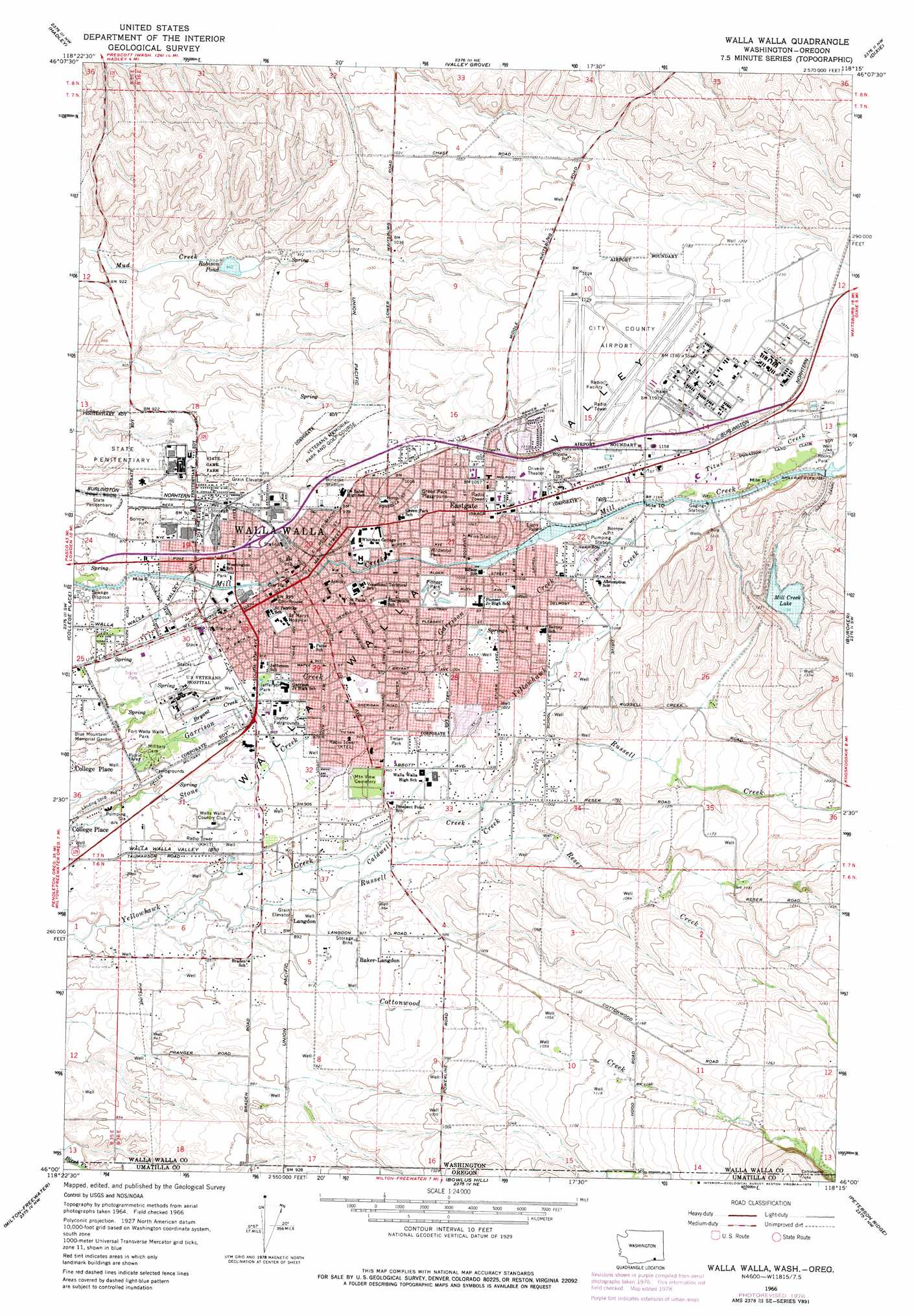
USGS Topo Quad 46118a3 - 1:24,000 scale
| Topo Map Name: | Walla Walla |
| USGS Topo Quad ID: | 46118a3 |
| Print Size: | ca. 21 1/4" wide x 27" high |
| Southeast Coordinates: | 46° N latitude / 118.25° W longitude |
| Map Center Coordinates: | 46.0625° N latitude / 118.3125° W longitude |
| U.S. States: | WA, OR |
| Filename: | o46118a3.jpg |
| Download Map JPG Image: | Walla Walla topo map 1:24,000 scale |
| Map Type: | Topographic |
| Topo Series: | 7.5´ |
| Map Scale: | 1:24,000 |
| Source of Map Images: | United States Geological Survey (USGS) |
| Alternate Map Versions: |
Walla Walla WA 1966, updated 1968 Download PDF Buy paper map Walla Walla WA 1966, updated 1978 Download PDF Buy paper map Walla Walla WA 1998, updated 2003 Download PDF Buy paper map Walla Walla WA 2011 Download PDF Buy paper map Walla Walla WA 2014 Download PDF Buy paper map |
1:24,000 Topo Quads surrounding Walla Walla
Eureka |
Harsha |
Prescott |
Waitsburg |
Huntsville |
Rulo |
Hadley |
Valley Grove |
Dixie |
Coppei |
Lowden |
College Place |
Walla Walla |
Buroker |
Kooskooskie |
Waterman |
Milton-Freewater |
Bowlus Hill |
Peterson Ridge |
Big Meadows |
Adams |
Athena |
Weston Mountain |
Blalock Mountain |
Tollgate |
> Back to 46118a1 at 1:100,000 scale
> Back to 46118a1 at 1:250,000 scale
> Back to U.S. Topo Maps home
Walla Walla topo map: Gazetteer
Walla Walla: Airports
Page Airport elevation 246m 807′Sky Ranch Landing Strip elevation 262m 859′
Walla Walla City/County Airport elevation 355m 1164′
Walla Walla General Hospital Heliport elevation 293m 961′
Walla Walla: Canals
Mill Creek Channel elevation 315m 1033′Walla Walla: Dams
Mill Creek Dam elevation 365m 1197′Mill Creek Diversion Dam elevation 383m 1256′
Robison Dam elevation 288m 944′
Twin Reservoirs Dam elevation 389m 1276′
Walla Walla: Parks
Borleske Stadium elevation 298m 977′Fort Walla Walla Park elevation 262m 859′
Jefferson Park elevation 281m 921′
Lions Park elevation 332m 1089′
Mill Creek Reservation State Wildlife Recreation Area elevation 365m 1197′
Pioneer Park elevation 314m 1030′
Tietan Park elevation 298m 977′
Wildwood Park elevation 312m 1023′
Walla Walla: Populated Places
Baker-Langdon elevation 287m 941′Langdon elevation 275m 902′
Walla Walla elevation 287m 941′
Walla Walla: Reservoirs
Mill Creek Lake elevation 365m 1197′Robison Pond elevation 288m 944′
Walla Walla: Streams
Bryant Creek elevation 266m 872′Caldwell Creek elevation 273m 895′
Cottonwood Creek elevation 248m 813′
Cottonwood Creek elevation 248m 813′
Reser Creek elevation 288m 944′
Reser Creek elevation 288m 944′
Russell Creek elevation 263m 862′
Russell Creek elevation 263m 862′
Titus Creek elevation 354m 1161′
Walla Walla digital topo map on disk
Buy this Walla Walla topo map showing relief, roads, GPS coordinates and other geographical features, as a high-resolution digital map file on DVD: