North Bend Topo Map Washington
To zoom in, hover over the map of North Bend
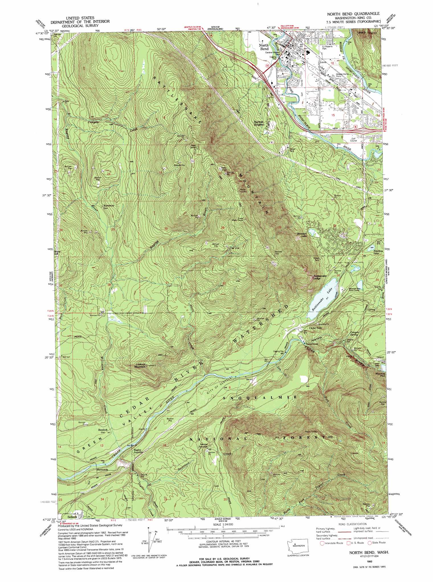
USGS Topo Quad 47121d7 - 1:24,000 scale
| Topo Map Name: | North Bend |
| USGS Topo Quad ID: | 47121d7 |
| Print Size: | ca. 21 1/4" wide x 27" high |
| Southeast Coordinates: | 47.375° N latitude / 121.75° W longitude |
| Map Center Coordinates: | 47.4375° N latitude / 121.8125° W longitude |
| U.S. State: | WA |
| Filename: | o47121d7.jpg |
| Download Map JPG Image: | North Bend topo map 1:24,000 scale |
| Map Type: | Topographic |
| Topo Series: | 7.5´ |
| Map Scale: | 1:24,000 |
| Source of Map Images: | United States Geological Survey (USGS) |
| Alternate Map Versions: |
North Bend WA 1953, updated 1955 Download PDF Buy paper map North Bend WA 1953, updated 1960 Download PDF Buy paper map North Bend WA 1953, updated 1969 Download PDF Buy paper map North Bend WA 1953, updated 1977 Download PDF Buy paper map North Bend WA 1993, updated 1993 Download PDF Buy paper map North Bend WA 1993, updated 1993 Download PDF Buy paper map North Bend WA 2011 Download PDF Buy paper map North Bend WA 2014 Download PDF Buy paper map |
| FStopo: | US Forest Service topo North Bend is available: Download FStopo PDF Download FStopo TIF |
1:24,000 Topo Quads surrounding North Bend
Redmond |
Carnation |
Lake Joy |
Tolt Reservoir |
Mount Phelps |
Issaquah |
Fall City |
Snoqualmie |
Mount Si |
Lake Philippa |
Maple Valley |
Hobart |
North Bend |
Chester Morse Lake |
Bandera |
Black Diamond |
Cumberland |
Eagle Gorge |
Cougar Mountain |
Findley Lake |
Buckley |
Enumclaw |
Cyclone Creek |
Greenwater |
Nagrom |
> Back to 47121a1 at 1:100,000 scale
> Back to 47120a1 at 1:250,000 scale
> Back to U.S. Topo Maps home
North Bend topo map: Gazetteer
North Bend: Benches
Rattlesnake Ledge elevation 613m 2011′North Bend: Dams
Lower Dam elevation 476m 1561′Masonry Dam elevation 458m 1502′
North Bend: Flats
Rattlesnake Prairie elevation 297m 974′North Bend: Lakes
Brewster Lake elevation 309m 1013′Christmas Lake elevation 294m 964′
Rainbow Lake elevation 268m 879′
Rattlesnake Lake elevation 279m 915′
North Bend: Parks
E J Roberts Park elevation 137m 449′Gardner Weeks Park elevation 136m 446′
Si View County Park elevation 138m 452′
North Bend: Populated Places
Bagley Junction elevation 268m 879′Barneston elevation 243m 797′
Cedar Falls elevation 287m 941′
Harman Heights elevation 222m 728′
Kerriston elevation 386m 1266′
North Bend elevation 135m 442′
Riverbend elevation 155m 508′
Selleck elevation 338m 1108′
Snoose Junction elevation 456m 1496′
North Bend: Reservoirs
Masonry Pool elevation 458m 1502′North Bend: Springs
Canyon Spring elevation 398m 1305′North Bend: Streams
Canyon Creek elevation 277m 908′Coon Creek elevation 275m 902′
Fish Creek elevation 301m 987′
Lost Creek elevation 428m 1404′
Seventeen Creek elevation 299m 980′
Steele Creek elevation 269m 882′
Taylor Creek elevation 240m 787′
Williams Creek elevation 242m 793′
North Bend: Summits
Little Si elevation 462m 1515′Lookout Mountain elevation 663m 2175′
Rattlesnake Mountain elevation 1004m 3293′
North Bend: Valleys
Green Valley elevation 224m 734′North Bend digital topo map on disk
Buy this North Bend topo map showing relief, roads, GPS coordinates and other geographical features, as a high-resolution digital map file on DVD: