Findley Lake Topo Map Washington
To zoom in, hover over the map of Findley Lake
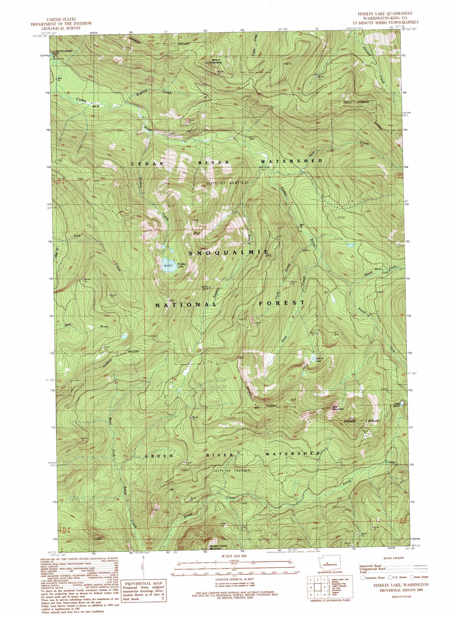
USGS Topo Quad 47121c5 - 1:24,000 scale
| Topo Map Name: | Findley Lake |
| USGS Topo Quad ID: | 47121c5 |
| Print Size: | ca. 21 1/4" wide x 27" high |
| Southeast Coordinates: | 47.25° N latitude / 121.5° W longitude |
| Map Center Coordinates: | 47.3125° N latitude / 121.5625° W longitude |
| U.S. State: | WA |
| Filename: | o47121c5.jpg |
| Download Map JPG Image: | Findley Lake topo map 1:24,000 scale |
| Map Type: | Topographic |
| Topo Series: | 7.5´ |
| Map Scale: | 1:24,000 |
| Source of Map Images: | United States Geological Survey (USGS) |
| Alternate Map Versions: |
Findley Lake WA 1989, updated 1989 Download PDF Buy paper map Findley Lake WA 2011 Download PDF Buy paper map Findley Lake WA 2014 Download PDF Buy paper map |
| FStopo: | US Forest Service topo Findley Lake is available: Download FStopo PDF Download FStopo TIF |
1:24,000 Topo Quads surrounding Findley Lake
Snoqualmie |
Mount Si |
Lake Philippa |
Snoqualmie Lake |
Big Snow Mountain |
North Bend |
Chester Morse Lake |
Bandera |
Snoqualmie Pass |
Chikamin Peak |
Eagle Gorge |
Cougar Mountain |
Findley Lake |
Lost Lake |
Stampede Pass |
Cyclone Creek |
Greenwater |
Nagrom |
Lester |
Blowout Mountain |
Bearhead Mountain |
Clear West Peak |
Sun Top |
Noble Knob |
Raven Roost |
> Back to 47121a1 at 1:100,000 scale
> Back to 47120a1 at 1:250,000 scale
> Back to U.S. Topo Maps home
Findley Lake topo map: Gazetteer
Findley Lake: Areas
Cedar River Watershed elevation 1049m 3441′Findley Lake: Lakes
Findley Lake elevation 1129m 3704′Lake Albert elevation 937m 3074′
Sutton Lake elevation 1106m 3628′
Findley Lake: Streams
Bear Creek elevation 577m 1893′Findley Creek elevation 519m 1702′
Goat Creek elevation 638m 2093′
North Fork Cedar River elevation 678m 2224′
Roaring Creek elevation 509m 1669′
Seattle Creek elevation 622m 2040′
South Fork Cedar River elevation 668m 2191′
Viola Creek elevation 624m 2047′
Findley Lake: Summits
Goat Mountain elevation 1416m 4645′Mount Gardner elevation 1345m 4412′
Findley Lake: Trails
Gardner Mountain Trail elevation 1375m 4511′Hansen Creek Trail elevation 999m 3277′
Findley Lake digital topo map on disk
Buy this Findley Lake topo map showing relief, roads, GPS coordinates and other geographical features, as a high-resolution digital map file on DVD: