The Cradle Topo Map Washington
To zoom in, hover over the map of The Cradle
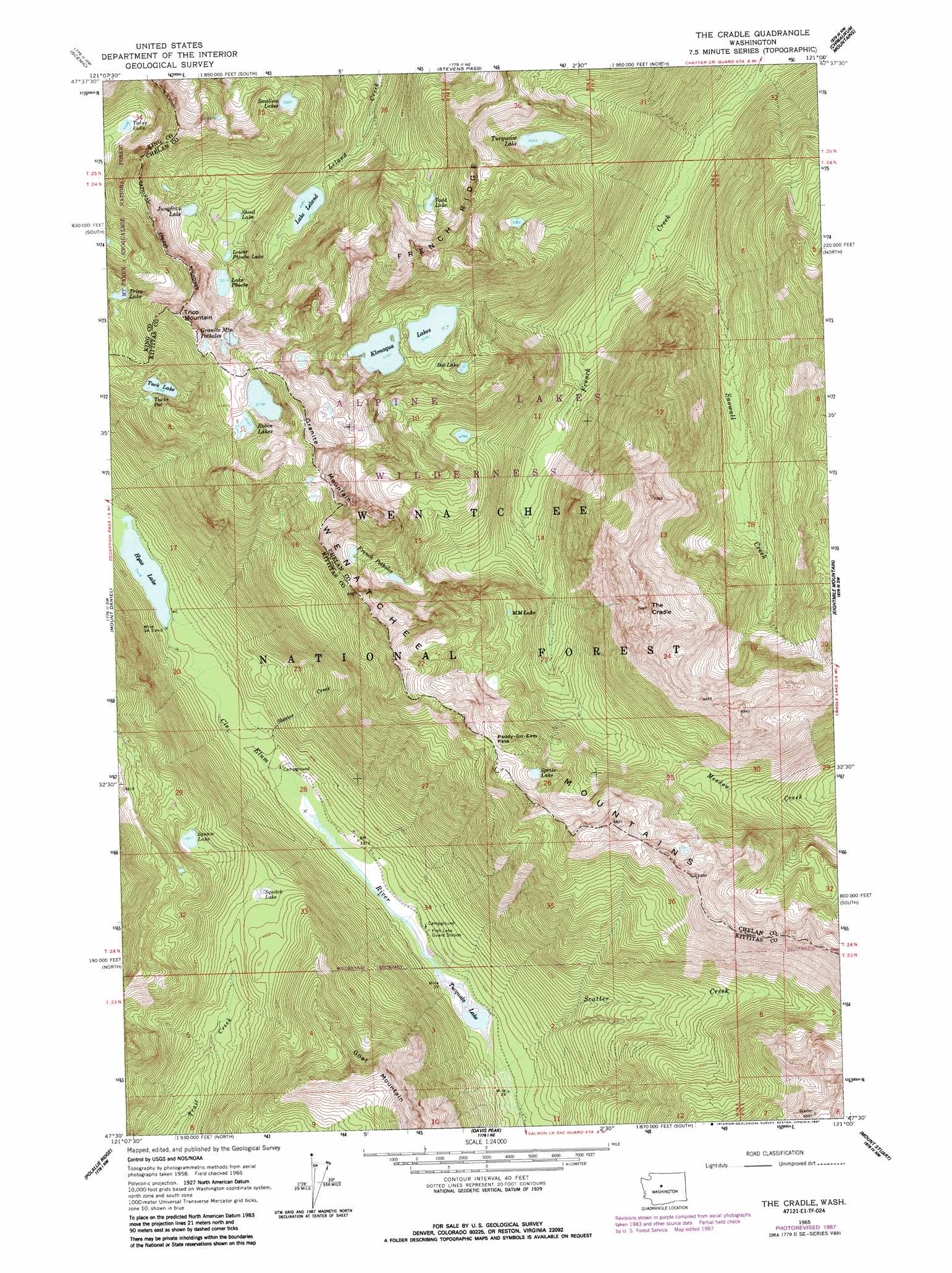
USGS Topo Quad 47121e1 - 1:24,000 scale
| Topo Map Name: | The Cradle |
| USGS Topo Quad ID: | 47121e1 |
| Print Size: | ca. 21 1/4" wide x 27" high |
| Southeast Coordinates: | 47.5° N latitude / 121° W longitude |
| Map Center Coordinates: | 47.5625° N latitude / 121.0625° W longitude |
| U.S. State: | WA |
| Filename: | o47121e1.jpg |
| Download Map JPG Image: | The Cradle topo map 1:24,000 scale |
| Map Type: | Topographic |
| Topo Series: | 7.5´ |
| Map Scale: | 1:24,000 |
| Source of Map Images: | United States Geological Survey (USGS) |
| Alternate Map Versions: |
The Cradle WA 1965, updated 1967 Download PDF Buy paper map The Cradle WA 1965, updated 1973 Download PDF Buy paper map The Cradle WA 1965, updated 1987 Download PDF Buy paper map The Cradle WA 2003, updated 2006 Download PDF Buy paper map The Cradle WA 2011 Download PDF Buy paper map The Cradle WA 2014 Download PDF Buy paper map |
| FStopo: | US Forest Service topo The Cradle is available: Download FStopo PDF Download FStopo TIF |
1:24,000 Topo Quads surrounding The Cradle
Evergreen Mountain |
Captain Point |
Labyrinth Mountain |
Mount Howard |
Lake Wenatchee |
Skykomish |
Scenic |
Stevens Pass |
Chiwaukum Mountains |
Big Jim Mountain |
Big Snow Mountain |
Mount Daniel |
The Cradle |
Jack Ridge |
Cashmere Mountain |
Chikamin Peak |
Polallie Ridge |
Davis Peak |
Mount Stuart |
Enchantment Lakes |
Stampede Pass |
Kachess Lake |
Cle Elum Lake |
Teanaway Butte |
Red Top Mountain |
> Back to 47121e1 at 1:100,000 scale
> Back to 47120a1 at 1:250,000 scale
> Back to U.S. Topo Maps home
The Cradle topo map: Gazetteer
The Cradle: Dams
Klonaqua Lake Dam elevation 1574m 5164′The Cradle: Forests
Cle Elum Ranger District elevation 1574m 5164′The Cradle: Gaps
Paddy-Go-Easy Pass elevation 1857m 6092′The Cradle: Lakes
Bobs Lake elevation 1590m 5216′Carrie Lake elevation 1581m 5187′
French Potholes elevation 1656m 5433′
Granite Mountain Potholes elevation 1837m 6026′
Hyas Lake elevation 1052m 3451′
Jungfrau Lake elevation 1631m 5351′
Lake Leland elevation 1361m 4465′
Lake Phoebe elevation 1591m 5219′
Lower Phoebe Lake elevation 1569m 5147′
M M Lake elevation 1571m 5154′
Robin Lakes elevation 1884m 6181′
Shoal Lake elevation 1568m 5144′
Sprite Lake elevation 1824m 5984′
Squaw Lake elevation 1485m 4872′
Squitch Lake elevation 1375m 4511′
Talus Lake elevation 1632m 5354′
Todd Lake elevation 1627m 5337′
Trico Lake elevation 1728m 5669′
Tuck Lake elevation 1607m 5272′
Tucks Pot elevation 1605m 5265′
Tucquala Lake elevation 1019m 3343′
Turquaise Lake elevation 1667m 5469′
Welcome Lake elevation 1643m 5390′
The Cradle: Reservoirs
Klonaqua Lakes elevation 1574m 5164′The Cradle: Streams
Scatter Creek elevation 1018m 3339′Skeeter Creek elevation 1027m 3369′
Snowall Creek elevation 1015m 3330′
The Cradle: Summits
Granite Mountain elevation 2147m 7043′The Cradle elevation 2204m 7230′
Trico Mountain elevation 2012m 6601′
The Cradle digital topo map on disk
Buy this The Cradle topo map showing relief, roads, GPS coordinates and other geographical features, as a high-resolution digital map file on DVD: