Picayune Topo Map Mississippi
To zoom in, hover over the map of Picayune
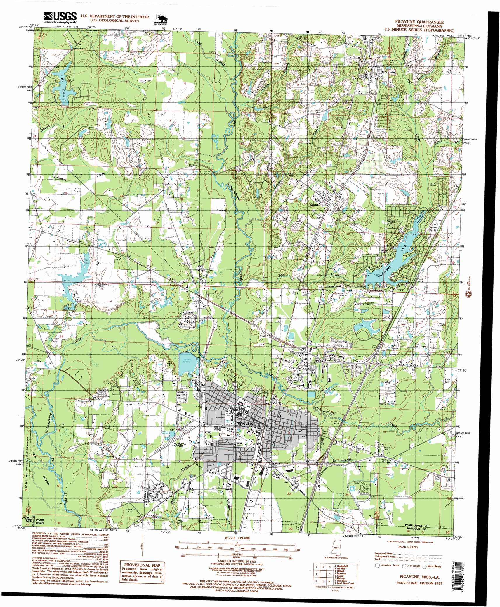
USGS Topo Quad 30089e6 - 1:24,000 scale
| Topo Map Name: | Picayune |
| USGS Topo Quad ID: | 30089e6 |
| Print Size: | ca. 21 1/4" wide x 27" high |
| Southeast Coordinates: | 30.5° N latitude / 89.625° W longitude |
| Map Center Coordinates: | 30.5625° N latitude / 89.6875° W longitude |
| U.S. States: | MS, LA |
| Filename: | o30089e6.jpg |
| Download Map JPG Image: | Picayune topo map 1:24,000 scale |
| Map Type: | Topographic |
| Topo Series: | 7.5´ |
| Map Scale: | 1:24,000 |
| Source of Map Images: | United States Geological Survey (USGS) |
| Alternate Map Versions: |
Picayune MS 1985, updated 1985 Download PDF Buy paper map Picayune MS 1985, updated 1985 Download PDF Buy paper map Picayune MS 1997, updated 1999 Download PDF Buy paper map Picayune MS 2012 Download PDF Buy paper map Picayune MS 2015 Download PDF Buy paper map |
1:24,000 Topo Quads surrounding Picayune
Bogalusa West |
Bogalusa East |
White Sand |
Poplarville |
Big Swamp |
Sun |
Henleyfield |
Mcneill |
Millard |
Savannah |
Bush |
Industrial |
Picayune |
Caesar |
Necaise |
Saint Tammany |
Hickory |
Nicholson |
Dead Tiger Creek |
Kiln |
Lacombe |
Slidell |
Haaswood |
Logtown |
Waveland |
> Back to 30089e1 at 1:100,000 scale
> Back to 30088a1 at 1:250,000 scale
> Back to U.S. Topo Maps home
Picayune topo map: Gazetteer
Picayune: Airports
Picayune Municipal Airport elevation 18m 59′Picayune: Crossings
Interchange 4 elevation 18m 59′Interchange 6 elevation 19m 62′
Picayune: Dams
Crosby Chemical Company Lagoon Dam elevation 19m 62′David Lake Dam elevation 21m 68′
Double C Ranch Lake Dam elevation 14m 45′
Earl Pinham Lake Dam elevation 47m 154′
Hide-A-Way Lake Dam elevation 23m 75′
Neil Lumpkin Lake Dam elevation 35m 114′
Picayune: Guts
Farr Slough elevation 8m 26′Picayune: Parks
Friendship Park elevation 20m 65′Picayune: Populated Places
Carriere elevation 48m 157′Ozona elevation 39m 127′
Palestine elevation 14m 45′
Picayune elevation 22m 72′
Richardson elevation 22m 72′
Picayune: Post Offices
Picayune Post Office elevation 22m 72′Picayune: Reservoirs
Lake David elevation 30m 98′Lake Hide-A-Way elevation 23m 75′
Picayune: Streams
Bay Branch elevation 15m 49′Dutch Branch elevation 27m 88′
East Hobolochitto Creek elevation 11m 36′
George Branch elevation 16m 52′
Long Branch elevation 19m 62′
Lutens Branch elevation 29m 95′
Marsen Branch elevation 13m 42′
Mill Creek elevation 14m 45′
Rattlesnake Bay elevation 34m 111′
West Hobolochitto Creek elevation 11m 36′
Picayune digital topo map on disk
Buy this Picayune topo map showing relief, roads, GPS coordinates and other geographical features, as a high-resolution digital map file on DVD:
Gulf Coast (LA, MS, AL, FL) & Southwestern Georgia
Buy digital topo maps: Gulf Coast (LA, MS, AL, FL) & Southwestern Georgia
 & Southwestern Georgia map DVD")