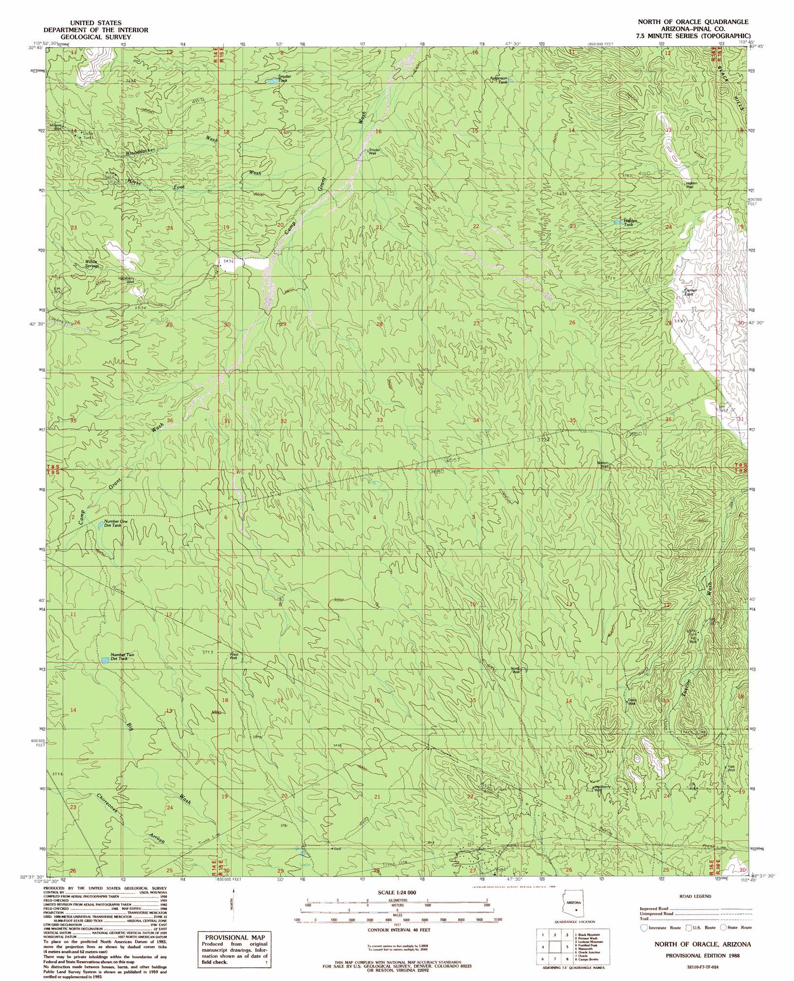
North Of Oracle Topo Map Arizona
To zoom in, hover over the map of North Of Oracle
USGS Topo Quad 32110f7 - 1:24,000 scale
| Topo Map Name: | North Of Oracle |
| USGS Topo Quad ID: | 32110f7 |
| Print Size: | ca. 21 1/4" wide x 27" high |
| Southeast Coordinates: | 32.625° N latitude / 110.75° W longitude |
| Map Center Coordinates: | 32.6875° N latitude / 110.8125° W longitude |
| U.S. State: | AZ |
| Filename: | o32110f7.jpg |
| Download Map JPG Image: | North Of Oracle topo map 1:24,000 scale |
| Map Type: | Topographic |
| Topo Series: | 7.5´ |
| Map Scale: | 1:24,000 |
| Source of Map Images: | United States Geological Survey (USGS) |
| Alternate Map Versions: |
North of Oracle AZ 1988, updated 1989 Download PDF Buy paper map North of Oracle AZ 1996, updated 2003 Download PDF Buy paper map North of Oracle AZ 2011 Download PDF Buy paper map North of Oracle AZ 2014 Download PDF Buy paper map |
1:24,000 Topo Quads surrounding North Of Oracle
Ninetysix Hills Ne |
Crozier Peak |
Winkelman |
Dudleyville |
Brandenburg Mountain |
Ninetysix Hills Se |
Black Mountain |
Putnam Wash |
Lookout Mountain |
Holy Joe Peak |
Chief Butte |
Fortified Peak |
North Of Oracle |
Mammoth |
Clark Ranch |
Tortolita Mountains |
Oracle Junction |
Oracle |
Campo Bonito |
Peppersauce Wash |
Ruelas Canyon |
Oro Valley |
Mount Lemmon |
Mount Bigelow |
Buehman Canyon |
> Back to 32110e1 at 1:100,000 scale
> Back to 32110a1 at 1:250,000 scale
> Back to U.S. Topo Maps home
North Of Oracle topo map: Gazetteer
North Of Oracle: Reservoirs
Anderson Tank elevation 1050m 3444′Corner Tank elevation 1156m 3792′
Hidden Tank elevation 1147m 3763′
Number One Dirt Tank elevation 1094m 3589′
Number Two Dirt Tank elevation 1140m 3740′
Snyder Tank elevation 1040m 3412′
North Of Oracle: Springs
Willow Springs elevation 1094m 3589′North Of Oracle: Streams
Bloodsucker Wash elevation 1019m 3343′Horse Foot Wash elevation 995m 3264′
North Of Oracle: Wells
Deep Well elevation 1229m 4032′Fitz Well elevation 1192m 3910′
Hackberry Well elevation 1281m 4202′
Hackberry Well elevation 1072m 3517′
Hidden Well elevation 1194m 3917′
Nelson Well elevation 1160m 3805′
North Well elevation 1220m 4002′
Sargent Well elevation 1120m 3674′
Snyder Well elevation 998m 3274′
West Well elevation 1149m 3769′
Yale Well elevation 1262m 4140′
North Of Oracle digital topo map on disk
Buy this North Of Oracle topo map showing relief, roads, GPS coordinates and other geographical features, as a high-resolution digital map file on DVD: