Sumter West Topo Map South Carolina
To zoom in, hover over the map of Sumter West
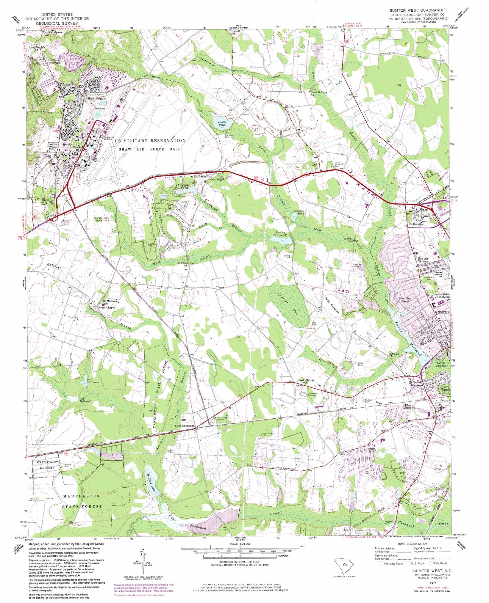
USGS Topo Quad 33080h4 - 1:24,000 scale
| Topo Map Name: | Sumter West |
| USGS Topo Quad ID: | 33080h4 |
| Print Size: | ca. 21 1/4" wide x 27" high |
| Southeast Coordinates: | 33.875° N latitude / 80.375° W longitude |
| Map Center Coordinates: | 33.9375° N latitude / 80.4375° W longitude |
| U.S. State: | SC |
| Filename: | o33080h4.jpg |
| Download Map JPG Image: | Sumter West topo map 1:24,000 scale |
| Map Type: | Topographic |
| Topo Series: | 7.5´ |
| Map Scale: | 1:24,000 |
| Source of Map Images: | United States Geological Survey (USGS) |
| Alternate Map Versions: |
Sumter West SC 1957, updated 1958 Download PDF Buy paper map Sumter West SC 1957, updated 1977 Download PDF Buy paper map Sumter West SC 1957, updated 1983 Download PDF Buy paper map Sumter West SC 1961, updated 1981 Download PDF Buy paper map Sumter West SC 2011 Download PDF Buy paper map Sumter West SC 2014 Download PDF Buy paper map |
1:24,000 Topo Quads surrounding Sumter West
Lugoff |
Camden South |
Spring Hill |
Bishopville West |
Bishopville East |
Leesburg |
Rembert |
Dalzell |
Oswego |
Elliott |
Eastover |
Wedgefield |
Sumter West |
Sumter East |
Mayesville |
Wateree |
Poinsett State Park |
Privateer |
Brogdon |
Tearcoat Branch |
Fort Motte |
Lone Star |
Pinewood |
Paxville |
Manning |
> Back to 33080e1 at 1:100,000 scale
> Back to 33080a1 at 1:250,000 scale
> Back to U.S. Topo Maps home
Sumter West topo map: Gazetteer
Sumter West: Airports
Creech Aviation Facility Airport elevation 64m 209′Sumter West: Basins
Green Bay elevation 57m 187′Pitts Savanna elevation 54m 177′
Sumter West: Dams
Booths Pond Dam D-1985 elevation 59m 193′Boyle Pond Dam D-1583 elevation 43m 141′
Burns Pond Dam D-2056 elevation 48m 157′
Lake Cherryvale Dam D-1986 elevation 58m 190′
Loring Millpond Dam D-1452 elevation 50m 164′
Lower Deerwood Lake Dam D-2078 elevation 46m 150′
Mathis Pond Dam D-2057 elevation 45m 147′
McCray Lake Dam D-1584 elevation 47m 154′
Montagues Pond Dam D-2055 elevation 51m 167′
Sawmill Pond Dam D-1987 elevation 50m 164′
Second Millpond Dam D-1444 elevation 42m 137′
Upper Deerwood Lake Dam elevation 51m 167′
West Lake Dam D-2054 elevation 47m 154′
Sumter West: Parks
Green Park elevation 52m 170′Memorial Stadium elevation 47m 154′
Palmetto Park elevation 55m 180′
Sumter West: Populated Places
Ashley Creek Village elevation 41m 134′Audubon Park elevation 53m 173′
Austin Acres elevation 55m 180′
Avondale elevation 52m 170′
Azalea Trailer Park elevation 55m 180′
Bay Springs elevation 55m 180′
Beckridge Park elevation 53m 173′
Beckwood elevation 55m 180′
Bon Air Terrace elevation 57m 187′
Bradford elevation 53m 173′
Cane Savannah elevation 55m 180′
Carolina Mobile Home Park elevation 87m 285′
Cartley Subdivision elevation 55m 180′
Causeway Branch elevation 51m 167′
Cherryvale elevation 64m 209′
Curtis Park elevation 53m 173′
Deerfield elevation 51m 167′
Dinkins elevation 55m 180′
East Sunway Knolls elevation 55m 180′
Edgewater elevation 48m 157′
General Sumter Estates elevation 90m 295′
Hearthstone elevation 54m 177′
Hilldale elevation 55m 180′
Home Acres elevation 103m 337′
Idlewood elevation 54m 177′
Marden Ranchettes elevation 98m 321′
Millwood elevation 52m 170′
Millwood Gardens elevation 52m 170′
North Deerfield elevation 51m 167′
Oak Haven Acres elevation 55m 180′
Oakland elevation 103m 337′
Park West elevation 50m 164′
Pinckney Crossroad elevation 106m 347′
Rainbow Falls elevation 55m 180′
Sanders Subdivision elevation 55m 180′
Sellars Heights elevation 55m 180′
Shady Grove elevation 52m 170′
Shaw Heights elevation 107m 351′
Spring Lake elevation 47m 154′
Summer View elevation 55m 180′
Sunset Homes elevation 56m 183′
Sunway Knolls elevation 57m 187′
Swinton elevation 58m 190′
The Village Subdivision elevation 55m 180′
Twin Lakes elevation 56m 183′
Warwick Estates elevation 46m 150′
Wedgewood Grove elevation 56m 183′
West Ridge elevation 56m 183′
Westhaven elevation 51m 167′
Windsor City Mobile Home Park elevation 52m 170′
Winter Park elevation 51m 167′
Sumter West: Reservoirs
Booths Pond elevation 59m 193′Boyle Pond elevation 43m 141′
Burns Pond elevation 48m 157′
Frierson Pond elevation 58m 190′
Lake Cherryvale elevation 58m 190′
Loring Millpond elevation 50m 164′
Lower Deerwood Lake elevation 46m 150′
Mathis Pond elevation 45m 147′
McCray Lake elevation 47m 154′
McCrays Lake elevation 47m 154′
Montagues Pond elevation 51m 167′
New Millpond elevation 55m 180′
Revilles Pond elevation 45m 147′
Sawmill Pond elevation 50m 164′
Second Millpond elevation 42m 137′
Shaw Golf Course Pond Number 1 elevation 83m 272′
Upper Deerwood Lake elevation 51m 167′
West Lake elevation 47m 154′
Sumter West: Streams
Bluffhead Branch elevation 47m 154′Brunson Swamp elevation 44m 144′
Hatchet Camp Branch elevation 47m 154′
Horsepen Branch elevation 54m 177′
Long Branch elevation 47m 154′
Mush Swamp elevation 45m 147′
Nasty Branch elevation 37m 121′
Spann Branch elevation 72m 236′
Suicide Branch elevation 50m 164′
Sumter West: Swamps
Cypress Bay elevation 55m 180′Old Millpond elevation 54m 177′
Sumter West digital topo map on disk
Buy this Sumter West topo map showing relief, roads, GPS coordinates and other geographical features, as a high-resolution digital map file on DVD:
South Carolina, Western North Carolina & Northeastern Georgia
Buy digital topo maps: South Carolina, Western North Carolina & Northeastern Georgia