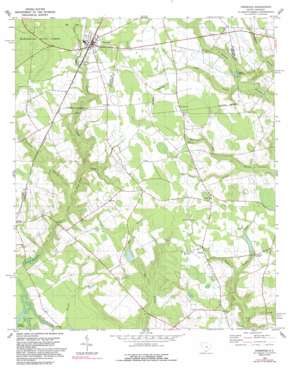
Pinewood Topo Map South Carolina
To zoom in, hover over the map of Pinewood
USGS Topo Quad 33080f4 - 1:24,000 scale
| Topo Map Name: | Pinewood |
| USGS Topo Quad ID: | 33080f4 |
| Print Size: | ca. 21 1/4" wide x 27" high |
| Southeast Coordinates: | 33.625° N latitude / 80.375° W longitude |
| Map Center Coordinates: | 33.6875° N latitude / 80.4375° W longitude |
| U.S. State: | SC |
| Filename: | o33080f4.jpg |
| Download Map JPG Image: | Pinewood topo map 1:24,000 scale |
| Map Type: | Topographic |
| Topo Series: | 7.5´ |
| Map Scale: | 1:24,000 |
| Source of Map Images: | United States Geological Survey (USGS) |
| Alternate Map Versions: |
Pinewood SC 1980, updated 1980 Download PDF Buy paper map Pinewood SC 1980, updated 1992 Download PDF Buy paper map Pinewood SC 2011 Download PDF Buy paper map Pinewood SC 2014 Download PDF Buy paper map |
1:24,000 Topo Quads surrounding Pinewood
> Back to 33080e1 at 1:100,000 scale
> Back to 33080a1 at 1:250,000 scale
> Back to U.S. Topo Maps home
Pinewood topo map: Gazetteer
Pinewood: Dams
George Tindal Pond Dam D-3496 elevation 37m 121′South Carolina Noname 14002 D-3498 Dam elevation 42m 137′
South Carolina Noname 14003 D-3497 Dam elevation 43m 141′
South Carolina Noname 14008 D-3495 Dam elevation 27m 88′
Pinewood: Populated Places
Hodges Corner elevation 54m 177′Panola elevation 47m 154′
Pinewood elevation 58m 190′
Pinewood: Post Offices
Pinewood Post Office elevation 58m 190′Pinewood: Reservoirs
Curtis Millpond elevation 44m 144′Elliot Pond elevation 27m 88′
Elliott Millpond elevation 26m 85′
Fox Tindal Pond elevation 43m 141′
G Tindal Pond elevation 37m 121′
Sigmon Pond elevation 42m 137′
Pinewood: Streams
Ballard Creek elevation 37m 121′Belser Creek elevation 30m 98′
Chapel Creek elevation 37m 121′
Des Champs Branch elevation 41m 134′
Duckford Branch elevation 34m 111′
Half Way Creek elevation 34m 111′
Pine Tree Creek elevation 51m 167′
Richardson Branch elevation 25m 82′
Taylor Branch elevation 33m 108′
Pinewood digital topo map on disk
Buy this Pinewood topo map showing relief, roads, GPS coordinates and other geographical features, as a high-resolution digital map file on DVD:
South Carolina, Western North Carolina & Northeastern Georgia
Buy digital topo maps: South Carolina, Western North Carolina & Northeastern Georgia


