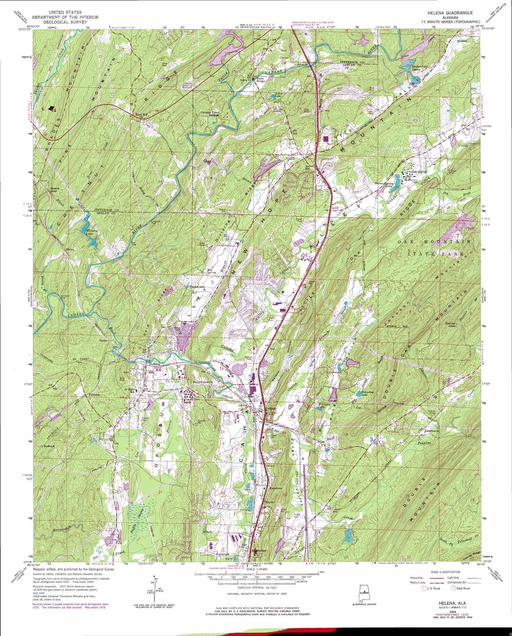
Helena Topo Map Alabama
To zoom in, hover over the map of Helena
USGS Topo Quad 33086c7 - 1:24,000 scale
| Topo Map Name: | Helena |
| USGS Topo Quad ID: | 33086c7 |
| Print Size: | ca. 21 1/4" wide x 27" high |
| Southeast Coordinates: | 33.25° N latitude / 86.75° W longitude |
| Map Center Coordinates: | 33.3125° N latitude / 86.8125° W longitude |
| U.S. State: | AL |
| Filename: | o33086c7.jpg |
| Download Map JPG Image: | Helena topo map 1:24,000 scale |
| Map Type: | Topographic |
| Topo Series: | 7.5´ |
| Map Scale: | 1:24,000 |
| Source of Map Images: | United States Geological Survey (USGS) |
| Alternate Map Versions: |
Helena AL 1959, updated 1960 Download PDF Buy paper map Helena AL 1959, updated 1964 Download PDF Buy paper map Helena AL 1959, updated 1971 Download PDF Buy paper map Helena AL 1959, updated 1978 Download PDF Buy paper map Helena AL 1959, updated 1986 Download PDF Buy paper map Helena AL 1959, updated 1991 Download PDF Buy paper map Helena AL 1975, updated 1977 Download PDF Buy paper map Helena AL 1997, updated 2001 Download PDF Buy paper map Helena AL 2011 Download PDF Buy paper map Helena AL 2014 Download PDF Buy paper map |
1:24,000 Topo Quads surrounding Helena
Sylvan Springs |
Adamsville |
Birmingham North |
Irondale |
Leeds |
Concord |
Bessemer |
Birmingham South |
Cahaba Heights |
Vandiver |
Mccalla |
Greenwood |
Helena |
Chelsea |
Westover |
Halfmile Shoals |
Pea Ridge |
Alabaster |
Bounds Lake |
Columbiana |
West Blocton East |
Aldrich |
Montevallo |
Ozan |
Shelby |
> Back to 33086a1 at 1:100,000 scale
> Back to 33086a1 at 1:250,000 scale
> Back to U.S. Topo Maps home
Helena topo map: Gazetteer
Helena: Bridges
Bains Bridge elevation 120m 393′Cobb Bridge elevation 120m 393′
Helena: Crossings
Greenlee Ford elevation 128m 419′Interchange 242 elevation 144m 472′
Interchange 246 elevation 142m 465′
Interchange 247 elevation 146m 479′
Langston Ford elevation 125m 410′
Nunnally Ford elevation 118m 387′
Roy Ford elevation 114m 374′
Helena: Dams
Caddell Lake Dam elevation 145m 475′Dobbin Brothers Dam elevation 149m 488′
Huckaby Lake Dam elevation 149m 488′
Lake Melaken Dam elevation 165m 541′
Oak Mountain New Lake Dam elevation 149m 488′
Patton Creek Dam elevation 119m 390′
Rutherford Dam elevation 150m 492′
Rutherford Lake Dam Number 1 elevation 130m 426′
Rutherford Lake Dam Number 2 elevation 169m 554′
Tulleys Real Estate Lake Dam elevation 120m 393′
Wilborn Lake Dam elevation 127m 416′
Wyatt Lake Dam elevation 158m 518′
Helena: Falls
Peavine Falls elevation 257m 843′Helena: Gaps
Brock Gap elevation 158m 518′Helena: Lakes
Acton Lake elevation 157m 515′Wilborn Lake elevation 119m 390′
Helena: Mines
Acton Mine elevation 160m 524′Booth Mine elevation 147m 482′
Dickey Mine elevation 137m 449′
Elvira Mine elevation 141m 462′
Gould Mines elevation 126m 413′
Helena Quarry elevation 134m 439′
Moore Mine elevation 136m 446′
Moyle Mine elevation 138m 452′
Murphy Mine elevation 142m 465′
Paramount Mine elevation 134m 439′
Parkwood Mine elevation 173m 567′
Roebuck Mine elevation 184m 603′
Smith Mine elevation 156m 511′
Helena: Parks
Hoover Metropolitan Stadium elevation 147m 482′Hoover Sports Park West elevation 207m 679′
Joe Tucker Park elevation 135m 442′
Ned Bearden Stadium elevation 195m 639′
Riverchase Sports Park elevation 127m 416′
Helena: Populated Places
Acton elevation 154m 505′Blueberry Estates elevation 154m 505′
Cahaba River Estates elevation 137m 449′
Cahaba Valley Estates elevation 150m 492′
Calliston elevation 146m 479′
Chandalar South elevation 152m 498′
Dearing Downs elevation 151m 495′
Deer Springs Estates elevation 167m 547′
Deerhurst elevation 159m 521′
Dunaway Farms elevation 146m 479′
Elvira elevation 147m 482′
Falliston elevation 140m 459′
Fox Haven elevation 161m 528′
Fungo Hollow elevation 164m 538′
Hardy elevation 145m 475′
Helena elevation 127m 416′
Hunters Glen (historical) elevation 188m 616′
Indian Hills elevation 160m 524′
Indian Lake Estates elevation 185m 606′
Indian Springs Ranch elevation 150m 492′
Indian Springs Village elevation 155m 508′
Keystone elevation 145m 475′
Kingwood elevation 153m 501′
Little Oak Ridge Estates elevation 167m 547′
Mallard Point elevation 163m 534′
Mars Hill elevation 146m 479′
Navajo Hills elevation 187m 613′
Navajo Pines elevation 141m 462′
Paramount elevation 145m 475′
Pelham elevation 153m 501′
Port South elevation 193m 633′
Quail Run elevation 146m 479′
Roebuck elevation 140m 459′
Rolling Ridge elevation 213m 698′
Royal Oaks elevation 159m 521′
Scottrock elevation 148m 485′
Shades Acres elevation 201m 659′
Shady Acres Estates elevation 246m 807′
Shannon Glen elevation 138m 452′
Southlake elevation 163m 534′
Tacoa elevation 129m 423′
Timbercrest elevation 214m 702′
Valdawood elevation 176m 577′
Valley Forge elevation 158m 518′
Valley Station elevation 152m 498′
Wooddale elevation 204m 669′
Helena: Post Offices
Helena Post Office elevation 137m 449′Helena: Reservoirs
Caddell Lake elevation 145m 475′Dobbin Brothers Lake elevation 149m 488′
Double Oak Lake elevation 149m 488′
Holtzclaw Lake elevation 156m 511′
Indian Estates Lake elevation 149m 488′
Indian Spring Lake elevation 141m 462′
Indian Valley Lake elevation 120m 393′
Lake Melaken elevation 165m 541′
Paradise Lake elevation 121m 396′
Rutherford Lake elevation 150m 492′
Rutherford Lake Number One elevation 130m 426′
Rutherford Lake Number Two elevation 169m 554′
Rutherford Lakes elevation 128m 419′
Williams Lake elevation 153m 501′
Wyatt Lake elevation 158m 518′
Helena: Ridges
Dividing Ridge elevation 156m 511′Gold Ridge elevation 180m 590′
Helena: Springs
Highland Spring elevation 147m 482′Lee Spring elevation 133m 436′
Roy Spring elevation 149m 488′
Helena: Streams
Acton Creek elevation 120m 393′Bailey Brook elevation 117m 383′
Bailey Brook elevation 116m 380′
Big Sucker Brook elevation 144m 472′
Black Creek elevation 114m 374′
Buck Creek elevation 113m 370′
Cahaba Valley Creek elevation 125m 410′
Coales Branch elevation 133m 436′
Dodd Branch elevation 119m 390′
Dry Brook elevation 142m 465′
Dry Creek elevation 126m 413′
Hogpen Creek elevation 134m 439′
Johnson Branch elevation 140m 459′
Johnson Brook elevation 153m 501′
Lacey Branch elevation 128m 419′
Lee Branch elevation 151m 495′
Lee Brook elevation 127m 416′
Martin Brook elevation 115m 377′
Patton Creek elevation 121m 396′
Peavine Creek elevation 131m 429′
Prairie Brook elevation 125m 410′
Scout Creek elevation 123m 403′
Helena: Summits
Johnson Mountain elevation 240m 787′Helena: Swamps
Ruffin Swamp elevation 132m 433′Helena: Valleys
Fungo Hollow elevation 139m 456′Fungo Valley elevation 131m 429′
Little Valley elevation 124m 406′
Nelson Hollow elevation 139m 456′
Helena digital topo map on disk
Buy this Helena topo map showing relief, roads, GPS coordinates and other geographical features, as a high-resolution digital map file on DVD: