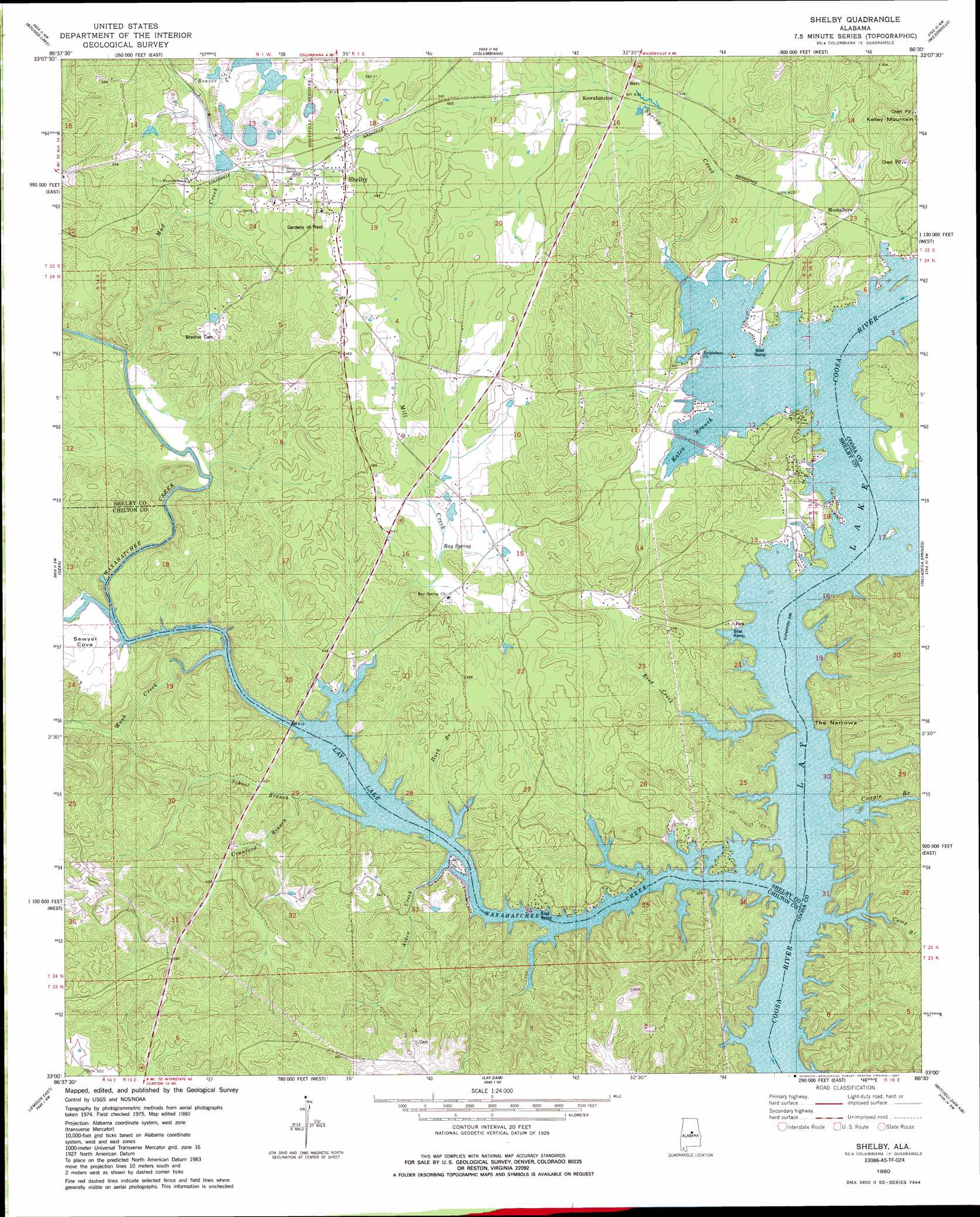
Shelby Topo Map Alabama
To zoom in, hover over the map of Shelby
USGS Topo Quad 33086a5 - 1:24,000 scale
| Topo Map Name: | Shelby |
| USGS Topo Quad ID: | 33086a5 |
| Print Size: | ca. 21 1/4" wide x 27" high |
| Southeast Coordinates: | 33° N latitude / 86.5° W longitude |
| Map Center Coordinates: | 33.0625° N latitude / 86.5625° W longitude |
| U.S. State: | AL |
| Filename: | o33086a5.jpg |
| Download Map JPG Image: | Shelby topo map 1:24,000 scale |
| Map Type: | Topographic |
| Topo Series: | 7.5´ |
| Map Scale: | 1:24,000 |
| Source of Map Images: | United States Geological Survey (USGS) |
| Alternate Map Versions: |
Columbiana SE AL 1975, updated 1977 Download PDF Buy paper map Shelby AL 1980, updated 1980 Download PDF Buy paper map Shelby AL 1980, updated 1987 Download PDF Buy paper map Shelby AL 2011 Download PDF Buy paper map Shelby AL 2014 Download PDF Buy paper map |
1:24,000 Topo Quads surrounding Shelby
Helena |
Chelsea |
Westover |
Harpersville |
Childersburg |
Alabaster |
Bounds Lake |
Columbiana |
Wilsonville |
Sylacauga West |
Montevallo |
Ozan |
Shelby |
Talladega Springs |
Weogufka |
Jemison West |
Jemison East |
Lay Dam |
Mitchell Dam Nw |
Flag Mountain |
Maplesville East |
Clanton West |
Clanton East |
Mitchell Dam |
Richville |
> Back to 33086a1 at 1:100,000 scale
> Back to 33086a1 at 1:250,000 scale
> Back to U.S. Topo Maps home
Shelby topo map: Gazetteer
Shelby: Basins
Sawyer Cove elevation 133m 436′Shelby: Capes
Turtle Point elevation 119m 390′Shelby: Crossings
Watson Ford elevation 119m 390′Shelby: Gaps
The Narrows elevation 119m 390′Shelby: Populated Places
Aucheucaula (historical) elevation 151m 495′Dogwood Point elevation 126m 413′
Kewahatchie elevation 131m 429′
Merrell Beach elevation 127m 416′
Mostellers elevation 131m 429′
Pine Grove Village elevation 133m 436′
Shelby elevation 151m 495′
Spring Creek elevation 124m 406′
Wildwood Shores elevation 146m 479′
Shelby: Post Offices
Shelby Post Office elevation 157m 515′Spring Grove Post Office (historical) elevation 129m 423′
Shelby: Springs
Bay Spring elevation 133m 436′Kewahatchie Spring elevation 129m 423′
Shelby: Streams
Aiken Creek elevation 124m 406′Beaver Creek elevation 145m 475′
Buxahatchee Creek elevation 119m 390′
Camp Branch elevation 119m 390′
Coagie Branch elevation 119m 390′
Crawford Branch elevation 119m 390′
Duck Branch elevation 119m 390′
Kates Branch elevation 119m 390′
Mill Creek elevation 119m 390′
Mud Creek elevation 122m 400′
Reed Creek elevation 119m 390′
School Branch elevation 121m 396′
Spring Creek elevation 119m 390′
Wash Creek elevation 119m 390′
Waxahatchee Creek elevation 119m 390′
Shelby digital topo map on disk
Buy this Shelby topo map showing relief, roads, GPS coordinates and other geographical features, as a high-resolution digital map file on DVD: