Carbon Springs Topo Map New Mexico
To zoom in, hover over the map of Carbon Springs
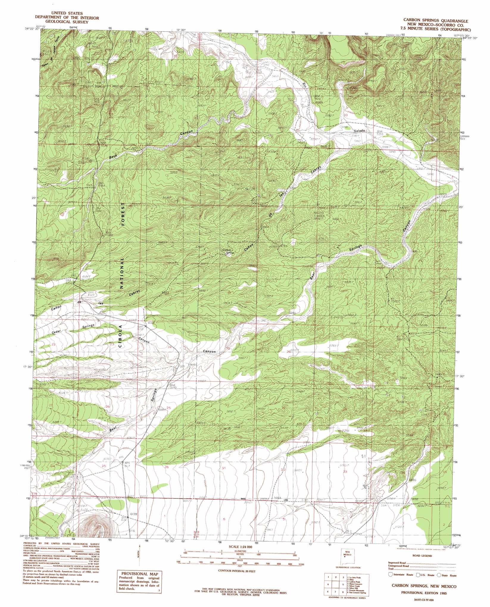
USGS Topo Quad 34107c2 - 1:24,000 scale
| Topo Map Name: | Carbon Springs |
| USGS Topo Quad ID: | 34107c2 |
| Print Size: | ca. 21 1/4" wide x 27" high |
| Southeast Coordinates: | 34.25° N latitude / 107.125° W longitude |
| Map Center Coordinates: | 34.3125° N latitude / 107.1875° W longitude |
| U.S. State: | NM |
| Filename: | o34107c2.jpg |
| Download Map JPG Image: | Carbon Springs topo map 1:24,000 scale |
| Map Type: | Topographic |
| Topo Series: | 7.5´ |
| Map Scale: | 1:24,000 |
| Source of Map Images: | United States Geological Survey (USGS) |
| Alternate Map Versions: |
Carbon Springs NM 1985, updated 1985 Download PDF Buy paper map Carbon Springs NM 1995, updated 1998 Download PDF Buy paper map Carbon Springs NM 2011 Download PDF Buy paper map Carbon Springs NM 2013 Download PDF Buy paper map Carbon Springs NM 2017 Download PDF Buy paper map |
| FStopo: | US Forest Service topo Carbon Springs is available: Download FStopo PDF Download FStopo TIF |
1:24,000 Topo Quads surrounding Carbon Springs
Field Ranch |
Puerto De Los Cavadores |
Mesa Sarca |
Comanche Ranch |
Belen Sw |
Puertecito |
La Jara Peak |
Riley |
Ladron Peak |
La Joya Nw |
Indian Spring Canyon |
Mesa Cencerro |
Carbon Springs |
Silver Creek |
San Acacia |
Gallinas Peak |
Silver Hill |
Granite Mountain |
San Lorenzo Spring |
Lemitar |
Tres Montosas |
Arroyo Landavaso |
Magdalena |
Water Canyon |
Socorro |
> Back to 34107a1 at 1:100,000 scale
> Back to 34106a1 at 1:250,000 scale
> Back to U.S. Topo Maps home
Carbon Springs topo map: Gazetteer
Carbon Springs: Reservoirs
Boulder Tank elevation 1864m 6115′Carbon Springs: Springs
Baca Spring elevation 1727m 5666′Carbon Springs elevation 1743m 5718′
Carbon Springs: Valleys
Baca Canyon elevation 1648m 5406′Bear Springs Canyon elevation 1615m 5298′
Cañon de las Cabras elevation 1632m 5354′
Cedar Springs Canyon elevation 1791m 5875′
Carbon Springs: Wells
10031 Water Well elevation 1822m 5977′Carbon Springs digital topo map on disk
Buy this Carbon Springs topo map showing relief, roads, GPS coordinates and other geographical features, as a high-resolution digital map file on DVD: