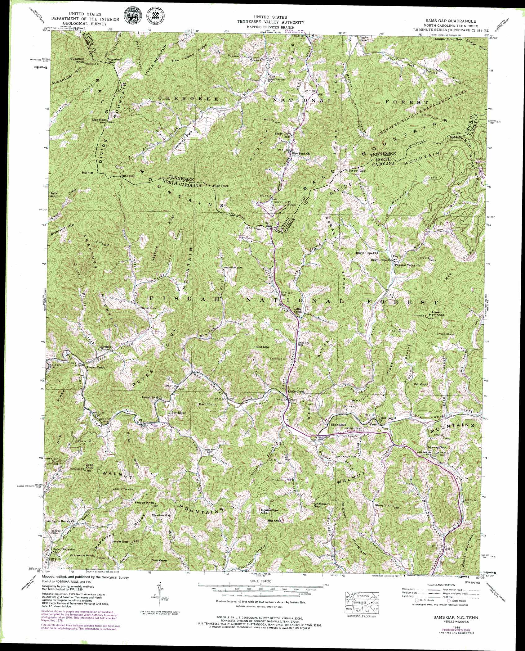
Sams Gap Topo Map North Carolina
To zoom in, hover over the map of Sams Gap
USGS Topo Quad 35082h5 - 1:24,000 scale
| Topo Map Name: | Sams Gap |
| USGS Topo Quad ID: | 35082h5 |
| Print Size: | ca. 21 1/4" wide x 27" high |
| Southeast Coordinates: | 35.875° N latitude / 82.5° W longitude |
| Map Center Coordinates: | 35.9375° N latitude / 82.5625° W longitude |
| U.S. States: | NC, TN |
| Filename: | o35082h5.jpg |
| Download Map JPG Image: | Sams Gap topo map 1:24,000 scale |
| Map Type: | Topographic |
| Topo Series: | 7.5´ |
| Map Scale: | 1:24,000 |
| Source of Map Images: | United States Geological Survey (USGS) |
| Alternate Map Versions: |
Sams Gap NC 1936 Download PDF Buy paper map Sams Gap NC 1939, updated 1960 Download PDF Buy paper map Sams Gap NC 1939, updated 1967 Download PDF Buy paper map Sams Gap NC 1939, updated 1975 Download PDF Buy paper map Sams Gap NC 1939, updated 1978 Download PDF Buy paper map Sams Gap NC 1939, updated 1978 Download PDF Buy paper map Sams Gap NC 1940 Download PDF Buy paper map Sams Gap NC 2011 Download PDF Buy paper map Sams Gap NC 2013 Download PDF Buy paper map Sams Gap NC 2016 Download PDF Buy paper map |
| FStopo: | US Forest Service topo Sams Gap is available: Download FStopo PDF Download FStopo TIF |
1:24,000 Topo Quads surrounding Sams Gap
Greeneville |
Chuckey |
Telford |
Erwin |
Unicoi |
Davy Crockett Lake |
Greystone |
Flag Pond |
Chestoa |
Huntdale |
Hot Springs |
White Rock |
Sams Gap |
Bald Creek |
Burnsville |
Spring Creek |
Marshall |
Mars Hill |
Barnardsville |
Mount Mitchell |
Sandymush |
Leicester |
Weaverville |
Craggy Pinnacle |
Montreat |
> Back to 35082e1 at 1:100,000 scale
> Back to 35082a1 at 1:250,000 scale
> Back to U.S. Topo Maps home
Sams Gap topo map: Gazetteer
Sams Gap: Flats
Big Flat elevation 1247m 4091′Jackson Flats elevation 862m 2828′
Jackson Flats elevation 876m 2874′
Sams Gap: Gaps
Bearwallow Gap elevation 1149m 3769′Hack Gap elevation 1192m 3910′
Jessie Gap elevation 923m 3028′
Meadow Gap elevation 1131m 3710′
Murray Gap elevation 1035m 3395′
Rice Gap elevation 1158m 3799′
Rice Gap elevation 1170m 3838′
Sams Gap elevation 1158m 3799′
Sams Gap elevation 1162m 3812′
Street Gap elevation 1258m 4127′
Street Gap elevation 1261m 4137′
Sugarloaf Gap elevation 1211m 3973′
Sugarloaf Gap elevation 1206m 3956′
Whittaker Gap elevation 1095m 3592′
Sams Gap: Populated Places
English elevation 1070m 3510′Faust elevation 947m 3106′
Foster Creek elevation 724m 2375′
Ivy Ridge elevation 845m 2772′
Little Creek elevation 885m 2903′
Rice Bend elevation 928m 3044′
Sams Gap: Ranges
Walnut Mountains elevation 1124m 3687′Sams Gap: Ridges
Dog Ridge elevation 916m 3005′Grapevine Ridge elevation 1016m 3333′
Haw Ridge elevation 1371m 4498′
Hogback Ridge elevation 1128m 3700′
Middle Ridge elevation 1043m 3421′
Middle Ridge elevation 922m 3024′
New Camp Ridge elevation 1176m 3858′
Ramsey Ridge elevation 1138m 3733′
Ramsey Ridge elevation 1216m 3989′
Rocky Ridge elevation 1051m 3448′
Slipper Spur elevation 1396m 4580′
Stamp RIdge elevation 928m 3044′
Stamp Ridge elevation 1077m 3533′
Wolfpit Ridge elevation 1067m 3500′
Sams Gap: Streams
Arrington Branch elevation 698m 2290′Bear Branch elevation 890m 2919′
Bradley Branch elevation 703m 2306′
Buckner Branch elevation 905m 2969′
Callahan Branch elevation 920m 3018′
Flea Branch elevation 980m 3215′
Foster Creek elevation 716m 2349′
Hampton Creek elevation 1082m 3549′
Holcombe Branch elevation 804m 2637′
Little Creek elevation 880m 2887′
Little Foster Creek elevation 736m 2414′
Long Branch elevation 776m 2545′
Peter Cove Creek elevation 817m 2680′
Ponder Branch elevation 953m 3126′
Puncheon Fork elevation 929m 3047′
Roaring Fork elevation 816m 2677′
Shook Branch elevation 914m 2998′
Smith Branch elevation 951m 3120′
Tipson Branch elevation 814m 2670′
Tipson Branch elevation 759m 2490′
Wilson Branch elevation 972m 3188′
Wolf Laurel Branch elevation 1058m 3471′
Sams Gap: Summits
Big Knob elevation 1206m 3956′Brushy Mountain elevation 1187m 3894′
Dan Knob elevation 1103m 3618′
Devil Knob elevation 1138m 3733′
Divide Mountain elevation 1391m 4563′
Divide Mountain elevation 1342m 4402′
Ed Knob elevation 1146m 3759′
Frozen Knob elevation 1196m 3923′
Grapevine Knob elevation 1003m 3290′
High Rock elevation 1357m 4452′
High Rock elevation 1359m 4458′
Lick Rock elevation 1393m 4570′
Lick Rock elevation 1393m 4570′
Little Mountain elevation 1292m 4238′
Lower Haw Knob elevation 1402m 4599′
Peter Cove Mountain elevation 1082m 3549′
Reed Mountain elevation 1180m 3871′
Snakeden Mountain elevation 1178m 3864′
Stony Knob elevation 1163m 3815′
Sugarloaf Knob elevation 1393m 4570′
Sugarloaf Mountain elevation 1272m 4173′
Zade Knob elevation 1126m 3694′
Sams Gap digital topo map on disk
Buy this Sams Gap topo map showing relief, roads, GPS coordinates and other geographical features, as a high-resolution digital map file on DVD:
South Carolina, Western North Carolina & Northeastern Georgia
Buy digital topo maps: South Carolina, Western North Carolina & Northeastern Georgia