Savage Point Topo Map Tennessee
To zoom in, hover over the map of Savage Point
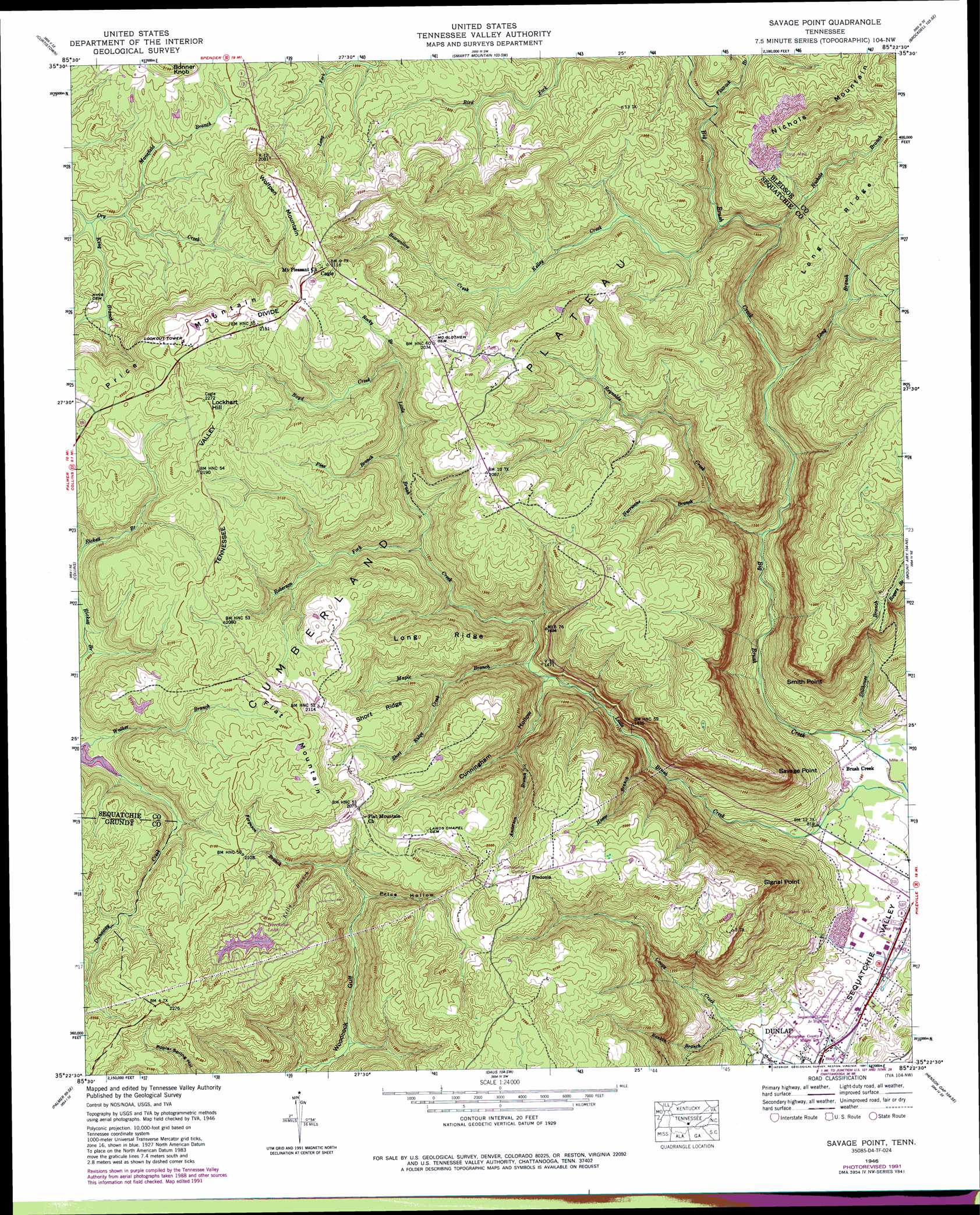
USGS Topo Quad 35085d4 - 1:24,000 scale
| Topo Map Name: | Savage Point |
| USGS Topo Quad ID: | 35085d4 |
| Print Size: | ca. 21 1/4" wide x 27" high |
| Southeast Coordinates: | 35.375° N latitude / 85.375° W longitude |
| Map Center Coordinates: | 35.4375° N latitude / 85.4375° W longitude |
| U.S. State: | TN |
| Filename: | o35085d4.jpg |
| Download Map JPG Image: | Savage Point topo map 1:24,000 scale |
| Map Type: | Topographic |
| Topo Series: | 7.5´ |
| Map Scale: | 1:24,000 |
| Source of Map Images: | United States Geological Survey (USGS) |
| Alternate Map Versions: |
Savage Point TN 1936 Download PDF Buy paper map Savage Point TN 1946 Download PDF Buy paper map Savage Point TN 1946, updated 1960 Download PDF Buy paper map Savage Point TN 1946, updated 1974 Download PDF Buy paper map Savage Point TN 1946, updated 1991 Download PDF Buy paper map Savage Point TN 1947, updated 1948 Download PDF Buy paper map Savage Point TN 2010 Download PDF Buy paper map Savage Point TN 2013 Download PDF Buy paper map Savage Point TN 2016 Download PDF Buy paper map |
1:24,000 Topo Quads surrounding Savage Point
Cardwell Mountain |
Welchland |
Spencer |
Sampson |
Billingsley Gap |
Irving College |
Curtistown |
Smartt Mountain |
Brockdell |
Pikeville |
Altamont |
Collins |
Savage Point |
Mount Airy |
Brayton |
Tracy City |
Palmer |
Daus |
Henson Gap |
Soddy |
White City |
Whitwell |
Ketner Gap |
Fairmount |
Daisy |
> Back to 35085a1 at 1:100,000 scale
> Back to 35084a1 at 1:250,000 scale
> Back to U.S. Topo Maps home
Savage Point topo map: Gazetteer
Savage Point: Capes
Savage Point elevation 544m 1784′Signal Point elevation 583m 1912′
Smith Point elevation 543m 1781′
Savage Point: Dams
Deerhead Dam elevation 635m 2083′Savage Point: Populated Places
Brush Creek elevation 243m 797′Cagle elevation 642m 2106′
Fredonia elevation 635m 2083′
Savage Point: Reservoirs
Deerhead Lake elevation 635m 2083′Savage Point: Ridges
Long Ridge elevation 605m 1984′Long Ridge elevation 573m 1879′
Short Ridge elevation 635m 2083′
Savage Point: Streams
Anderson Branch elevation 399m 1309′Bearwallow Creek elevation 523m 1715′
Boyd Creek elevation 563m 1847′
Ferguson Branch elevation 542m 1778′
Flatrock Branch elevation 481m 1578′
Hester Branch elevation 344m 1128′
Hurricane Branch elevation 399m 1309′
Kelley Creek elevation 438m 1437′
Kelly Branch elevation 570m 1870′
King Branch elevation 567m 1860′
Long Branch elevation 383m 1256′
Mansfield Branch elevation 568m 1863′
Maple Branch elevation 423m 1387′
Nichols Branch elevation 439m 1440′
Pine Branch elevation 530m 1738′
Rankin Branch elevation 251m 823′
Reynolds Creek elevation 319m 1046′
Rickett Branch elevation 585m 1919′
Roberson Fork elevation 490m 1607′
Rocky Branch elevation 566m 1856′
Short Ridge Creek elevation 496m 1627′
Savage Point: Summits
Flat Mountain elevation 684m 2244′Lockhart Hill elevation 694m 2276′
Nichols Mountain elevation 623m 2043′
Wolfpen Mountain elevation 664m 2178′
Savage Point: Valleys
Cunningham Hollow elevation 403m 1322′Price Hollow elevation 543m 1781′
Savage Point digital topo map on disk
Buy this Savage Point topo map showing relief, roads, GPS coordinates and other geographical features, as a high-resolution digital map file on DVD: