Tracy City Topo Map Tennessee
To zoom in, hover over the map of Tracy City
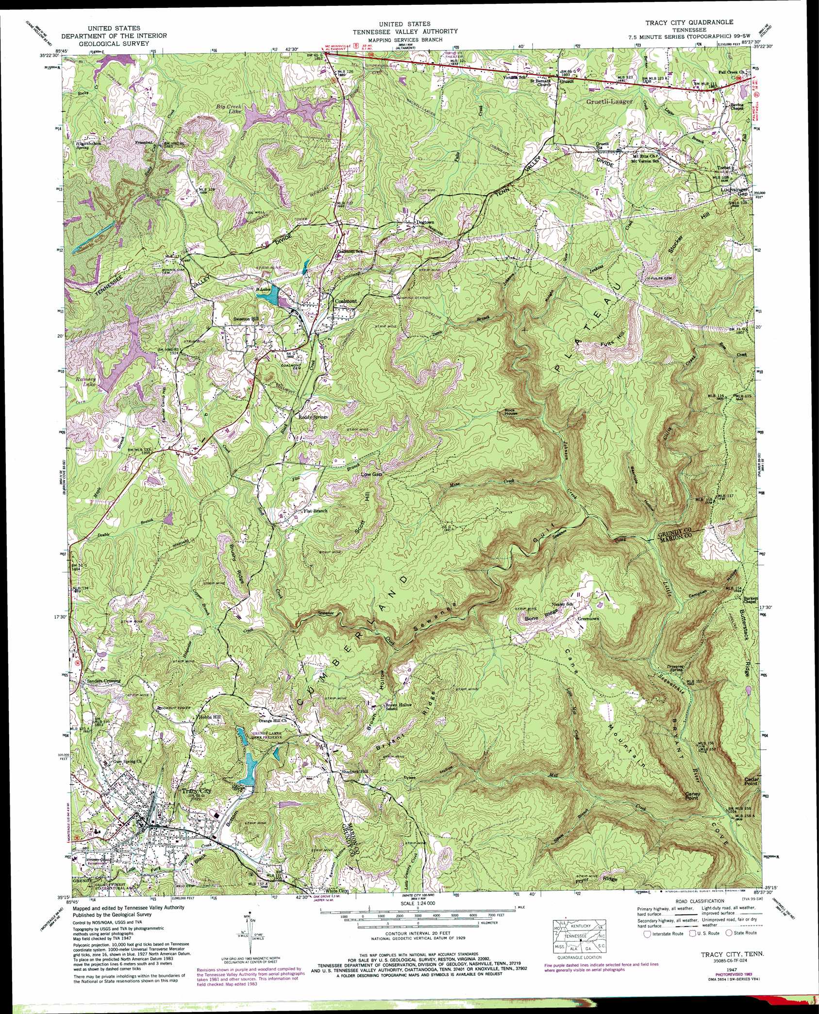
USGS Topo Quad 35085c6 - 1:24,000 scale
| Topo Map Name: | Tracy City |
| USGS Topo Quad ID: | 35085c6 |
| Print Size: | ca. 21 1/4" wide x 27" high |
| Southeast Coordinates: | 35.25° N latitude / 85.625° W longitude |
| Map Center Coordinates: | 35.3125° N latitude / 85.6875° W longitude |
| U.S. State: | TN |
| Filename: | o35085c6.jpg |
| Download Map JPG Image: | Tracy City topo map 1:24,000 scale |
| Map Type: | Topographic |
| Topo Series: | 7.5´ |
| Map Scale: | 1:24,000 |
| Source of Map Images: | United States Geological Survey (USGS) |
| Alternate Map Versions: |
Tracy City TN 1936 Download PDF Buy paper map Tracy City TN 1947, updated 1974 Download PDF Buy paper map Tracy City TN 1947, updated 1975 Download PDF Buy paper map Tracy City TN 1947, updated 1984 Download PDF Buy paper map Tracy City TN 1947, updated 1984 Download PDF Buy paper map Tracy City TN 1950 Download PDF Buy paper map Tracy City TN 2010 Download PDF Buy paper map Tracy City TN 2013 Download PDF Buy paper map Tracy City TN 2016 Download PDF Buy paper map |
1:24,000 Topo Quads surrounding Tracy City
Morrison |
Viola |
Irving College |
Curtistown |
Smartt Mountain |
Hillsboro |
Cane Hollow |
Altamont |
Collins |
Savage Point |
Alto |
Burrow Cove |
Tracy City |
Palmer |
Daus |
Sewanee |
Monteagle |
White City |
Whitwell |
Ketner Gap |
Sinking Cove |
Orme |
South Pittsburg |
Sequatchie |
Wauhatchie |
> Back to 35085a1 at 1:100,000 scale
> Back to 35084a1 at 1:250,000 scale
> Back to U.S. Topo Maps home
Tracy City topo map: Gazetteer
Tracy City: Bends
Black Bottom elevation 555m 1820′Tracy City: Capes
Caney Point elevation 506m 1660′Cedar Point elevation 507m 1663′
Tracy City: Dams
Big Creek Utility Dam elevation 556m 1824′Grundy Lake Dam Number Four elevation 584m 1916′
Grundy Lake Number One Dam elevation 564m 1850′
Grundy Lake Number Two Dam elevation 570m 1870′
Lake Echo Dam elevation 581m 1906′
Ramsey Lake Dam elevation 572m 1876′
Tracy City: Gaps
Low Gap elevation 585m 1919′Luchsinger Gap elevation 584m 1916′
Tracy City: Parks
Grundy Lakes Game Preserve elevation 575m 1886′Tracy City: Pillars
Rock House elevation 543m 1781′Tracy City: Populated Places
Coalmont elevation 575m 1886′Dogtown elevation 579m 1899′
Flat Branch elevation 566m 1856′
Freemont elevation 580m 1902′
Greentown elevation 549m 1801′
Gruetli elevation 577m 1893′
Hobbs Hill elevation 649m 2129′
Sanders Crossing elevation 585m 1919′
Shadrick Hill elevation 618m 2027′
Sweeton Hill elevation 609m 1998′
Torbet elevation 585m 1919′
Tracy City elevation 555m 1820′
Tracy City: Post Offices
Gruetli-Laager Post Office elevation 577m 1893′Tracy City: Reservoirs
B Lakes elevation 570m 1870′Big Creek Lake elevation 549m 1801′
Big Creek Utility Lake elevation 556m 1824′
Grundy Lake Number Four elevation 584m 1916′
Grundy Lake Number One elevation 564m 1850′
Grundy Lake Number Two elevation 570m 1870′
Lake Echo elevation 581m 1906′
Ramsey Lake elevation 572m 1876′
Tracy City: Ridges
Bone Ridge elevation 573m 1879′Brushy Ridge elevation 611m 2004′
Bryant Ridge elevation 617m 2024′
Tennessee Valley Divide elevation 592m 1942′
Tennessee Valley Divide elevation 592m 1942′
Tennessee Valley Divide elevation 592m 1942′
Tracy City: Springs
Dripping Spring elevation 332m 1089′Higgenbotham Spring elevation 567m 1860′
Roddy Springs elevation 562m 1843′
Tracy City: Streams
Black Creek elevation 555m 1820′Clifty Creek elevation 347m 1138′
Copper Branch elevation 553m 1814′
Davis Branch elevation 479m 1571′
Double Branch elevation 561m 1840′
Douglass Creek elevation 337m 1105′
Flat Branch elevation 548m 1797′
Holywater Creek elevation 517m 1696′
Jenkins Creek elevation 519m 1702′
Johnson Creek elevation 363m 1190′
Layne Branch elevation 559m 1833′
Little Mill Creek elevation 387m 1269′
Mill Creek elevation 301m 987′
Mine Creek elevation 377m 1236′
Q Creek elevation 555m 1820′
Ross Creek elevation 455m 1492′
Scott Creek elevation 522m 1712′
Scrum Branch elevation 368m 1207′
Sewanee Creek elevation 347m 1138′
Tracy City: Summits
Cane Mountain elevation 522m 1712′Farmer Camp Hill elevation 601m 1971′
Fults Hill elevation 619m 2030′
Scott Hill elevation 623m 2043′
Stocker Hill elevation 654m 2145′
Tracy City: Valleys
Bearhole Hollow elevation 360m 1181′Brown Hollow elevation 470m 1541′
Campbell Hollow elevation 344m 1128′
Cannon Hollow elevation 560m 1837′
Dykes Hollow elevation 392m 1286′
Knight Gulf elevation 464m 1522′
Sewanee Gulf elevation 347m 1138′
Tracy City digital topo map on disk
Buy this Tracy City topo map showing relief, roads, GPS coordinates and other geographical features, as a high-resolution digital map file on DVD: