Winchester Topo Map Tennessee
To zoom in, hover over the map of Winchester
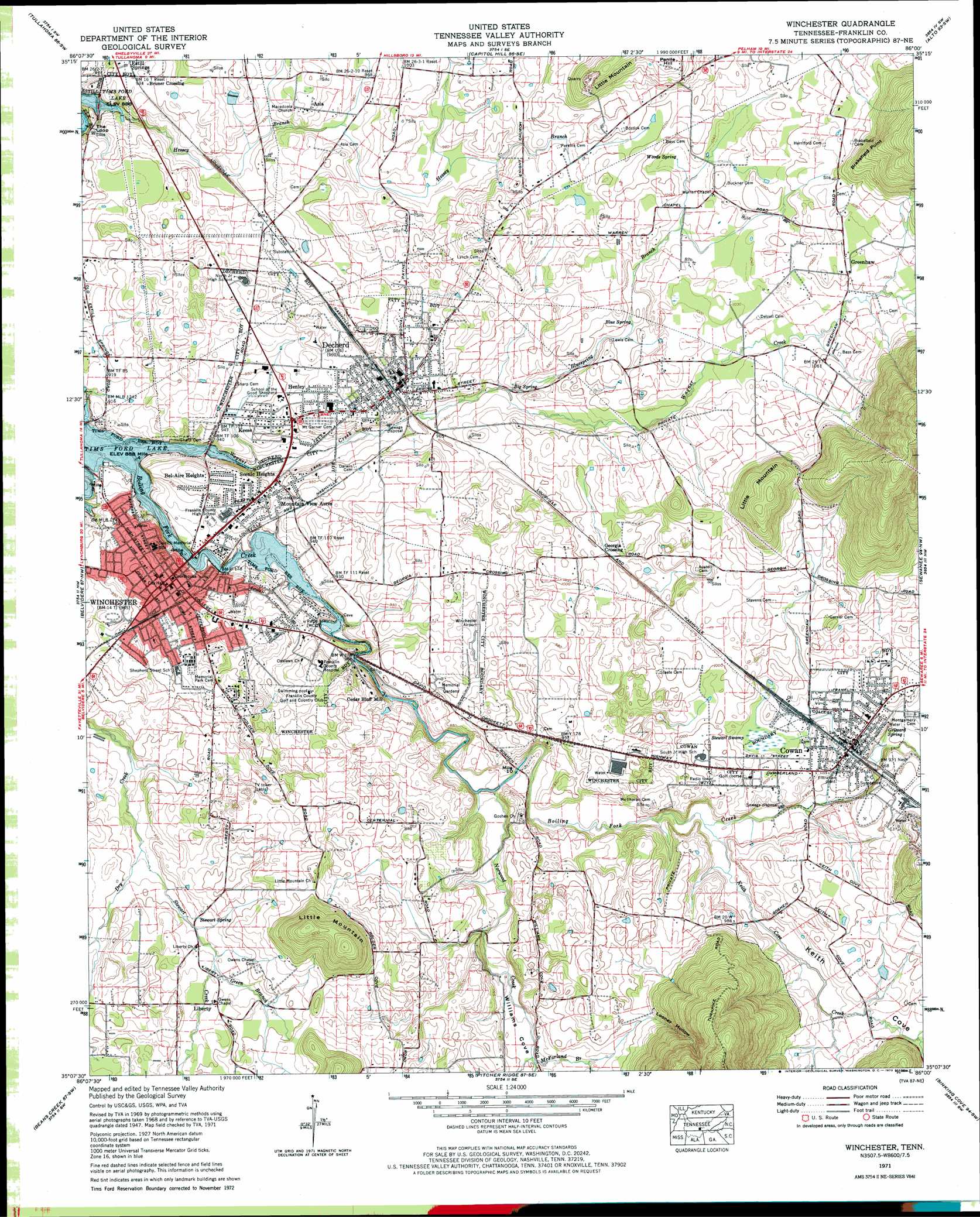
USGS Topo Quad 35086b1 - 1:24,000 scale
| Topo Map Name: | Winchester |
| USGS Topo Quad ID: | 35086b1 |
| Print Size: | ca. 21 1/4" wide x 27" high |
| Southeast Coordinates: | 35.125° N latitude / 86° W longitude |
| Map Center Coordinates: | 35.1875° N latitude / 86.0625° W longitude |
| U.S. State: | TN |
| Filename: | o35086b1.jpg |
| Download Map JPG Image: | Winchester topo map 1:24,000 scale |
| Map Type: | Topographic |
| Topo Series: | 7.5´ |
| Map Scale: | 1:24,000 |
| Source of Map Images: | United States Geological Survey (USGS) |
| Alternate Map Versions: |
Winchester TN 1936 Download PDF Buy paper map Winchester TN 1947, updated 1948 Download PDF Buy paper map Winchester TN 1947, updated 1960 Download PDF Buy paper map Winchester TN 1947, updated 1963 Download PDF Buy paper map Winchester TN 1971, updated 1973 Download PDF Buy paper map Winchester TN 2010 Download PDF Buy paper map Winchester TN 2013 Download PDF Buy paper map Winchester TN 2016 Download PDF Buy paper map |
1:24,000 Topo Quads surrounding Winchester
Normandy |
Normandy Lake |
Manchester |
Hillsboro |
Cane Hollow |
Lynchburg East |
Tullahoma |
Capitol Hill |
Alto |
Burrow Cove |
Lois |
Belvidere |
Winchester |
Sewanee |
Monteagle |
Huntland |
Beans Creek |
Pitcher Ridge |
Sinking Cove |
Orme |
King Cove |
Estill Fork |
Hytop |
Eureka |
Doran Cove |
> Back to 35086a1 at 1:100,000 scale
> Back to 35086a1 at 1:250,000 scale
> Back to U.S. Topo Maps home
Winchester topo map: Gazetteer
Winchester: Airports
King Airport elevation 315m 1033′Winchester Municipal Airport elevation 296m 971′
Winchester: Cliffs
Brakefield Point elevation 378m 1240′Winchester: Populated Places
Asia elevation 300m 984′Bel-Aire Heights elevation 297m 974′
Bruner Crossing elevation 286m 938′
Cowan elevation 297m 974′
Decherd elevation 292m 958′
Greenhaw elevation 321m 1053′
Henley elevation 289m 948′
Keese elevation 297m 974′
Liberty elevation 300m 984′
Mountain View Acres elevation 286m 938′
Scenic Heights elevation 297m 974′
Winchester elevation 298m 977′
Winchester: Post Offices
Cowan Post Office elevation 299m 980′Decherd Post Office elevation 298m 977′
Winchester Post Office elevation 296m 971′
Winchester: Ridges
Millers Bend elevation 481m 1578′Winchester: Springs
Big Spring elevation 289m 948′Blue Spring elevation 301m 987′
Grizzard Spring elevation 289m 948′
Stewart Spring elevation 296m 971′
Woods Spring elevation 315m 1033′
Winchester: Streams
Bluespring Branch elevation 289m 948′Green Branch elevation 294m 964′
Greenhaw Creek elevation 319m 1046′
Keith Cove Creek elevation 282m 925′
McFarland Branch elevation 289m 948′
Norwood Creek elevation 274m 898′
Stewart Creek elevation 284m 931′
Wagner Creek elevation 271m 889′
Winchester: Summits
Little Mountain elevation 385m 1263′Little Mountain elevation 380m 1246′
Penile Hill elevation 351m 1151′
Winchester: Swamps
Stewart Swamp elevation 297m 974′Winchester: Valleys
Keith Cove elevation 284m 931′Looney Hollow elevation 307m 1007′
Williams Cove elevation 280m 918′
Winchester digital topo map on disk
Buy this Winchester topo map showing relief, roads, GPS coordinates and other geographical features, as a high-resolution digital map file on DVD: