Burrow Cove Topo Map Tennessee
To zoom in, hover over the map of Burrow Cove
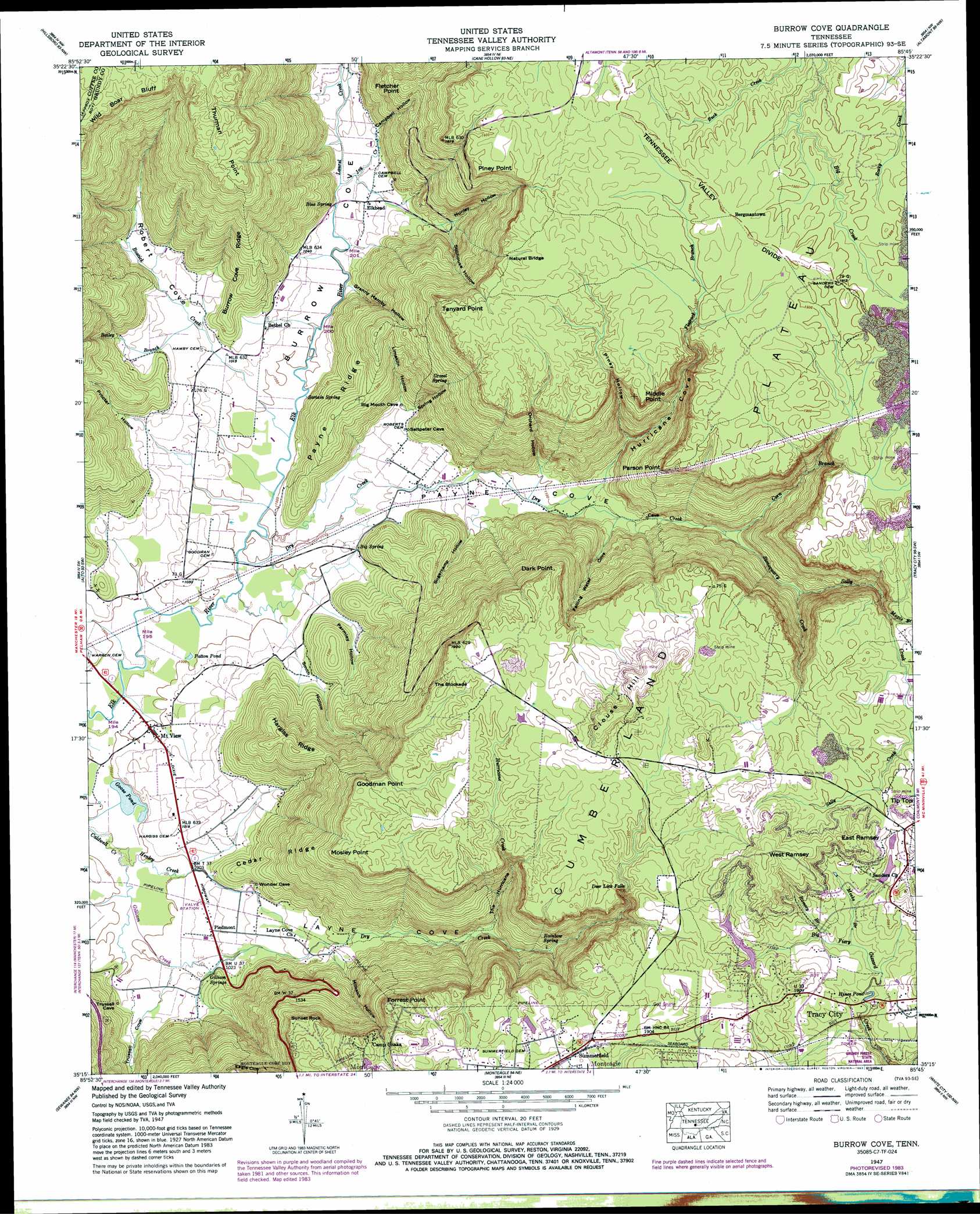
USGS Topo Quad 35085c7 - 1:24,000 scale
| Topo Map Name: | Burrow Cove |
| USGS Topo Quad ID: | 35085c7 |
| Print Size: | ca. 21 1/4" wide x 27" high |
| Southeast Coordinates: | 35.25° N latitude / 85.75° W longitude |
| Map Center Coordinates: | 35.3125° N latitude / 85.8125° W longitude |
| U.S. State: | TN |
| Filename: | o35085c7.jpg |
| Download Map JPG Image: | Burrow Cove topo map 1:24,000 scale |
| Map Type: | Topographic |
| Topo Series: | 7.5´ |
| Map Scale: | 1:24,000 |
| Source of Map Images: | United States Geological Survey (USGS) |
| Alternate Map Versions: |
Burrow Cove TN 1936 Download PDF Buy paper map Burrow Cove TN 1947, updated 1948 Download PDF Buy paper map Burrow Cove TN 1947, updated 1962 Download PDF Buy paper map Burrow Cove TN 1947, updated 1972 Download PDF Buy paper map Burrow Cove TN 1947, updated 1975 Download PDF Buy paper map Burrow Cove TN 1947, updated 1983 Download PDF Buy paper map Burrow Cove TN 1947, updated 1983 Download PDF Buy paper map Burrow Cove TN 2010 Download PDF Buy paper map Burrow Cove TN 2013 Download PDF Buy paper map Burrow Cove TN 2016 Download PDF Buy paper map |
1:24,000 Topo Quads surrounding Burrow Cove
Fredonia |
Morrison |
Viola |
Irving College |
Curtistown |
Manchester |
Hillsboro |
Cane Hollow |
Altamont |
Collins |
Capitol Hill |
Alto |
Burrow Cove |
Tracy City |
Palmer |
Winchester |
Sewanee |
Monteagle |
White City |
Whitwell |
Pitcher Ridge |
Sinking Cove |
Orme |
South Pittsburg |
Sequatchie |
> Back to 35085a1 at 1:100,000 scale
> Back to 35084a1 at 1:250,000 scale
> Back to U.S. Topo Maps home
Burrow Cove topo map: Gazetteer
Burrow Cove: Bridges
Elk Bridge elevation 302m 990′Burrow Cove: Capes
Duck Point elevation 569m 1866′Fletcher Point elevation 475m 1558′
Forrest Point elevation 590m 1935′
Goodman Point elevation 564m 1850′
Middle Point elevation 561m 1840′
Mosley Point elevation 552m 1811′
Parson Point elevation 580m 1902′
Piney Point elevation 542m 1778′
Tanyard Point elevation 580m 1902′
Thurman Point elevation 580m 1902′
Burrow Cove: Cliffs
Eagle Cliff elevation 547m 1794′Burrow Cove: Dams
Highlander Pond Dam elevation 573m 1879′Littell Number One Lake Dam elevation 570m 1870′
Plainview Dam elevation 569m 1866′
Burrow Cove: Falls
Deer Lick Falls elevation 555m 1820′Burrow Cove: Lakes
Duck Pond elevation 303m 994′Goose Pond elevation 302m 990′
Hines Pond elevation 548m 1797′
Patton Pond elevation 304m 997′
Burrow Cove: Mines
Clouse Hill Mines elevation 407m 1335′Shetter Quarry elevation 310m 1017′
Burrow Cove: Parks
Grundy Forest State Natural Area elevation 533m 1748′Burrow Cove: Pillars
Sunset Rock elevation 559m 1833′Burrow Cove: Populated Places
Bergmantown elevation 589m 1932′Clouse Hill elevation 598m 1961′
Elkhead elevation 314m 1030′
Mount View elevation 306m 1003′
Payne Cove elevation 314m 1030′
Piedmont elevation 310m 1017′
Sartain Springs elevation 597m 1958′
Summerfield elevation 585m 1919′
Valley Home elevation 310m 1017′
Burrow Cove: Reservoirs
Highlander Pond elevation 573m 1879′Littell Number One Lake elevation 570m 1870′
Plainview Lake elevation 569m 1866′
Burrow Cove: Ridges
Burrow Cove Ridge elevation 392m 1286′Cedar Ridge elevation 385m 1263′
Hargiss Ridge elevation 458m 1502′
Payne Ridge elevation 397m 1302′
Burrow Cove: Springs
Big Spring elevation 316m 1036′Blue Spring elevation 308m 1010′
Gilliam Springs elevation 310m 1017′
Gravel Spring elevation 469m 1538′
Rainbow Spring elevation 422m 1384′
Sartain Spring elevation 316m 1036′
Burrow Cove: Streams
Bailey Branch elevation 311m 1020′Blue Spring Branch elevation 302m 990′
Bostick Creek elevation 303m 994′
Corn Branch elevation 372m 1220′
Dry Creek elevation 302m 990′
Dry Creek elevation 308m 1010′
Flatrock Branch elevation 333m 1092′
Gilliam Creek elevation 302m 990′
Henley Creek elevation 302m 990′
Hurricane Creek elevation 372m 1220′
Joy Creek elevation 308m 1010′
Laurel Creek elevation 308m 1010′
Little Fiery Gizzard Creek elevation 513m 1683′
Maple Branch elevation 538m 1765′
Meeks Branch elevation 554m 1817′
Ramsey Branch elevation 554m 1817′
Sally Creek elevation 407m 1335′
Stonequarry Creek elevation 371m 1217′
Trussell Creek elevation 305m 1000′
Woodly Branch elevation 566m 1856′
Burrow Cove: Summits
Broad Mountain elevation 592m 1942′Clouse Hill elevation 634m 2080′
East Ramsey elevation 616m 2020′
The Blockade elevation 567m 1860′
Tip Top elevation 597m 1958′
West Ramsey elevation 627m 2057′
Burrow Cove: Valleys
Burrow Cove elevation 315m 1033′Campbell Hollow elevation 336m 1102′
Corn Branch Cove elevation 379m 1243′
Falling Water Cove elevation 366m 1200′
Fults Hollow elevation 323m 1059′
Granny Hamby Hollow elevation 310m 1017′
Hurricane Cove elevation 348m 1141′
Laster Hollow elevation 311m 1020′
Layne Cove elevation 310m 1017′
Limekiln Hollow elevation 319m 1046′
Milksick Hollow elevation 346m 1135′
Nunley Hollow elevation 342m 1122′
Orchard Hollow elevation 336m 1102′
Parmley Hollow elevation 309m 1013′
Payne Cove elevation 305m 1000′
Piney Hollow elevation 374m 1227′
Procter Hollow elevation 311m 1020′
Robert Cove elevation 310m 1017′
Smith Hollow elevation 308m 1010′
Spring Hollow elevation 323m 1059′
Stillhouse Hollow elevation 357m 1171′
Sugarcamp Hollow elevation 329m 1079′
The Hurricane elevation 384m 1259′
Trussell Cove elevation 308m 1010′
Burrow Cove digital topo map on disk
Buy this Burrow Cove topo map showing relief, roads, GPS coordinates and other geographical features, as a high-resolution digital map file on DVD: